
Ladakh is a region administered by India as a union territory, and constitutes a part of the larger Kashmir region, which has been the subject of dispute between India, Pakistan, and China since 1947. Ladakh is bordered by the Tibet Autonomous Region to the east, the Indian state of Himachal Pradesh to the south, both the Indian-administered union territory of Jammu and Kashmir and the Pakistan-administered Gilgit-Baltistan to the west, and the southwest corner of Xinjiang across the Karakoram Pass in the far north. It extends from the Siachen Glacier in the Karakoram range to the north to the main Great Himalayas to the south. The eastern end, consisting of the uninhabited Aksai Chin plains, is claimed by the Indian Government as part of Ladakh, and has been under Chinese control since 1962.

Tibetan Muslims, also known as the Kachee, form a small minority in Tibet. Despite being Muslim, they are officially recognized as Tibetans by the government of the People's Republic of China, unlike the Hui Muslims, who are separately recognized. The Tibetan word Kachee literally means Kashmiri and Kashmir was known as Kachee Yul. The Muslim community in Tibet is very diverse, with Muslims being of Kashmiri, Chinese, Nepalese, Ladakhi, and Indian origin.

Shiquanhe, known in Tibetan as Sênggêkanbab or Sênggêzangbo, is the main town and administrative seat of Ngari Prefecture, Tibet Autonomous Region, China. Shiquanhe is located on the bank of Sênggê Zangbo, the main headwater of the Indus River, close to its confluence with the Gartang River.

Ladakh has a long history with evidence of human settlement from as back as 9000 b.c. It has been the cross road of high asia for thousands of years and has seen many cultures, empires and technologies taking birth in its neighbours. As a result of these developments Ladakh has imported many traditions and culture from its neighbours and combining them all gave rise to a unique tradition and culture of its own.

The Ladakh Range is a mountain range in central Ladakh in the Indian Union territory of Ladakh with its northern tip extending into Ladakh in India. It lies between the Indus and Shyok river valleys, stretching to 230 miles (370 km). Leh, the capital city of Ladakh, is on the foot of Ladakh Range in the Indus river valley.

Tingmosgang is a fortress in Temisgam village, on the bank of Indus River in Ladakh, in northwestern India. It is 92 km west of Leh, near Khalatse, and north of the present main road. The town has a palace and the monastery over a hillock.

Shey is a village in the Leh district of Ladakh, India. It is located in the Leh tehsil, 15 km from Leh towards Hemis.
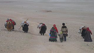
The Changtang is a part of the high altitude Tibetan Plateau in western and northern Tibet extending into the southern edges of Xinjiang as well as southeastern Ladakh, India, with vast highlands and giant lakes. From eastern Ladakh, the Changtang stretches approximately 1,600 kilometres (990 mi) east into Tibet as far as modern Qinghai. The Changtang is home to the Changpa, a nomadic Tibetan people. The two largest settlements within the Tibetan Changtang are Rutog Town the seat of Rutog County and Domar Township the seat of Shuanghu County.

Zorawar Singh Kahluria was a military general of Dogra Rajput ruler Gulab Singh of Jammu, He served as the governor (wazir-e-wazarat) of Kishtwar and extended the territories of the kingdom by conquering Ladakh and Baltistan. He also boldly attempted the conquest of Western Tibet but was killed in battle of To-yo during the Dogra-Tibetan war. In reference to his legacy of conquests in the Himalaya Mountains including Ladakh, Tibet, Baltistan and Iskardu as General and Wazir, Zorowar Singh has been referred to as the "Napoleon of India", and "Conqueror of Ladakh".

Simbiling Monastery, also known as Shambuling Gompa, Shepeling Dzong and Taklakot Gompa, was located next to the large fort of Tegla Kar on a ridge near Taklakot, above the town of Purang, in the Ngari province, which is just over the border from India, in western Tibet in the valley of the Karnali River, which is known in Tibet as the Mapchchu Khambab - the 'Peacock Mouth River' or 'River Formed from the Mouth of a Peacock'.
Dêmqog, traditionally transliterated as Demchok, is a village in the disputed Demchok sector that is administered as part of the Ngari Prefecture, Tibet Autonomous Region by China.
Xaidulla, also spelled Shahidullah and Shahidula, also Saitula from Mandarin Chinese, is a town in Pishan County in the southwestern part of Xinjiang Autonomous Region, China. It is strategically located on the upper Karakash River, just to the north of the Karakoram Pass on the old caravan route between the Tarim Basin and Ladakh. It lies next to the Chinese National Highway G219 between Kashgar and Tibet, 25 km east of Mazar and 115 km west of Dahongliutan.

Hanle Monastery is a 17th-century gompa of the Drukpa Lineage of the Kagyu school of Tibetan Buddhism located in the Hanle Valley, Leh district, Ladakh, India on an old branch of the ancient Ladakh-Tibet trade route. The valley is home to about a thousand people, with about 300 people living in Hanle village. The monastery is home to about ten monks while another 33 or so come regularly for prayers. It is only 19 kilometres (12 mi) from the disputed frontier between India and Chinese-controlled Tibet.

Maryul of Ngari, or the Kingdom of Ladakh, was a west Tibetan kingdom based in modern-day Ladakh and Tibet Autonomous Region. The Maryul kingdom was based in Shey and evolved into the modern Ladakh.
The Dogra–Tibetan War or Sino-Sikh War was fought from May 1841 to August 1842, between the forces of the Dogra nobleman Gulab Singh of Jammu, under the suzerainty of the Sikh Empire, and Tibet under the suzerainty of Qing China. Gulab Singh's commander was the able general Zorawar Singh Kahluria, who, after the conquest of Ladakh, attempted to extend its boundaries in order to control the trade routes into Ladakh. Zorawar Singh's campaign, suffering from the effects of inclement weather, suffered a defeat at Minsar and Singh was killed. The Tibetans then advanced on Ladakh. Gulab Singh sent reinforcements under the command of his nephew Jawahir Singh. A subsequent battle near Leh in 1842 led to a Tibetan defeat. The Treaty of Chushul was signed in 1842 maintaining the status quo ante bellum.
The Tibet–Ladakh–Mughal War of 1679–1684 was fought between the Central Tibetan Ganden Phodrang government, with the assistance of Mongol khanates, and the Namgyal dynasty of Ladakh with assistance from the Mughal Empire in Kashmir.

Demchok , previously called New Demchok, and Parigas by the Chinese, is a village and military encampment in the Indian-administered Demchok sector that is disputed between India and China. It is administered as part of the Nyoma tehsil in the Leh district of Ladakh by India, and claimed by China as part of the Tibet Autonomous Region.
Tangtse (Tanktse or Tankse) is a village in the Leh district of Ladakh, India. It is located in the Durbuk tehsil. Traditionally, it was regarded as the border between the Nubra region to the north and the Pangong region to the south. It was a site of wars between Ladakh and Tibet.

The Demchok sector is a disputed region named after the villages of Demchok, Ladakh and Demchok, Tibet, situated near the confluence of the Charding Nullah and Indus River. It is part of the greater Sino-Indian border dispute between China and India. Both India and China claim the disputed region, with a Line of Actual Control between the two nations situated along the Charding Nullah.
The Ladakh Chronicles, or La-dvags-rgyal-rabs, is a historical work that covers the history of Ladakh from the beginnings of the first Tibetan dynasty of Ladakh until the end of the Namgyal dynasty. The chronicles were compiled by the Namgyal dynasty, mostly during the 17th century, and are considered to be the main written source for Ladakhi history.


