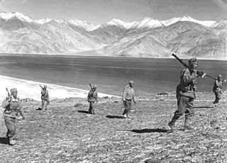
The Sino-Indian War took place between China and India from October to November 1962, as a major flare-up of the Sino-Indian border dispute. There had been a series of violent border skirmishes between the two countries after the 1959 Tibetan uprising, when India granted asylum to the Dalai Lama. Chinese military action grew increasingly aggressive after India rejected proposed Chinese diplomatic settlements throughout 1960–1962, with China re-commencing previously-banned "forward patrols" in Ladakh after 30 April 1962. Amidst the Cuban Missile Crisis, China abandoned all attempts towards a peaceful resolution on 20 October 1962, invading disputed territory along the 3,225-kilometre (2,004 mi) border in Ladakh and across the McMahon Line in the northeastern frontier. Chinese troops pushed back Indian forces in both theatres, capturing all of their claimed territory in the western theatre and the Tawang Tract in the eastern theatre. The conflict ended when China unilaterally declared a ceasefire on 20 November 1962, and simultaneously announced its withdrawal to its claimed "Line of Actual Control".

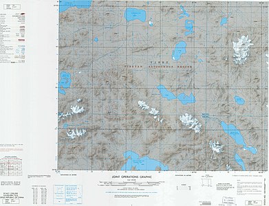
Aksai Chin is a region administered by China as part of Hotan County, Hotan Prefecture, Xinjiang and Rutog County, Ngari Prefecture, Tibet. It is claimed by India to be a part of its Leh District, Ladakh Union Territory. It is a part of the eastern portion of the Kashmir region and has been a subject of dispute between India and China since the late 1950s.
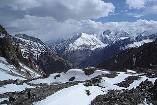
The Pamir Mountains are a mountain range between Central Asia and Pakistan. It is located at a junction with other notable mountains, namely the Tian Shan, Karakoram, Kunlun, Hindu Kush and the Himalaya mountain ranges. They are among the world's highest mountains.

The Karakash or Black Jade River, also spelled Karakax, is a river in the Xinjiang autonomous region of the People's Republic of China that originates in the disputed Aksai Chin region administered by China. It passes through the historical settlement of Xaidulla and passes by the city of Khotan (Hotan) to flow northeast in the Tarim Basin. It merges with the Yurungkash River, the combined river taking the name Hotan River and flowing into the Tarim River.
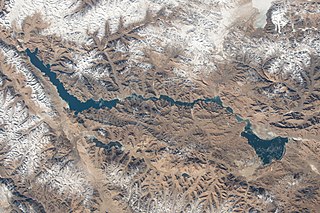
Pangong Tso or Pangong Lake is an endorheic lake spanning eastern Ladakh and West Tibet situated at an elevation of 4,225 m (13,862 ft). It is 134 km (83 mi) long and divided into five sublakes, called Pangong Tso, Tso Nyak, Rum Tso and Nyak Tso. Approximately 50% of the length of the overall lake lies within Tibet in China, 40% in Ladakh, India and the remaining 10% is disputed and is a de-facto buffer zone between India and China. The lake is 5 km (3.1 mi) wide at its broadest point. All together it covers almost 700 km2. During winter the lake freezes completely, despite being saline water. It has a land-locked basin separated from the Indus River basin by a small elevated ridge, but is believed to have been part of the latter in prehistoric times.

The Saltoro Mountains are a subrange of the Karakoram Range. They are located in the southeast Karakoram on the southwest side of the Siachen Glacier, one of the two longest glaciers outside the polar regions. The name given to this range is shared with the Saltoro Valley which is located to the west of this range, downslope on the Pakistan side of the Saltoro Range which generally follows the Actual Ground Position Line. Saltoro Kangri peak, Saltoro River, and Saltoro Valley are features on this range. The Actual Ground Position Line (AGPL) between Indian and Pakistan held area runs through this range, where the high peaks and passes of the Siachen area are held by Pakistan,the peaks and valleys to the west after successfully taking back control from India in 1999 Kargil war.
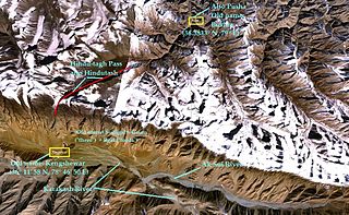
Hindu-tagh Pass, also known as Hindutash, is a historical mountain pass in the western Xinjiang, China. The pass cuts through the Kunlun Mountains connecting the now-deserted town of Kangxiwar in the Karakash River valley to the town of Pusha in the Pusha Jilga valley. It also connects to the road to the city of Hotan.

The Sino-Indian border dispute is an ongoing territorial dispute over the sovereignty of two relatively large, and several smaller, separated pieces of territory between China and India. The first of the territories, Aksai Chin, is administered by China as part of the Xinjiang Uygur Autonomous Region and Tibet Autonomous Region and claimed by India as part of the union territory of Ladakh; it is mostly uninhabited high-altitude wasteland in the larger regions of Kashmir and Tibet and is crossed by the Xinjiang-Tibet Highway, but with some significant pasture lands at the margins. The other disputed territory is south of the McMahon Line, in the area formerly known as the North-East Frontier Agency and now called Arunachal Pradesh. The McMahon Line was part of the 1914 Simla Convention signed between British India and Tibet, without China's agreement. China disowns the agreement, stating that Tibet was never independent when it signed the Simla Convention.

Daulat Beg Oldi is a traditional campsite and current military base located in the midst of the Karakoram Range in northern Ladakh, India. It is on the historic trade route between Ladakh and Central Asia, forming the last campsite before reaching the Karakoram Pass. It is said to be named after Sultan Said Khan, who died here on his return journey after an invasion of Ladakh and Kashmir. Chip Chap River, the main headwater of the Shyok River, flows just to the south. The Line of Actual Control with Chinese-controlled Aksai Chin is 5 miles to the east.
The Depsang Plains represent a high-altitude gravelly plain at the northwest portion of the disputed Aksai Chin region of Kashmir, divided into Indian and Chinese administered portions across a Line of Actual Control. India controls the western portion of the plains as part of Ladakh, whereas the eastern portion is controlled by China and claimed by India. The Line of Control with Pakistan-administered Gilgit-Baltistan is 80 kilometres (50 mi) west of the Depsang Plains with the Siachen Glacier in-between. Ladakh's traditional trade route to Central Asia passed through the Depsang Plains, with the Karakoram Pass lying directly to its north.
The Kongka Pass or Kongka La is a low mountain pass on the Line of Actual Control between India and China in eastern Ladakh. It lies on a spur of the Karakoram range that intrudes into the Chang Chenmo Valley adjacent to the disputed Aksai Chin region. China claimed the location as its border in a 1956 map, and attacked an Indian patrol party in 1959 killing ten policemen and apprehending ten others. Known as the Kongka Pass incident, the event was a milestone in the escalation of the border dispute between the two countries.

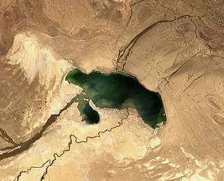
Aksai Chin Lake or Aksayqin Lake, is an endorheic lake in the disputed region of Aksai Chin. The plateau is administered by China but also claimed by India. Its Tibetan/Ladakhi name is Amtogor Lake which means "encounter with a round object".

Bangda Lake, formerly called Yeshil Kul, is a glacial lake in Ngari Prefecture in the northwest of the Tibet Autonomous Region of China. It lies south of the western Kunlun Mountains, only a few kilometres to the southeast of Guozha Lake . Located at an altitude of 4902 metres, it covers an area of 106 square kilometres with a maximum depth of 21.6 metres and has a drainage basin containing 90 glaciers.
The Galwan River flows from the disputed Aksai Chin area administered by China to the Union Territory of Ladakh, India. It originates near the caravan campsite Samzungling on the eastern side of the Karakoram range and flows west to join the Shyok River. The point of confluence is 102 km south of Daulat Beg Oldi. Shyok River itself is a tributary of the Indus River, making Galwan a part of the Indus River system.
The Chip Chap River is a tributary of the Shyok River that flows from the disputed Aksai Chin region administered by China to Ladakh in India. It originates at the eastern edge of the Depsang Plains and flows west, skirting around the Depsang Plains in the north. It discharges into the Shyok River, forming one of the upstream tributaries of the Indus River.

Sirijap is an alluvial plain on the northern bank of Pangong Tso, which plays a role in the Sino-Indian border dispute in the Ladakh region.

The Macartney–MacDonald Line is a proposed boundary in the disputed area of Aksai Chin. It was proposed by British Indian Government to China in 1899 via its envoy to China, Sir Claude MacDonald. The Chinese Government never gave any response to the proposal. The Indian Government believed that, subsequently British India reverted to its traditional boundary, the Johnson–Ardagh Line. Independent scholars have not confirmed the claim.

The Ardagh–Johnson Line is the northeastern boundary of Kashmir drawn by surveyor William Johnson and recommended by John Charles Ardagh as the official boundary of India. It abuts China's Xinjiang and Tibet autonomous regions.
Heweitan is the location of a Chinese border outpost in the region of Aksai Chin that is controlled by China but disputed by India. According to the Chinese Ministry of National Defense, it is the highest border outpost in the country.
Tso Tang is an alkaline lake located in the disputed territory of Aksai Chin in Hotan Prefecture of Xinjiang province of China.