Tibet is a region in the central part of East Asia, covering much of the Tibetan Plateau and spanning about 2,500,000 km2 (970,000 sq mi). It is the homeland of the Tibetan people. Also resident on the plateau are some other ethnic groups such as the Monpa, Tamang, Qiang, Sherpa and Lhoba peoples and, since the 20th century, considerable numbers of Han Chinese and Hui settlers. Since the 1951 annexation of Tibet by the People's Republic of China, the entire plateau has been under the administration of the People's Republic of China. Tibet is divided administratively into the Tibet Autonomous Region, and parts of the Qinghai and Sichuan provinces. Tibet is also constitutionally claimed by the Republic of China as the Tibet Area since 1912.

The Tibet Autonomous Region or Xizang Autonomous Region, often shortened to Tibet or Xizang, is an autonomous region of the People's Republic of China in Southwest China. It was overlayed on the traditional Tibetan regions of Ü-Tsang and Kham.

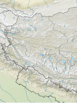
The geography of Tibet consists of the high mountains, lakes and rivers lying between Central, East and South Asia. Traditionally, Western sources have regarded Tibet as being in Central Asia, though today's maps show a trend toward considering all of modern China, including Tibet, to be part of East Asia. Tibet is often called "the roof of the world," comprising tablelands averaging over 4,950 metres above the sea with peaks at 6,000 to 7,500 m, including Mount Everest, on the border with Nepal.

Mount Kailash, is a mountain in the Ngari Prefecture, Tibet Autonomous Region of China. It has an altitude of 6,638 m (21,778 ft). It lies in the Kailash Range of the Transhimalaya, in the western part of the Tibetan Plateau. Mount Kailash is less than 100 km north of the western trijunction of the borders of China, India, and Nepal.
Jelep La elevation 14,390 feet (4,390 m), is a high mountain pass between Sikkim, India and Tibet Autonomous Region, China. It is on a route that connects Lhasa to India. The pass is about 4 km (2.5 mi) south of Nathu La and is slightly higher. It was frequently used for trade between Tibet and India during the British Raj, with Kalimpong serving as the contact point. The Menmecho Lake lies below the Jelep La.
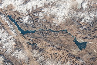
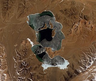
Pangong Tso or Pangong Lake is an endorheic lake spanning eastern Ladakh and West Tibet situated at an elevation of 4,225 m (13,862 ft). It is 134 km (83 mi) long and divided into five sublakes, called Pangong Tso, Tso Nyak, Rum Tso and Nyak Tso. Approximately 50% of the length of the overall lake lies within Tibet in China, 40% in Ladakh, India and the remaining 10% is disputed and is a de facto buffer zone between India and China. The lake is 5 km (3.1 mi) wide at its broadest point. All together it covers almost 700 km2. During winter the lake freezes completely, despite being saline water. It has a land-locked basin separated from the Indus River basin by a small elevated ridge, but is believed to have been part of the latter in prehistoric times.
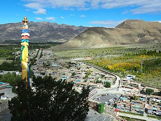
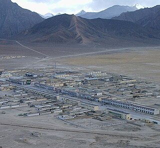
Shannan, also known as Lhoka, is a prefecture in the southeastern Tibet Autonomous Region, China. Shannan includes Gonggar County within its jurisdiction with Gongkar Chö Monastery, Gonggar Dzong, and Gonggar Airport all located near Gonggar town.
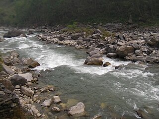
Bhote Koshi in Nepal and Poiqu in Tibet, both names roughly mean "Tibetan river," is the name given to the upper course of the Sun Kosi river. It is part of the Koshi River system in Nepal.
Rutog County is a county in Ngari Prefecture, Tibet Autonomous Region, China. The county seat is the new Rutog Town, located some 1,140 km (710 mi) or 700 miles west-northwest of the Tibetan capital, Lhasa. Rutog County shares a border with India.

Xainza County, also Shantsa, Shentsa, is a county within Nagqu of the Tibet Autonomous Region of China. In 1999 the county had a population of 16,190.

Shuanghu County, also transliterated from Tibetan as Conyi County, is a county under the jurisdiction of the prefecture-level city of Nagqu, in the northernmost part of the Tibet Autonomous Region, China. It was formed in 2012, combining the territory of the former Shuanghu Special District with the eastern half of Nyima County. Much of the county is within the Changtang area.

Siling Lake, is a lake in the Tibet Autonomous Region, China to the north of Xainza. Doijiang is located near the lake. Administratively it belongs to Xainza County and Baingoin County of the Nagqu.
The Kongka Pass or Kongka La is a low mountain pass on the Line of Actual Control between India and China in eastern Ladakh. It lies on a spur of the Karakoram range that intrudes into the Chang Chenmo Valley adjacent to the disputed Aksai Chin region. China claimed the location as its border in a 1956 map, and attacked an Indian patrol party in 1959 killing ten policemen and apprehending ten others. Known as the Kongka Pass incident, the event was a milestone in the escalation of the border dispute between the two countries.
Orba Co, also Wo Erba or Wo Erbacuo, is a lake in Rutog County in the Ngari Prefecture in the northwest of the Tibet Autonomous Region of China. It lies at an elevation of 5,209 metres (17,090 ft), to the southeast of Longmu Lake.

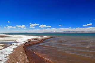
Zhari Namco or Zhari Nanmu or Lake Trari Nam is a salt lake in Tibet, China. It is bounded on the west by Coqên County of Ngari Prefecture, and on the east by Ngamring County of Shigatse Prefecture. Zhari Namco is 996.9 square kilometres (384.9 sq mi), with a drainage area of 15,433.2 square kilometres (5,958.8 sq mi), an elevation of 4,613 metres (15,135 ft), length 54.3 kilometres (33.7 mi) and mean width 18.36 kilometres (11.41 mi). It is located east of Coqên Town in southern Tibet.

Ngangla Rinco, Nganglha Ringtso Lake, or Ang Laren Lake, is a salt lake in Zhongba County in the Shigatse Prefecture of the Tibet Autonomous Region of China. It is located northwest of Renqingxiubu Lake and contains at least 4 islands, the largest of which is about 10 kilometres in length.

Bangda Lake, formerly called Yeshil Kul, is a glacial lake in Ngari Prefecture in the northwest of the Tibet Autonomous Region of China. It lies south of the western Kunlun Mountains, only a few kilometres to the southeast of Guozha Lake . Located at an altitude of 4902 metres, it covers an area of 106 square kilometres with a maximum depth of 21.6 metres and has a drainage basin containing 90 glaciers.

Tong Tso or Dong Co (Chinese: 洞错; pinyin: Dòng Cuò)is a plateau lake in Gêrzê County, Tibet Autonomous Region. The name of lake means "Desolate Lake" in Standard Tibetan. The lake has a total area of about 87.7 square kilometers. Lying at an elevation of 4,396 metres, it is dotted with two islands.
Kunlun Volcanic Group, also known as Ashikule Volcanic Field, is a volcanic field in northwestern Tibet. Eight other volcanic fields are also in the area. The field is within a basin that also contains three lakes.
Dazecuo is one of many inland lakes in Tibet. It is a salt lake on the Tibetan Plateau in Xainza County within Nagqu in the Tibet Autonomous Region of China. It was reported in 2021 that the lake receives "good environmental protection".