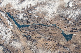
Pangong Tso or Pangong Lake is an endorheic lake spanning eastern Ladakh and West Tibet situated at an elevation of 4,225 m (13,862 ft). It is 134 km (83 mi) long and divided into five sublakes, called Pangong Tso, Tso Nyak, Rum Tso and Nyak Tso. Approximately 50% of the length of the overall lake lies within Tibet administered by China, 40% in Indian-administered Ladakh, and the remaining 10% is disputed and is a de facto buffer zone between India and China. The lake is 5 km (3.1 mi) wide at its broadest point. All together it covers almost 700 km2. During winter the lake freezes completely, despite being saline water. It has a land-locked basin separated from the Indus River basin by a small elevated ridge, but is believed to have been part of the latter in prehistoric times.
Gartok is made of twin encampment settlements of Gar Günsa and Gar Yarsa in the Gar County in the Ngari Prefecture of Tibet. Gar Gunsa served as the winter encampment and Gar Yarsa as the summer encampment. But in British nomenclature, the name Gartok was applied only to Gar Yarsa and the practice continues to date.
Ngari Prefecture or Ali Prefecture is a prefecture of China's Tibet Autonomous Region covering Western Tibet, whose traditional name is Ngari Khorsum. Its administrative centre and largest settlement is the town of Shiquanhe. It is one of the least densely populated areas in the world, with 0.3 people per kilometer.

Rudok, also spelt Rutok and Rutog, more properly Rudok Dzong, is a town that served as the historical capital of the Rudok area in Western Tibet on the frontier with Ladakh. In the 1911 Encyclopædia Britannica, it is described as being "picturesquely situated" on the side of a hill standing isolated in the plain near the east end of Lake Pangong.

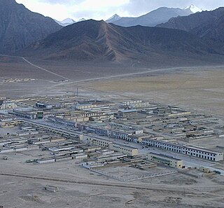
Shiquanhe, known in Tibetan as Sênggêkanbab or Sênggêzangbo, is the main town and administrative seat of Ngari Prefecture, Tibet Autonomous Region, China. Shiquanhe is located on the bank of Sênggê Zangbo, the source stream of the Indus River, close to its confluence with the Gartang River.
Rutog County is a county in Ngari Prefecture, Tibet Autonomous Region, China. The county seat is the new Rutog Town, located some 1,140 km (710 mi) or 700 miles west-northwest of the Tibetan capital, Lhasa. Rutog County shares a border with India.
Gar Günsa, Günsa or Kunsa, is a township consisting of three administrative villages in Gar County in the Ngari Prefecture of the Tibet Autonomous Region of China, viz., Sogmai and Gar Chongsar and Namru The modern Ngari Gunsa Airport is within the township.
The Kongka Pass or Kongka La is a low mountain pass on the Line of Actual Control between India and China in eastern Ladakh. It lies on a spur of the Karakoram range that intrudes into the Chang Chenmo Valley adjacent to the disputed Aksai Chin region. China claimed the location as its border in a 1956 map, and attacked an Indian patrol party in 1959 killing ten policemen and apprehending ten others. Known as the Kongka Pass incident, the event was a milestone in the escalation of the border dispute between the two countries.

Kardze or Garzê, called Ganzi in Chinese, is a town and county seat in Kardze County, Kardze Tibetan Autonomous Prefecture in western Sichuan Province, China. Despite Kardze Prefecture being named after the town, the prefecture capital is Kangding, 365 km to the southeast. As of 2010, Kardze was home to 16,920 inhabitants. Kardze is an ethnic Tibetan township and is located in the historical Tibetan region of Kham. It contains the 15th century Kandze Monastery, home to over 500 Gelugpa monks.
Ali Kunsha Airport, also called Ngari Günsa Airport,, also known as Shiquanhe Airport is a dual-use military and civil airport serving the town of Shiquanhe in Ngari Prefecture, between Gar Chongsar and Sogmai, Günsa Township, Ngari Prefecture, Tibet Autonomous Region. It started operations on 1 July 2010, becoming the fourth civil airport in Tibet after Lhasa, Nyingchi, and Qamdo airports.

Bangda Lake, formerly called Yeshil Kul, is a glacial lake in Ngari Prefecture in the northwest of the Tibet Autonomous Region of China. It lies south of the western Kunlun Mountains, only a few kilometres to the southeast of Guozha Lake . Located at an altitude of 4902 metres, it covers an area of 106 square kilometres with a maximum depth of 21.6 metres and has a drainage basin containing 90 glaciers.

The Khurnak Fort is a ruined fort on the northern shore of Pangong Lake, which spans eastern Ladakh in India and Rutog County in the Tibet region of China. The area of the Khurnak Fort is disputed by India and China, and has been under Chinese administration since 1958.

The Spanggur Gap is a 4,900 metres (16,100 ft) high mountain pass on the Line of Actual Control between the Ladakh union territory of India and the Rutog County, Ngari Prefecture in the Tibet region of China. It is a gap in the mountains to the south of the Pangong Lake. To the east of the gap is the Spanggur Lake.
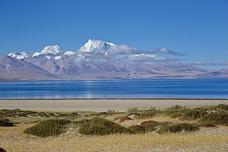
Spanggur Tso, also called Maindong Tso, Mendong Tso, is a saltwater lake in Rutog County in the Tibet Autonomous Region of China, close to the border with Ladakh. India claims a major portion of the lake as its own territory, as part of Ladakh. To the west of the lake lies the Spanggur Gap, a low pass through which the Line of Actual Control runs. To the north is the much larger lake Pangong Tso. Spanggur Tso is at an elevation of 4,305 meters and has an area of 61.6 square kilometres. The lake's average annual temperature is around -4 to -2 °C, and the annual precipitation is 50 to 75 mm. The western portion of the lake is claimed by India.

Gurung Hill is a mountain near the Line of Actual Control between the Indian- and Chinese-administered portions of Ladakh near the village of Chushul and the Spanggur Lake. As of 2020, the Line of Actual Control runs on the north–south ridgeline of Gurung Hill. To the west of Gurung lies the Chushul valley and to the right of it are mountains of Kailash Range forming the basins of the Spanggur Lake and the Pangong Lake in this area.
Tangtse or Drangtse (Tibetan: བྲང་རྩེ, Wylie: brang rtse, THL: drang tsé) is a village in the Leh district of Ladakh, India. It is located in the Durbuk tehsil. Traditionally, it was regarded as the border between the Nubra region to the north and the Pangong region to the south. It was a key halting place on the trade route between Turkestan and Tibet. It was also a site of wars between Ladakh and Tibet.
Gar Tsangpo, also called Gartang or Gar River, is a headwater of the Indus River in the Ngari Prefecture, Tibet, China. It merges with other headwater, Sênggê Zangbo, near the village of Tashigang to form the Indus River. The combined river flows in the same valley and in the same direction as Gar Tsangpo. Thus by physical geography, Gar Tsangpo is the "Indus River". The Tibetans however regard Sênggê Zangbo as the main Indus River, and treat Gar Tsangpo as a tributary.
Chakgang, or Jaggang (Tibetan: ལྕགས་སྒང, Wylie: lcags sgang; Chinese: 甲岗; pinyin: Jiǎ gǎng, often transliterated Jiagang), is a village in the Rutog County, Ngari Prefecture in the Tibet region of China. It is on a wide plain at a major junction in the Maga Zangbo valley where several tributary streams join the river. It is traditionally known for its barley cultivation. The area was used as a base for Chinese military operations in the Demchok sector in the 1962 Sino-Indian War.
Noh, also called Üchang or Wujang (Tibetan: དབུས་བྱང, Wylie: dbus byang, THL: wü jang) is a village in the Rutog County, Ngari Prefecture of the Tibet region of China. It is located on the northern bank of the eastern Pangong Lake, watered by the Doma River (Tsanger-schar). The village is now part of the Domar Township.
Tashigang (Tibetan: བཀྲ་ཤིས་སྒང་, Wylie: bkra shis sgang, THL: tra shi gang, transl. "auspicious hillock"), with a Chinese spelling Zhaxigang , is a village in the Gar County of the Ngari Prefecture, Tibet. The village forms the central district of the Zhaxigang Township. It houses an ancient monastery dating to the 11th century.


