External links
- Annual Viking festival in Mokhovoye (in Russian)
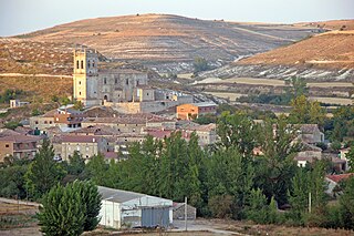
54°56′N20°29′E / 54.933°N 20.483°E Mokhovoye (Russian : Мохово́е; German : Wiskiauten; Lithuanian : Viskiautai) is a rural locality (a settlement) in Zelenogradsky District of Kaliningrad Oblast, Russia, less than 4 km from Zelenogradsk and from the southwestern corner of the Curonian Lagoon. About 320 people live there.
Kaup is the name of a hill immediately north, where a large burial site with Scandinavian grave goods was found. It was important in early medieval history as a likely starting point of the Amber Road to the south.
This is a list of the extreme points of the United Kingdom: the points that are farther north, south, east or west than any other location. Traditionally the extent of the island of Great Britain has stretched "from Land's End to John o' Groats".
Scott Glacier is a glacier, 7 miles (11.3 km) wide and over 20 miles (32 km) long, flowing north-northwest to the Antarctic coast between Denman Glacier and Mill Island. It was discovered by the Western Base Party of the Australasian Antarctic Expedition (1911–1914) under Mawson and named for Capt. Robert F. Scott.
Babine Mountains Provincial Park is a provincial park in British Columbia, Canada, located to the east of the Bulkley River between the town of Smithers and Babine Lake. Established by Order-in-Council as the Babine Mountains Recreation Area in 1984, it was upgraded to park status and its name changed in 1999. It contains approximately 31,465 hectares.

Kerekegyháza is a town in Bács-Kiskun county, in southern Hungary.
Progress is the name of several inhabited localities in Russia.
Bulgakovo is the name of several rural localities in Russia.

Bolshoy Shantar is the main island of the Shantar Islands in the Sea of Okhotsk, Russia; its area is 1,766 square kilometres and it measures about 72 by 49 km. It has a large brackish lake on its north side which is connected to the sea through a narrow passage. Yakshin Bay indents the southwest side of the island.
Saganthit Island is an island in the Mergui Archipelago, Burma (Myanmar). Its area is 257 km2.

Medina de Pomar is a municipality and town located in the province of Burgos, Castile and León, Spain. It is situated 77 km from Bilbao, and 88 km from Burgos, the capital of the province, 8 kilometres from Villarcayo and about 20 km from Espinosa de los Monteros, which are the most important towns in the surroundings of Medina de Pomar.
Tobar is a municipality and town located in the province of Burgos, Spain, within the Castile and León region. It is 35 km northwest of Burgos.

Gaibiel is a in the comarca of Alto Palancia, Castellón, Valencia, Spain.
Antanimenabaka is a town and commune in Madagascar. It belongs to the district of Andilamena, which is a part of Alaotra-Mangoro Region. The population of the commune was estimated to be approximately 15,000 in 2001 commune census.

Expressway S22 or Express Road S22 is a single carriageway express road running from Elbląg to the border with Russia at Grzechotki-Mamonovo, where it connects to a Russian road that continues to Kaliningrad. The border crossing on the road opened in December 2010 and is the largest one on the Polish-Russian border, making S22 the key transport connection between the European Union and the Kaliningrad Oblast.
Oktyabrsky, Oktyabrskaya or Oktyabrskoye is the name of several inhabited localities in Russia.
Torsukattak may refer to the following landforms in Greenland, from north to south:
Mokhovoy, Mokhovaya, or Mokhovoye is the name of several rural localities in Russia.
Lnozavod is the name of several rural localities in Russia.
Mokhovoye is a rural locality in Novokurlakskoye Rural Settlement, Anninsky District, Voronezh Oblast, Russia. The population was 357 as of 2010. There are 6 streets.
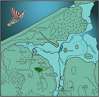
Kaup is a hill on the bank of the Curonian Lagoon, immediately north of the village of Mokhovoye, Kaliningrad Oblast, Russia. It is a large early medieval burial site with Norse grave goods. Kaup has been viewed by historians as an important early medieval emporium and a likely starting point of the Amber Road to the south. The original name of this medieval settlement is uncertain.
Mokhovoye is a rural locality in Baninsky Selsoviet Rural Settlement, Fatezhsky District, Kursk Oblast, Russia. The population as of 2010 is 22.