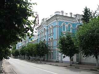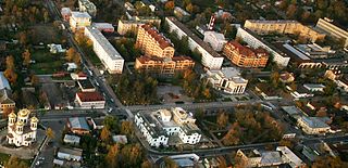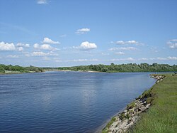
Serpukhov is a city in Moscow Oblast, Russia, located at the confluence of the Oka and the Nara Rivers, 99 kilometers (62 mi) south from Moscow on the Moscow—Simferopol highway. The Moscow—Tula railway passes through Serpukhov. Population: 127,041 (2010 Census); 131,097 (2002 Census); 143,618 (1989 Census).

The Republic of Mordovia is a federal subject of Russia. Its capital is the city of Saransk. As of the 2010 Census, the population of the republic was 834,755. Ethnic Russians (53.4%) and Mordvins (40.0%) account for the majority of the population.

Zvenigorod is an old town in Moscow Oblast, Russia. Population: 16,395 (2010 Census); 12,155 (2002 Census); 15,805 (1989 Census).

Penza is a city and the administrative center of Penza Oblast, Russia, located on the Sura River, 625 kilometers (388 mi) southeast of Moscow. Population: 517,311 (2010 Census); 518,025 (2002 Census); 542,612 (1989 Census).

Tsna is a river in the Tambov and Ryazan oblasts of Russia, the left tributary of the Moksha. The length of the river is 451 km. The catchment area is 21500 km². The height of the mouth is 86 m above sea level.

Kirzhach is a town and the administrative center of Kirzhachsky District in Vladimir Oblast, Russia, located on the Kirzhach River in the west of the oblast, 125 kilometers (78 mi) west of Vladimir and 29 kilometers (18 mi) south of Alexandrov. Population: 29,965 (2010 Census).

Kamenka is a town and the administrative center of Kamensky District in Penza Oblast, Russia, located on the Atmis River 80 kilometers (50 mi) west of Penza, the administrative center of the oblast. Population: 39,577 (2010 Census); 40,712 (2002 Census); 27,235 (1989 Census); 30,000 (1970).

Kovylkino is a town in the Republic of Mordovia, Russia, located 116 kilometers (72 mi) southwest of Saransk on the left bank of the Moksha River. Population: 21,307 (2010 Census); 21,873 (2002 Census); 21,615 (1989 Census).

Kashira is a town and the administrative center of Kashirsky District in Moscow Oblast, Russia, located on the Oka River 115 kilometers (71 mi) south of Moscow. Population: 41,870 (2010 Census); 40,898 (2002 Census); 44,110 (1989 Census).

Gorodishche is a town and the administrative center of Gorodishchensky District in Penza Oblast, Russia, located on the Yulovka River 48 kilometers (30 mi) east of Penza, the administrative center of the oblast. The 2010 census found it had a population of 8096.

Nikolsk is a town and the administrative center of Nikolsky District in Penza Oblast, Russia, located on the Vyrgan River 120 kilometers (75 mi) northeast of Penza, the administrative center of the oblast. Population: 22,471 (2010 Census); 24,061 (2002 Census); 26,871 (1989 Census).

Nizhny Lomov is a town and the administrative center of Nizhnelomovsky District in Penza Oblast, Russia, located on the Lomov River, on the M5 Highway 109 kilometers (68 mi) northwest of Penza, the administrative center of the oblast. Population: 22,678 (2010 Census); 24,249 (2002 Census); 26,648 (1989 Census).

Sursk is a town in Gorodishchensky District of Penza Oblast, Russia, located on the left bank of the Sura River, 92 kilometers (57 mi) east of Penza, the administrative center of the oblast. Population: 7,034 (2010 Census)

Pokrov is a town in Petushinsky District of Vladimir Oblast, Russia, located 5 kilometers (3.1 mi) to the north of the left bank of the Klyazma River, 82 kilometers (51 mi) west of Vladimir, the administrative center of the oblast, and 100 kilometers (62 mi) east of Moscow. Population: 17,756 (2010 Census); 15,920 (2002 Census); 15,988 (1989 Census); 2,925 (1897).

The Mokshas are a Mordvinian ethnic group belonging to the Volgaic branch of the Finno-Ugric peoples who live in the Russian Federation, mostly near the Volga and Moksha rivers, a tributary of the Oka River.

Bekovo is an urban locality and the administrative center of Bekovsky District of Penza Oblast, Russia, located to the extreme south of the oblast on the right bank of the Khopyor River, 154 kilometers (96 mi) from Penza. Population: 6,941 (2010 Census); 6,891 (2002 Census); 7,311 (1989 Census).

Konyshyovsky District is an administrative and municipal district (raion), one of the twenty-eight in Kursk Oblast, Russia. It is located in the northwestern central part of the oblast. The area of the district is 1,135 square kilometers (438 sq mi). Its administrative center is the urban locality of Konyshyovka. Population: 10,594 (2010 Census); 15,155 ; 19,234 (1989 Census). The population of Konyshyovka accounts for 35.4% of the district's total population.

Mokshansky District is an administrative and municipal district (raion), one of the twenty-seven in Penza Oblast, Russia. It is located in the north of the oblast. The area of the district is 2,200 square kilometers (850 sq mi). Its administrative center is the urban locality of Mokshan. Population: 28,033 ; 30,929 (2002 Census); 33,008 (1989 Census). The population of Mokshan accounts for 41.4% of the district's total population.

Gavrilovsky District is an administrative and municipal district (raion), one of the twenty-three in Tambov Oblast, Russia. It is located in the east of the oblast. The district borders with Pichayevsky District in the north, Belinsky District of Penza Oblast in the east, Kirsanovsky District in the south, and with Bondarsky District in the west. The area of the district is 998 square kilometers (385 sq mi). Its administrative center is the rural locality of Gavrilovka 2-ya. Population: 12,032 ; 14,182 (2002 Census); 15,528 (1989 Census). The population of Gavrilovka 2-ya accounts for 22.2% of the district's total population.

Belyovsky District is an administrative district (raion), one of the twenty-three in Tula Oblast, Russia. Within the framework of municipal divisions, it is incorporated as Belyovsky Municipal District. It is located in the west of the oblast. The area of the district is 1,190 square kilometers (460 sq mi). Its administrative center is the town of Belyov. Population: 20,952 ; 24,912 (2002 Census); 30,124 (1989 Census). The population of Belyov accounts for 66.4% of the district's total population.


