Related Research Articles
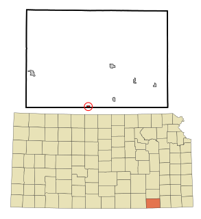
Chautauqua County is a county located in Southeast Kansas, United States. As of the 2020 census, the county population was 3,379. Its county seat and most populous city is Sedan. Chautauqua County is named for Chautauqua County, New York, the birthplace of Edward Jaquins, a Kansas politician who was instrumental in getting the county established.

Chautauqua is a city in Chautauqua County, Kansas, United States. As of the 2010 census, the city population was 111.
Elgin is a city in Chautauqua County, Kansas, United States, on the state line with Oklahoma. As of the 2010 census, the city population was 89. The south edge of the city is the Kansas-Oklahoma state border.

Peru is a city in Chautauqua County, Kansas, United States. As of the 2010 census, the city population was 139.
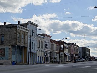
Sedan is the county seat of and the largest city in Chautauqua County, Kansas, United States. As of the 2010 census, the city population was 1,124.

Southeast Kansas is a region of the U.S. state of Kansas. It can be roughly defined by Woodson County in the northwest, Bourbon County in the northeast, Cherokee County in the southeast, and Montgomery County in the southwest. Geographically it is dominated by a broad rolling landscape located between the Flint Hills to the west and includes the Ozarks to the southeast. Some notable towns there include Pittsburg, Parsons, Coffeyville, Independence, Chanute, Fort Scott, and Iola.
The four-state area or quad-state area, is the area where the states of Arkansas, Kansas, Missouri, and Oklahoma almost touch: Arkansas and Kansas have no boundary. The Tulsa, Oklahoma; Joplin, Missouri; and Fayetteville–Springdale–Rogers, Arkansas, metropolitan areas are located within the region. Notable cities and towns in the area are Tulsa and Miami, Oklahoma; Pittsburg, Kansas; Joplin, Springfield, and Monett, Missouri; and Fayetteville, Springdale, Rogers, and Bentonville, Arkansas.

Rosalia is an unincorporated community in Butler County, Kansas, United States. As of the 2020 census, the population of the community and nearby areas was 149. It is located approximately 12 miles (19 km) east of El Dorado.
Floral is an unincorporated community in Cowley County, Kansas, United States.
Grand Summit is an unincorporated community in Cowley County, Kansas, United States.
Hale is an unincorporated community in Salt Creek Township, Chautauqua County, Kansas, United States.
Hooser is an unincorporated community in Dexter Township, Cowley County, Kansas, United States. It is located at 37°08′18″N96°37′48″W.
Vinton is an unincorporated community in Cowley County, Kansas, United States. It is located at 37°06′20″N96°49′31″W.
Wilmot is an unincorporated community in Cowley County, Kansas, United States. It is located at 37°22′34″N96°52′33″W.
Ivanpah is a ghost town in Greenwood County, Kansas, United States.
Utopia is a ghost town in Greenwood County, Kansas, United States.
Midian is an unincorporated community in Butler County, Kansas, United States.
Cloverdale is an unincorporated community in Chautauqua County, Kansas, United States.
Grafton is an unincorporated community in Chautauqua County, Kansas, United States.
Rogers is an unincorporated community in Chautauqua County, Kansas, United States.
References
- ↑ "Monett, Kansas", Geographic Names Information System , United States Geological Survey
- ↑ "Kansas Post Offices, 1828-1961 (archived)". Kansas Historical Society. Archived from the original on October 9, 2013. Retrieved 6 June 2014.
{{cite web}}: CS1 maint: unfit URL (link)
