Sedan, Kansas

Last updated

Sedan, Kansas
Sedan, Kansas.jpg
Downtown Sedan (2013)
Chautauqua County Kansas Incorporated and Unincorporated areas Sedan Highlighted.svg
Location within Chautauqua County and Kansas
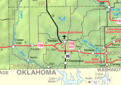
Map of Chautauqua Co, Ks, USA.png
Coordinates: 37°07′42″N96°11′05″W / 37.12833°N 96.18472°W / 37.12833; -96.18472 [1]
Country United States
State Kansas
County Chautauqua
Founded1871
Incorporated 1876
Named for Battle of Sedan
Area
[2]
  Total0.82 sq mi (2.13 km2)
  Land0.82 sq mi (2.13 km2)
  Water0.00 sq mi (0.00 km2)
Elevation
[1]
863 ft (263 m)
Population
 (2020) [3]
  Total1,000
  Density1,200/sq mi (470/km2)
Time zone UTC-6 (CST)
  Summer (DST) UTC-5 (CDT)
ZIP code
67361
Area code 620
FIPS code 20-63750
GNIS ID 2396569 [1]
Website cityofsedan.com

Sedan is the county seat of and the largest city in Chautauqua County, Kansas, United States. [1] As of the 2020 census, the population of the city was 1,000. [3]

Contents

History

Sedan was founded in 1871. [4] The city was named in commemoration of the 1870 Battle of Sedan. [5] [6] In 1875, it was chosen as the county seat. [7] Sedan was incorporated as a city in 1876. [8]

Geography

According to the United States Census Bureau, the city has a total area of 0.81 square miles (2.10 km2), all of it land. [9]

Climate

The climate in this area is characterized by hot, humid summers and generally mild to cool winters. According to the Köppen Climate Classification system, Sedan has a humid subtropical climate, abbreviated "Cfa" on climate maps. [10]

Climate data for Sedan, Kansas, 1991–2020 normals, extremes 1893–present
MonthJanFebMarAprMayJunJulAugSepOctNovDecYear
Record high °F (°C)80
(27)
89
(32)
95
(35)
99
(37)
100
(38)
108
(42)
118
(48)
116
(47)
113
(45)
101
(38)
88
(31)
81
(27)
118
(48)
Mean maximum °F (°C)69.4
(20.8)
74.2
(23.4)
80.5
(26.9)
86.5
(30.3)
89.8
(32.1)
94.3
(34.6)
100.4
(38.0)
101.3
(38.5)
96.7
(35.9)
87.6
(30.9)
78.4
(25.8)
69.5
(20.8)
102.8
(39.3)
Average high °F (°C)45.5
(7.5)
50.5
(10.3)
60.1
(15.6)
69.5
(20.8)
77.2
(25.1)
85.7
(29.8)
91.5
(33.1)
91.3
(32.9)
83.1
(28.4)
72.0
(22.2)
59.3
(15.2)
48.1
(8.9)
69.5
(20.8)
Daily mean °F (°C)33.6
(0.9)
37.8
(3.2)
47.2
(8.4)
56.7
(13.7)
65.9
(18.8)
75.0
(23.9)
80.1
(26.7)
79.1
(26.2)
70.6
(21.4)
58.9
(14.9)
46.7
(8.2)
36.6
(2.6)
57.4
(14.1)
Average low °F (°C)21.6
(−5.8)
25.1
(−3.8)
34.4
(1.3)
44.0
(6.7)
54.5
(12.5)
64.2
(17.9)
68.8
(20.4)
66.8
(19.3)
58.1
(14.5)
45.8
(7.7)
34.1
(1.2)
25.1
(−3.8)
45.2
(7.3)
Mean minimum °F (°C)5.1
(−14.9)
10.0
(−12.2)
18.1
(−7.7)
30.2
(−1.0)
40.3
(4.6)
54.3
(12.4)
60.4
(15.8)
57.6
(14.2)
44.2
(6.8)
30.2
(−1.0)
19.0
(−7.2)
9.2
(−12.7)
1.3
(−17.1)
Record low °F (°C)−27
(−33)
−24
(−31)
−7
(−22)
11
(−12)
25
(−4)
40
(4)
47
(8)
42
(6)
30
(−1)
12
(−11)
3
(−16)
−15
(−26)
−27
(−33)
Average precipitation inches (mm)1.29
(33)
1.73
(44)
2.80
(71)
4.30
(109)
6.15
(156)
5.58
(142)
3.82
(97)
3.50
(89)
3.52
(89)
3.84
(98)
2.15
(55)
1.86
(47)
40.54
(1,030)
Average snowfall inches (cm)2.4
(6.1)
2.2
(5.6)
1.7
(4.3)
0.1
(0.25)
0.0
(0.0)
0.0
(0.0)
0.0
(0.0)
0.0
(0.0)
0.0
(0.0)
0.0
(0.0)
0.3
(0.76)
2.6
(6.6)
9.3
(23.61)
Average precipitation days (≥ 0.01 in)5.66.18.39.611.09.48.07.77.17.26.15.891.9
Average snowy days (≥ 0.1 in)1.81.20.70.10.00.00.00.00.00.00.31.25.3
Source 1: NOAA [11]
Source 2: National Weather Service [12]

Demographics

Historical population
CensusPop.Note
1880 665
1890 97045.9%
1900 1,06710.0%
1910 1,21113.5%
1920 1,88555.7%
1930 1,776−5.8%
1940 1,9489.7%
1950 1,640−15.8%
1960 1,6772.3%
1970 1,555−7.3%
1980 1,5791.5%
1990 1,306−17.3%
2000 1,3422.8%
2010 1,124−16.2%
2020 1,000−11.0%
U.S. Decennial Census

2010 census

As of the census [13] of 2010, there were 1,124 people, 482 households, and 269 families residing in the city. The population density was 1,387.7 inhabitants per square mile (535.8/km2). There were 615 housing units at an average density of 759.3 per square mile (293.2/km2). The racial makeup of the city was 91.3% White, 0.4% African American, 2.8% Native American, 0.1% Asian, 0.2% Pacific Islander, 2.2% from other races, and 3.0% from two or more races. Hispanic or Latino of any race were 5.2% of the population.

There were 482 households, of which 25.5% had children under the age of 18 living with them, 40.9% were married couples living together, 11.0% had a female householder with no husband present, 3.9% had a male householder with no wife present, and 44.2% were non-families. 40.5% of all households were made up of individuals, and 19.1% had someone living alone who was 65 years of age or older. The average household size was 2.19 and the average family size was 2.86.

The median age in the city was 48.1 years. 21.6% of residents were under the age of 18; 6.7% were between the ages of 18 and 24; 18.2% were from 25 to 44; 26.5% were from 45 to 64; and 26.8% were 65 years of age or older. The gender makeup of the city was 47.3% male and 52.7% female.

2000 census

As of the census [14] of 2000, there were 1,342 people, 560 households, and 346 families residing in the city. The population density was 1,712.6 inhabitants per square mile (661.2/km2). There were 652 housing units at an average density of 832.1 per square mile (321.3/km2). The racial makeup of the city was 93.44% White, 0.52% African American, 3.35% Native American, 0.22% Asian, 0.15% Pacific Islander, 0.45% from other races, and 1.86% from two or more races. Hispanic or Latino of any race were 2.09% of the population.

There were 560 households, out of which 23.9% had children under the age of 18 living with them, 48.9% were married couples living together, 10.0% had a female householder with no husband present, and 38.2% were non-families. 35.2% of all households were made up of individuals, and 18.4% had someone living alone who was 65 years of age or older. The average household size was 2.25 and the average family size was 2.90.

In the city, the population was spread out, with 23.0% under the age of 18, 7.9% from 18 to 24, 21.3% from 25 to 44, 19.8% from 45 to 64, and 27.9% who were 65 years of age or older. The median age was 43 years. For every 100 females, there were 83.8 males. For every 100 females age 18 and over, there were 80.6 males.

The median income for a household in the city was $24,324, and the median income for a family was $32,574. Males had a median income of $21,490 versus $19,261 for females. The per capita income for the city was $14,153. About 6.8% of families and 11.1% of the population were below the poverty line, including 13.0% of those under age 18 and 9.5% of those age 65 or over.

Education

Sedan is served by Chautauqua County USD 286 public school district, and its Sedan Jr/Sr High School is located in Sedan. Schools in Chautauqua County were consolidated through school unification. [15]

Prior to school unification, the Sedan Blue Devils won the Kansas State High School class B baseball championship in 1973 and 2011. [16]

Area attractions

Notable people

Twin City

Sedan, Kansas has a partnership with the village of Sedan, France. Sedan is located in the Ardennes in Northern France.

See also

Related Research Articles

<span class="mw-page-title-main">Chautauqua County, Kansas</span> County in Kansas, United States

Chautauqua County is a county located in Southeast Kansas, United States. Its county seat and most populous city is Sedan. As of the 2020 census, the county population was 3,379. The county is named for Chautauqua County, New York, the birthplace of Edward Jaquins, a Kansas politician who was instrumental in getting the county established.

<span class="mw-page-title-main">Cedar Vale, Kansas</span> City in Chautauqua County, Kansas

Cedar Vale is a city in Chautauqua County, Kansas, United States. As of the 2020 census, the population of the city was 476.

<span class="mw-page-title-main">Chautauqua, Kansas</span> City in Chautauqua County, Kansas

Chautauqua is a city in Chautauqua County, Kansas, United States. As of the 2020 census, the population of the city was 108.

<span class="mw-page-title-main">Elgin, Kansas</span> City in Chautauqua County, Kansas

Elgin is a city in Chautauqua County, Kansas, United States. As of the 2020 census, the population of the city was 60. The south edge of the city is the Kansas-Oklahoma state line.

<span class="mw-page-title-main">Peru, Kansas</span> City in Chautauqua County, Kansas

Peru is a city in Chautauqua County, Kansas, United States. As of the 2020 census, the population of the city was 101.

<span class="mw-page-title-main">Wakefield, Kansas</span> City in Clay County, Kansas

Wakefield is a city in Clay County, Kansas, United States. As of the 2020 census, the population of the city was 858.

<span class="mw-page-title-main">Gridley, Kansas</span> City in Coffey County, Kansas

Gridley is a city in Coffey County, Kansas, United States. As of the 2020 census, the population of the city was 313.

<span class="mw-page-title-main">LeRoy, Kansas</span> City in Coffey County, Kansas

LeRoy is a city in Coffey County, Kansas, United States. As of the 2020 census, the population of the city was 451.

<span class="mw-page-title-main">Wilmore, Kansas</span> City in Comanche County, Kansas

Wilmore is a city in Comanche County, Kansas, United States. As of the 2020 census, the population of the city was 37.

<span class="mw-page-title-main">Atlanta, Kansas</span> City in Cowley County, Kansas

Atlanta is a city in Cowley County, Kansas, United States. As of the 2020 census, the population of the city was 168.

<span class="mw-page-title-main">McCune, Kansas</span> City in Crawford County, Kansas

McCune is a city in Crawford County, Kansas, United States. As of the 2020 census, the population of the city was 370.

<span class="mw-page-title-main">Williamsburg, Kansas</span> City in Franklin County, Kansas

Williamsburg is a city in Franklin County, Kansas, United States. As of the 2020 census, the population of the city was 390.

<span class="mw-page-title-main">Gove City, Kansas</span> City in Gove County, Kansas

Gove City, more commonly known as Gove, is a city in and the county seat of Gove County, Kansas, United States. As of the 2020 census, the population of the city was 80.

<span class="mw-page-title-main">Barnard, Kansas</span> City in Lincoln County, Kansas

Barnard is a city in Lincoln County, Kansas, United States. As of the 2020 census, the population of the city was 64.

<span class="mw-page-title-main">Mound City, Kansas</span> City and County seat in Kansas, United States

Mound City is a city in and the county seat of Linn County, Kansas, United States. As of the 2020 census, the population of the city was 647.

<span class="mw-page-title-main">Brownell, Kansas</span> City in Ness County, Kansas

Brownell is a city in Ness County, Kansas, United States. As of the 2020 census, the population of the city was 23.

<span class="mw-page-title-main">Utica, Kansas</span> City in Ness County, Kansas

Utica is a city in Ness County, Kansas, United States. As of the 2020 census, the population of the city was 99.

<span class="mw-page-title-main">Emmett, Kansas</span> City in Pottawatomie County, Kansas

Emmett is a city in Pottawatomie County, Kansas, United States. As of the 2020 census, the population of the city was 170.

<span class="mw-page-title-main">Johnson City, Kansas</span> City in Stanton County, Kansas

Johnson City is a city in and the county seat of Stanton County, Kansas, United States. As of the 2020 census, the population of the city was 1,464.

<span class="mw-page-title-main">Toronto, Kansas</span> City in Woodson County, Kansas, United States

Toronto is a city in Woodson County, Kansas, United States, along the Verdigris River. As of the 2020 census, the population of the city was 206.

References

  1. 1 2 3 4 U.S. Geological Survey Geographic Names Information System: Sedan, Kansas
  2. "2019 U.S. Gazetteer Files". United States Census Bureau. Retrieved July 24, 2020.
  3. 1 2 "Profile of Sedan, Kansas in 2020". United States Census Bureau. Archived from the original on May 23, 2022. Retrieved May 23, 2022.
  4. Kansas State Historical Society (1916). Biennial Report of the Board of Directors of the Kansas State Historical Society. Kansas State Printing Plant. pp.  154.
  5. Moyer, Armond; Moyer, Winifred (1958). The origins of unusual place-names. Keystone Pub. Associates. p. 117.
  6. https://www.kancoll.org/books/cutler/chautauqua/chautauqua-co-p1.html
  7. Blackmar, Frank Wilson (1912). Kansas: A Cyclopedia of State History, Volume 2. Standard Publishing Company. pp.  661.
  8. Blackmar, Frank Wilson (1912). Kansas: A Cyclopedia of State History, Volume 2. Standard Publishing Company. pp.  661.
  9. "US Gazetteer files 2010". United States Census Bureau. Archived from the original on July 2, 2012. Retrieved July 6, 2012.
  10. Climate Summary for Sedan, Kansas
  11. "U.S. Climate Normals Quick Access – Station: Sedan, KS". National Oceanic and Atmospheric Administration. Retrieved May 2, 2023.
  12. "NOAA Online Weather Data – NWS Wichita". National Weather Service. Retrieved May 2, 2023.
  13. "U.S. Census website". United States Census Bureau . Retrieved July 6, 2012.
  14. "U.S. Census website". United States Census Bureau . Retrieved January 31, 2008.
  15. "Home Page". Chautauqua County USD 286. February 13, 2023.
  16. "Baseball". KSHSAA. Retrieved January 6, 2017.
  17. Butcher Falls; Kansas Travel.

Further reading