The use of rock-cut cave tombs in the region began in the early Canaanite period, from 3100–2900 BCE. The custom lapsed a millennium, however, before re-emerging in the earliest Israelite tombs, dating to the 9th century BCE in Jerusalem. The use of rock-cut tombs reached its peak in the 8th and 7th centuries BCE, before rapidly declining and eventually falling out of use in the 6th century BCE in some regions. It reappeared during the Second Temple period and continued into the Late Roman and Byzantine periods.

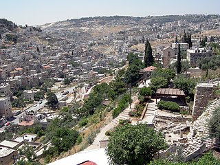
The City of David, known locally mostly as Wadi Hilweh, is the name given to an archaeological site considered by most scholars to be the original settlement core of Jerusalem during the Bronze and Iron Ages. It is situated on southern part of the eastern ridge of ancient Jerusalem, west of the Kidron Valley and east of the Tyropoeon Valley, to the immediate south of the Temple Mount.
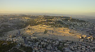
The Mount of Olives or Mount Olivet is a mountain ridge in East Jerusalem, east of and adjacent to Jerusalem's Old City. It is named for the olive groves that once covered its slopes. The southern part of the mount was the Silwan necropolis, attributed to the elite of the ancient Kingdom of Judah. The western slopes of the mount, those facing Jerusalem, have been used as a Jewish cemetery for over 3,000 years and holds approximately 150,000 graves, making it central in the tradition of Jewish cemeteries. Atop the hill lies the Palestinian neighbourhood of At-Tur, a former village that is now part of East Jerusalem.

Uzziah, also known as Azariah, was the tenth king of the ancient Kingdom of Judah, and one of Amaziah's sons. Uzziah was 16 when he became king of Judah and reigned for 52 years. The first 24 years of his reign were as a co-regent with his father, Amaziah.

Israel Finkelstein is an Israeli archaeologist, professor emeritus at Tel Aviv University and the head of the School of Archaeology and Maritime Cultures at the University of Haifa. Finkelstein is active in the archaeology of the Levant and is an applicant of archaeological data in reconstructing biblical history. Finkelstein is the current excavator of Megiddo, a key site for the study of the Bronze and Iron Ages in the Levant.

Gezer, or Tel Gezer, in Arabic: تل الجزر – Tell Jezar or Tell el-Jezari is an archaeological site in the foothills of the Judaean Mountains at the border of the Shfela region roughly midway between Jerusalem and Tel Aviv. It is now an Israeli national park. In the Hebrew Bible, Gezer is associated with Joshua and Solomon.
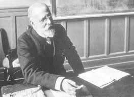
Charles Simon Clermont-Ganneau was a noted French Orientalist and archaeologist.

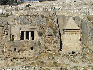
The Tomb of Absalom, also called Absalom's Pillar, is an ancient monumental rock-cut tomb with a conical roof located in the Kidron Valley in Jerusalem, a few metres from the Tomb of Zechariah and the Tomb of Benei Hezir. Although traditionally ascribed to Absalom, the rebellious son of King David of Israel, recent scholarship has dated it to the 1st century AD.

The LMLK seal appears on the handles of several large storage jars from the Kingdom of Judah, where it was first issued during the reign of Hezekiah around 700 BCE. Seals bearing these four Hebrew letters have been discovered primarily on unearthed artifacts in and around Jerusalem, with some in northern Israel. Several complete jars were found in situ at the ancient city of Lachish, where they were buried underneath a destruction layer caused by Sennacherib, who reigned over the Neo-Assyrian Empire from 705 BCE to 681 BCE. While none of the original stamp seals have been found, some 2,000 impressions made by at least 21 seal types have been published. The iconography of the two- and four-winged symbols are representative of royal symbols whose meaning "was tailored in each kingdom to the local religion and ideology".

The Siloam inscription, Silwan inscription or Shiloah inscription, known as KAI 189, is a Hebrew inscription found in the Siloam tunnel which brings water from the Gihon Spring to the Pool of Siloam, located in the City of David in East Jerusalem neighborhood of Silwan. The inscription records the construction of the tunnel, which has been dated to the 8th century BC on the basis of the writing style. It is the only known ancient inscription from ancient Israel and Judah which commemorates a public construction work, despite such inscriptions being commonplace in Egyptian and Mesopotamian archaeology.
Kidron Valley is the modern name of the valley originating slightly northeast of the Old City of Jerusalem, which then separates the Temple Mount from the Mount of Olives, and ending at the Dead Sea. Beyond Jerusalem it continues in a general south-easterly direction through the Judean desert in the West Bank, reaching the Dead Sea near the settlement of Ovnat, and descending 4,000 feet (1,200 m) along its 20-mile (32 km) course.

Rock-cut architecture is the creation of structures, buildings, and sculptures by excavating solid rock where it naturally occurs. Intensely laborious when using ancient tools and methods, rock-cut architecture was presumably combined with quarrying the rock for use elsewhere. In India and China, the terms cave and cavern are often applied to this form of man-made architecture, but caves and caverns that began in natural form are not considered to be rock-cut architecture even if extensively modified. Although rock-cut structures differ from traditionally built structures in many ways, many rock-cut structures are made to replicate the facade or interior of traditional architectural forms. Interiors were usually carved out by starting at the roof of the planned space and then working downward. This technique prevents stones falling on workers below. The three main uses of rock-cut architecture were temples, tombs, and dwellings.

Hawara is an archaeological site of Ancient Egypt, south of the site of Crocodilopolis at the entrance to the depression of the Fayyum oasis. It is the site of a pyramid built by Pharaoh Amenemhat III of the 12th dynasty in the 19th century B.C.

David Ussishkin is an Israeli archaeologist and professor emeritus of archaeology.

Gabriel Barkay is an Israeli archaeologist.

Silwan or Siloam is a predominantly Palestinian district in East Jerusalem, on the southeastern outskirts of the current Old City of Jerusalem.
The King's Garden is a location mentioned in the Hebrew Bible, and associated by biblical archaeologists with the Al-Bustan neighbourhood in the Silwan area of East Jerusalem.
The Royal Steward Inscription, known as KAI 191, is an important Proto-Hebrew inscription found in the village of Silwan outside Jerusalem in 1870. After passing through various hands, the inscription was purchased by the British Museum in 1871.

The Silwan necropolis is the remains of a rock-cut cemetery assumed to have been used by the highest-ranking officials residing in Jerusalem. Its tombs were cut between the 9th and 7th centuries BC. It is situated on the rocky eastern slope of the Kidron Valley, facing the oldest part of Jerusalem. Part of the Palestinian district of Silwan was later built atop the necropolis.

Biblical Egypt, or Mizraim, is a theological term used by historians and scholars to differentiate between Ancient Egypt as it is portrayed in Judeo-Christian texts and what is known about the region based on archaeological evidence. Along with Canaan, Egypt is one of the most commonly mentioned locations in the Bible, and its people, the Egyptians, play important roles in the story of the Israelites. Although interaction between Egypt and nearby Semitic-speaking peoples is attested in archaeological sources, they do not otherwise corroborate the biblical account.


