
The Graian Alps are a mountain range in the western part of the Alps.
This article lists the principal mountain passes and tunnels in the Alps, and gives a history of transport across the Alps.

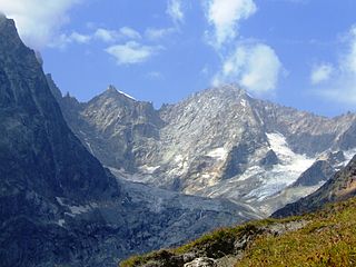
The Aiguille de Bionnassay is a mountain in the Mont Blanc massif of the Alps in France and Italy. It has been described as "one of the most attractive satellite peaks of Mont Blanc", and is located on its western side. The mountain's south and east ridges form the frontier between the two countries, and its summit is a knife-edge crest of snow and ice. Reaching it via any route provides a "splendid and serious snow and ice climb".

The Grand Combin is a mountain massif in the western Pennine Alps in the canton of Valais. At a height of 4,314 metres (14,154 ft) the summit of Combin de Grafeneire is one of the highest peaks in the Alps and the second most prominent of the Pennine Alps. The Grand Combin is also a large glaciated massif consisting of several summits, among which three are above 4000 metres. The highest part of the massif is wholly in Switzerland, although the border with Italy lies a few kilometres south.

Mont Cenis is a massif and a pass in Savoie (France), which forms the limit between the Cottian and Graian Alps.

The Alps cover a large area. This article describes the delimitation of the Alps as a whole and of subdivisions of the range, follows the course of the main chain of the Alps and discusses the lakes and glaciers found in the region.

The Susa Valley is a valley in the Metropolitan City of Turin, Piedmont region of northern Italy, located between the Graian Alps in the north and the Cottian Alps in the south. It is one of the longest valleys of the Italian Alps. It extends over 50 kilometres (31 mi) in an east-west direction from the French border to the outskirts of Turin. The valley takes its name from the city of Susa which lies in the valley. The Dora Riparia river, a tributary of the Po, flows through the valley.

The Aiguille d'Argentière is a mountain in the Mont Blanc massif on the border between France and Switzerland.
The Col Ferret is an Alpine pass between the canton of Valais and the Aosta Valley. It is crossed by the route of the Tour du Mont Blanc. Close to it stands the Petit Col Ferret, at an elevation of 2,490 metres (8,170 ft), which separates the Mont Blanc Massif from the Pennine Alps.

Mont Gelé is a mountain of the Pennine Alps, part of the Municipality Riddes and overlooking Verbier in the Swiss canton of Valais. Located on the range north of Mont Fort, its summit is the tripoint between the municipalities of Bagnes, Riddes and Nendaz. It is one of the two mountains named Mont Gelé in the valley of Bagnes, the other being located on the Italian border.

Mont Gelé (3,518 m) is a mountain of the Pennine Alps, located on the border between Switzerland and Italy. It lies between the valleys of Bagnes and Valpelline, on the main Alpine watershed. It overlooks the Fenêtre de Durand from the east side.

Mont Gond is a mountain of the Bernese Alps, overlooking Derborence in Valais. It is located between the Diablerets and the Rhone valley.
The Pointe de Drône is a mountain of the Pennine Alps, located on the border between Italy and Switzerland. It lies west of the Great St. Bernard Pass.

Val Ferret is the name shared by two valleys separated by the Col Ferret, a pass on the border between Italy and Switzerland. The valleys lie southeast of Mont Blanc Massif. The Swiss valley drains northeast towards Orsières and on into the Rhône basin; whereas the Italian valley drains southwest towards Courmayeur and on into the Po basin.

Mont Tendre is a mountain of the Jura, located between the valley of Joux and the basin of Lake Geneva in the canton of Vaud. With an elevation of 1,679 metres above sea level, it is the highest summit of the Swiss portion of the Jura Mountains and, therefore, the highest summit of Switzerland outside the Alps. It is also the most isolated mountain of the canton. It is found in the community of Montricher.
The Petit Col Ferret is an Alpine pass between the canton of Valais and the Aosta Valley.
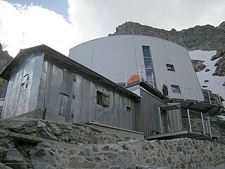
The Gonella Hut is a high altitude mountain hut in the Aosta Valley in the Mont Blanc massif area of the Alps. It lies at an altitude of 3071 metres, above Val Veny near Courmayeur in Italy. The refuge is located on the Italian 'normal route' to Mont Blanc.

The Col de Balme is a high mountain pass of the Alps, located on the border between Switzerland and France. It connects Trient in the Swiss canton of Valais to Argentière in the French department of Haute-Savoie. The pass lies between the summits of Tête de Balme and Les Grandes Otanes.
Mont Mort is a mountain of the Pennine Alps, located on the border between Switzerland and Italy. It is located on the main chain of the Alps, just south-east of the Great St Bernard Pass.

The France–Italy border is 515 km long. It runs from the Alps in the north, a region in which it passes over Mont Blanc, down to the Mediterranean coast in the south. Three national parks are located along the border: Vanoise National Park and Mercantour National Park on the French side and Gran Paradiso National Park on the Italian side.
