Monte Politri

Last updated
Monte Politri
Bric Rosso
Bric rosso da fea nera a dx truc cialabrie a sin pian paris malanotte cristalliera.jpg
The mountain as seen from Fea Nera
Highest point
Elevation 3,026 m (9,928 ft) [1]
Prominence 313 m (1,027 ft) [2] [1]
Parent peak Monte Albergian
Listing Alpine mountains above 3000 m
Coordinates 44°59′28.28″N07°01′7.36″E / 44.9911889°N 7.0187111°E / 44.9911889; 7.0187111 Coordinates: 44°59′28.28″N07°01′7.36″E / 44.9911889°N 7.0187111°E / 44.9911889; 7.0187111
Geography
Alps location map.png
Red triangle with thick white border.svg
Monte Politri
Alps
Location Piedmont, Italy
Parent range Cottian Alps
Climbing
Easiest route Scrambling

Monte Politri or Bric Rosso [3] is a 3,026 m a.s.l. mountain of the Cottian Alps, located in Italy.

Contents

Geography

The mountain is located on the ridge between Val Chisone (North) and Valle Germanasca (South). Going West an unnamed saddle at 2863 divides Monte Politri from Fea Nera (2,946 m a.s.l.), while going East another saddle at 2,880 m separates it from Truc Cialabrie (2,936 m a.s.l.). [1]

Administratively the north face of the mountain belongs to the Fenestrelle municipality ( comune ) and the South one to Massello municipality, [1] both in the Metropolitan City of Turin. In clear days its summit offers a good view of Western Alps, a little limited towards NW by the neighbouring Monte Albergian.

SOIUSA classification

According to SOIUSA (International Standardized Mountain Subdivision of the Alps) the mountain can be classified in the following way: [4]

Access to the summit

The usual route to Monte Politri starts from Colle dell'Albergian (2,713 m), which can be reached by waymarked footpath starting either from Balsiglia (Valle Germanasca) or from Laux (Val Chisone. While long from both these starting points, the route does not require alpine skills [3] but just scrambling. In the Italian scale of hiking difficulty is rated EE (Escursionisti Esperti, namely suitable for expert hikers). [5] Several climbing routes were described around the mountain, ranging from PD- to D+ grade. [3]

Related Research Articles

Valle Germanasca

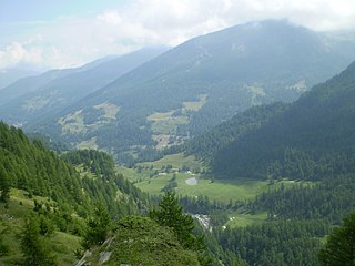
The Valle Germanasca is a valley in the Metropolitan City of Turin, Piedmont, north-western Italy run by the Germanasca stream, a right affluent of the Chisone.

Mont dAmbin Mountain in the Cottian Alps on the French-Italian border

Mont d'Ambin or Rocca d'Ambin is a mountain on the border of Savoie, France and of the Province of Turin, Italy. It lies in the Ambin group of the Cottian Alps. On the Italian side, it commands the view of the Val di Susa. It has an elevation of 3,378 metres (11,083 ft) above sea level.

Monte Colombano

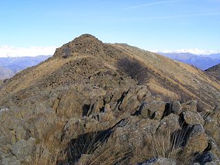
Monte Colombano is a mountain in the Alpi di Lanzo, a sub-group of the Graian Alps, with an elevation of 1,658 m.

Pointe de Paumont

Pointe de Paumont or Cima del Vallone is a mountain of Savoie, France and of the Province of Turin, Italy. It lies in the Cottian Alps range. It has an elevation of 3,171 metres above sea level.

Punta Bagnà

Punta Bagnà or Cime du Grand Vallon is a mountain of Savoie, France and of the Province of Turin, Italy. It lies in the Cottian Alps range. It has an elevation of 3,129 metres above sea level.

Punta Sommeiller

Punta Sommeiller or Pointe Sommeiller is a mountain of the Province of Turin, Italy and of Savoie, France. It lies in the Cottian Alps range. It has an elevation of 3,333 metres (10,935 ft) above sea level.

Rognosa dEtiache

Rognosa d'Etiache or Rognosa d'Étache is a mountain in the Cottian Alps on the border of Turin, Italy, and Savoie, France. It has an elevation of 3,382 metres above sea level.

Monte Orsiera

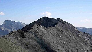
Monte Orsiera is a mountain in the Cottian Alps belonging to the Province of Turin (Italy).

Monte Cresto

Monte Cresto (2,548 m) is the third highest peak of the Province of Biella after Monte Mars (2,600 m) and Monte Bo (2,556 m).

Bric Ghinivert Mountain in Italy

Bric Ghinivert or Eiminàl is a mountain of the Cottian Alps located in Italy.

Monte Albergian Mountain in Italy

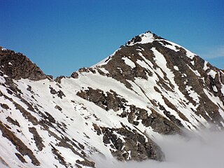
Monte Albergian is a 3,041 m a.s.l. mountain of the Cottian Alps, located in Italy. A battalion of 3rd Alpini Regiment, which during World War I earned a Silver Medal of Military Valor, was named after Monte Albergian.

Punta Tempesta Mountain in Italy

Punta Tempesta is a 2,679 m a.s.l. mountain of the Cottian Alps, located in Italy.

Monte Monega Mountain in Italy

Monte Monega is a 1,882-metre (6,175 ft) mountain of the Ligurian Alps, in Italy.

Punta Merciantaira

The Punta Merciantaira or Grand Glaiza is a 3,293 metres high mountain of the Cottian Alps.

Grand Queyron

The Gran Queyron or Grand Queyron is a 3,060 metres high mountain of the Cottian Alps.

Punta Bes Mountain in Italy

The Punta Bes is a 3,177 metres high mountain belonging to the Italian side of Graian Alps.

Punta Nera

The Punta Nera is a mountain of Savoie (France) and of the Province of Turin (Italy). It lies in the Cottian Alps range. It has an elevation of 3,047 metres above sea level.

Punta Cornour Mountain in Italy

The Punta Cornour is a 2,868 metres high mountain on the Italian side of the Cottian Alps.

Cima Ciantiplagna Mountain in Italy

The Cima Ciantiplagna is a mountain in the Cottian Alps belonging to the Province of Turin (Italy).

Monte Birrone Mountain in Italy

The Monte Birrone is a 2,131-metre (6,991 ft) high mountain in the Cottian Alps, belonging to the Italian province of Cuneo.

References

  1. 1 2 3 4 "Geoportale Nazionale - carta IGM 1:25.000". Istituto Geografico Militare . Retrieved 2017-02-22.
  2. Key col: Colle dell'Albergian, 2713 m
  3. 1 2 3 Ferreri, Eugenio (1982). Alpi Cozie cenrali. C.A.I./T.C.I. pp. 244–246.
  4. Marazzi, Sergio (2005). Atlante Orografico delle Alpi. SOIUSA (in Italian). Priuli & Verlucca. ISBN   978-88-8068-273-8.
  5. user Andrea81 (2009-04-22). "Politri (Monte) o Bric Rosso e Fea Nera da Balsiglia per il vallone del Pis" . Retrieved 2017-02-22.

Maps