
Tierra del Fuego is an archipelago off the southernmost tip of the South American mainland, across the Strait of Magellan.
Jim Wickwire is the first American to summit K2, the second highest mountain in the world. Wickwire is also known for surviving an overnight solo bivouac on K2 at an elevation above 27,000 ft or 8,200 m; considered "one of the most notorious bivouacs in mountaineering history".

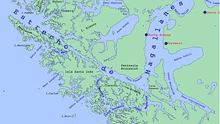
The Strait of Magellan, also called the Straits of Magellan, is a navigable sea route in southern Chile separating mainland South America to the north and the Tierra del Fuego archipelago to the south. The strait is considered the most important natural passage between the Atlantic and Pacific oceans. The strait is approximately 570 km long and 2 km wide at its narrowest point. In 1520, the Spanish expedition of the Portuguese navigator Ferdinand Magellan, after whom the strait is named, became the first Europeans to discover it.

Isla Grande de Tierra del Fuego also formerly Isla de Xátiva is an island near the southern tip of South America from which it is separated by the Strait of Magellan. The western portion (61.4%) of the island is in Chile, while the eastern portion is in Argentina. It forms the major landmass in an extended group of islands or archipelago also known as Tierra del Fuego.

Father Alberto Maria de Agostini born in Pollone, Piedmont was an Italian missionary of the Salesians of Don Bosco order as well as a passionate mountaineer, explorer, geographer, ethnographer, photographer and cinematographer.

Eric Earle Shipton, CBE, was an English Himalayan mountaineer.

Mount Darwin is a peak in Isla Grande de Tierra del Fuego forming part of the Cordillera Darwin, the southernmost range of the Andes, just to the north of the Beagle Channel. It is 2,438 m high.

The Kangshung Face or East Face is the eastern-facing side of Mount Everest, one of the Tibetan sides of the mountain. It is 3,350 metres (11,000 ft) from its base on the Kangshung Glacier to the summit. It is a broad face, topped on the right by the upper Northeast Ridge, and on the left by the Southeast Ridge and the South Col. Most of the upper part of the face is composed of hanging glaciers, while the lower part consists of steep rock buttresses with couloirs between them. The steep southern third of the Kangshung Face also comprises the Northeastern Face of Lhotse; this section may be considered a separate face altogether following the division of the South "Neverest" Buttress up to the South Col. It is considered a dangerous route of ascent, compared to the standard North Col and South Col routes, and it is the most remote face of the mountain, with a longer approach.

Alberto de Agostini National Park is a protected area that was created on January 22, 1965, on land that was formerly part of the "Hollanda" forest reserve and "Hernando de Magallanes National Park". It covers 1,460,000 hectares and includes the Cordillera Darwin mountain range, which is the final land-based stretch of the Andes before it becomes a chain of mountains appearing as small islands that sink into the Pacific Ocean and the Beagle Channel.

The Cordillera Darwin is an extensive mountain range mantled by an ice field that is located in Chile.

Monte San Lorenzo, also known as Monte Cochrane, is a mountain on the border between Argentina and Chile in Patagonia, reaching a height of 3,706 metres (12,159 ft). The Chilean name of Cochrane comes from the nearby town of Cochrane where climbers often approach the mountain. The peak was first climbed by Alberto María de Agostini in 1943.

Mount Tarn is a small mountain located on the southernmost part of the Strait of Magellan, in Brunswick Peninsula, about 70 km south of Punta Arenas, Chile. It is in the southern extreme of continental Chile very close to Cape Froward, surrounded by historic places such as Fort Bulnes and Puerto del Hambre.

De Agostini Fjord, also known as De Agostini Sound, is a fjord in Tierra del Fuego that separates two branches of the Cordillera Darwin, the Cordón Navarro in the southwest and the mountain range that includes Monte Buckland in the northeast. It is named after the Italian explorer Alberto María de Agostini. The latter range contains some of the most rugged peaks in southern Chile and the former is a mostly ice-covered range. It connected to Magdalena Channel via Keats Sound.
Magdalena Channel is a Chilean channel joining the Strait of Magellan with the Cockburn Channel and is part of a major navigation route which ultimately connects with the Beagle Channel. It separates Capitán Aracena Island from the westernmost portion of Isla Grande de Tierra del Fuego, and crosses Alberto de Agostini National Park. It is flanked by mountains, the chief of which is Monte Sarmiento. Like the Abra Channel and the Bárbara Channel farther west, it joins the western part of the Strait of Magellan directly to the Pacific Ocean.

Carlo Mauri was an Italian mountaineer and explorer. Mauri was born in Lecco. Among his early climbs in the Alps two stand out: the first winter ascent of the via Comici route on the northern face of Cima Grande di Lavaredo; and the first solitary ascent of the Poire of Mont Blanc. Numerous expeditions abroad followed. In 1956 he reached the summit of Monte Sarmiento in Tierra del Fuego and in 1958, as a member of Riccardo Cassin’s expedition in Karakorum, he and Walter Bonatti made the first ascent of Gasherbrum IV.
John Roskelley is an American mountain climber and author. He made first ascents and notable ascents of 7,000-meter and 8,000-meter peaks in Nepal, India, and Pakistan. In 2014, he became the 6th winner of the Piolet d'Or Lifetime Achievement Award.

Monte Buckland is a prominent peak in Alberto de Agostini National Park, in the Chilean portion of Tierra del Fuego. It towers over a narrow peninsula between Agostini Fjord and Fitton bay, which is an eastward projection of the Gabriel Channel, which separates Dawson Island from Isla Grande de Tierra del Fuego. The mounts Sella, Aosta and Giordano are located to the southeast of Mt Buckland and have distinctive shapes.

Yendegaia National Park is in Tierra del Fuego in the Magallanes y la Antártica Chilena Region of Chile and contains 150,612 ha of mountainous terrain and Valdivian temperate rain forest. It borders the Alberto de Agostini National Park and Tierra del Fuego National Park.

Monte Burney is a volcano in southern Chile, part of its Austral Volcanic Zone which consists of six volcanoes with activity during the Quaternary. This volcanism is linked to the subduction of the Antarctic Plate beneath the South America Plate and the Scotia Plate.
Alessandra Boarelli was an Italian mountaineer and, in 1864, became the first woman to summit Monviso in the Alps.

