
Mont Blanc is the highest mountain in the Alps and Western Europe, and the highest mountain in Europe outside the Caucasus Mountains, rising 4,805.59 m (15,766 ft) above sea level, located on the Franco-Italian border. It is the second-most prominent mountain in Europe, after Mount Elbrus, and the 11th most prominent mountain in the world.

The Matterhorn is a mountain of the Alps, straddling the main watershed and border between Italy and Switzerland. It is a large, near-symmetric pyramidal peak in the extended Monte Rosa area of the Pennine Alps, whose summit is 4,478 metres (14,692 ft) above sea level, making it one of the highest summits in the Alps and Europe. The four steep faces, rising above the surrounding glaciers, face the four compass points and are split by the Hörnli, Furggen, Leone/Lion, and Zmutt ridges. The mountain overlooks the Swiss town of Zermatt, in the canton of Valais, to the northeast; and the Italian town of Breuil-Cervinia in the Aosta Valley to the south. Just east of the Matterhorn is Theodul Pass, the main passage between the two valleys on its north and south sides, which has been a trade route since the Roman Era.

The Dufourspitze is the highest peak of Monte Rosa, an ice-covered mountain massif in the Alps. Dufourspitze is the highest mountain of both Switzerland and the Pennine Alps and is also the second-highest mountain of the Alps and Western Europe, after Mont Blanc. It is located between Switzerland and Italy. The peak itself is located wholly in Switzerland.

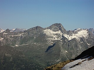
Monte Rosa is a mountain massif in the eastern part of the Pennine Alps, on the border between Italy and Switzerland (Valais). The highest peak of the massif, amongst several peaks of over 4,000 m (13,000 ft), is the Dufourspitze, the second highest mountain in the Alps and western Europe, after Mont Blanc. The east face of the Monte Rosa towards Italy has a height of about 2,400 metres (7,900 ft) and is the highest mountain wall of the Alps.

Brusson is a town and comune in the Ayas Valley, a left side valley of the Aosta Valley region in Italy.

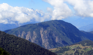
Monte Grappa is a mountain of the Venetian Prealps in Veneto, Italy. It lies between the Venetian plain to the south and the central alpine areas to the north. To the west, it is parted from the Asiago upland by the Brenta river, and to the east it is separated from the Cesen-Visentin massif by the Piave river. To the north lie Corlo lake and Feltre valley. In the past, the mountain was called Alpe Madre, and is currently divided among three provinces: Vicenza to the west, Treviso to the south and Belluno to the northeast. It is the highest peak of a small massif, which also includes many other peaks such as Col Moschin, Colle della Berretta, Monte Asolone, Monte Pertica, Prassolan, Monti Solaroli, Fontana Secca, Monte Peurna, Monte Santo, Monte Tomatico, Meatte, Monte Pallon, and Monte Tomba.

Monte Generoso is a mountain of the Lugano Prealps, located on the border between Switzerland and Italy and between Lake Lugano and Lake Como. The western and southern flanks of the mountain lie in the Swiss canton of Ticino, whilst the north-eastern flanks are in the Italian region of Lombardy.

Santa Caterina di Valfurva is a frazione of the comune of Valfurva, in the northern Italian province of Sondrio. It is home to a popular ski resort, which has held numerous FIS World Cup alpine races; Santa Caterina co-hosted the World Championships with Bormio in 1985 and 2005. The highest point of the resort is on the Monte Sobretta.

Monte Resegone or Resegone di Lecco, also known as Monte Serrada, is a mountain of the Bergamasque Prealps in Lombardy, northern Italy. It has an elevation of 1,875 m and is located on the border between the provinces of Bergamo and Lecco.

Champoluc is a village in the commune of Ayas, in the province of Aosta Valley, Northern Italy.
Monte Antola is a mountain in Liguria, northern Italy, part of the Ligurian Apennines.
Monte Buio is a mountain in Liguria, northern Italy, part of the Ligurian Apennines. It is located between the provinces of Genoa and Alessandria. It lies at an altitude of 1400 metres.

The Vincent Pyramid is a mountain of the Pennine Alps, located on the border between the Italian regions of Aosta Valley and Piedmont. The Vincent Pyramid makes up a large buttress of the huge multi-summited Monte Rosa. It lies south of the Ludwigshöhe on the border with Switzerland, between the Lysgletscher and the Piode Glacier. A secondary summit of the Vincent Pyramid, the Punta Giordani/Giordanispétz, lies to the southeast. Both Vincent Pyramid and Punta Giordani are on the official UIAA list of Alpine four-thousanders.

Mont Néry is a mountain of the Pennine Alps in Aosta Valley, northwestern Italy.
Grand Tournalin (3,379m) is a mountain of the Monte Rosa Massif in the Pennine Alps in Aosta Valley, Italy. It is the highest mountain between the Ayas Valley and Valtournenche. The mountain is composed of two summits, the north being higher than the south summit by just 9m.

Testa Grigia (3,315m) is a mountain on the Italian side of the Monte Rosa Massif in the Pennine Alps. It is the highest mountain of the ridge that separates the Lys valley (Gressoney-La-Trinité) from the Ayas Valley, in Aosta Valley.

Corno Bussola is a 3,023 metres high peak on the Italian side of the Pennine Alps.
The Testa di Comagna is a 2,106 metres high peak on the Italian side of the Pennine Alps.

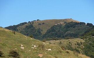
The Monte San Giorgio is a mountain in the Cottian Alps, Metropolitan City of Turin in Piedmont, north-western Italy. It is located in the comune of Piossasco.

Mount Tantané is a 2734 metre high mountain of the Pennine Alps in Aosta Valley, Italy. It lies between the Ayas Valley to the east and the Valtournenche Valley to the west.


