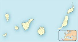
The Canary Islands, also known informally as the Canaries, are a Spanish region, autonomous community and archipelago in the Atlantic Ocean. At their closest point to the African mainland, they are 100 kilometres west of Morocco. They are the southernmost of the autonomous communities of Spain. The islands have a population of 2.2 million people and are the most populous special territory of the European Union.
Las Palmas, officially Las Palmas de Gran Canaria, is a Spanish city and capital of Gran Canaria, in the Canary Islands, in the Atlantic Ocean.

Gran Canaria, also Grand Canary Island, is the third-largest and second-most-populous island of the Canary Islands, an archipelago off the Atlantic coast of Northwest Africa and is part of Spain. As of 2023 the island had a population of 862,893 that constitutes approximately 40% of the population of the archipelago. Las Palmas de Gran Canaria, the capital of the island, is the biggest city of the Canary Islands and the ninth of Spain.

La Palma, also known as La isla bonita and historically San Miguel de La Palma, is the most northwesterly island of the Canary Islands, Spain, which is a Spanish autonomous community and archipelago in Macaronesia in the North Atlantic Ocean. La Palma has an area of 708.32 square kilometres (273.48 sq mi) making it the fifth largest of the eight main Canary Islands. The total population at the start of 2023 was 84,338, of which 15,522 lived in the capital, Santa Cruz de La Palma and 20,375 in Los Llanos de Aridane. Its highest mountain is the Roque de los Muchachos, at 2,426 metres (7,959 ft), being second among the peaks of the Canaries after the Teide massif on Tenerife.

Santa María de Guía de Gran Canaria is a town and a municipality in Las Palmas province of the Canary Islands. It is located on the north side of Gran Canaria island. Its population is 13,811 (2013), and the area is 42.59 km2 (16.44 sq mi).

Firgas is a town and a municipality in the northern part of the island of Gran Canaria, in the Province of Las Palmas, in the Canary Islands. Its population is 7,628 (2013), and its area is 15.77 km². Firgas was founded in 1488, and it is situated in the mountains, 13 km west of Las Palmas. The town, which is located in a green and rural zone, is also known as the balcony of the Atlantic, as it provides good views of the northern coast of the island. Bottled water is produced in the town.

Santa Brígida is a municipality in the northeastern part of the island of Gran Canaria in the Province of Las Palmas of the Canary Islands. Its population is 18,791 (2013), and the area is 23.81 km2. It borders Las Palmas to the west and is part of its urban area.

San Bartolomé de Tirajana is a village and a Spanish municipality in the south-eastern part of the island of Gran Canaria in the Las Palmas province in the Canary Islands. With an area of 333.13 km2 (128.62 sq mi), San Bartolomé de Tirajana is the largest municipality in area on the island as well as the Canary Islands. The population is 56,698 (2013).

Tejeda is a village and a municipality in the mountainous central part of the island of Gran Canaria in the province of Las Palmas in the Canary Islands.
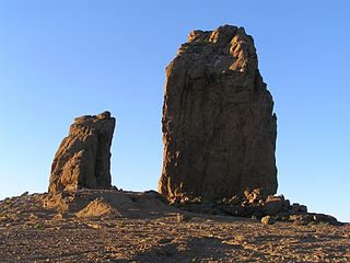
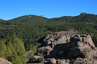
Roque Nublo is a volcanic rock on the island of Gran Canaria, Canary Islands, Spain. It is 80 m (262 ft) tall, and its top is 1,813 m (5,948 ft) above sea level. The Roque Nublo is the third highest point on the island of Gran Canaria, after the Morro de la Agujereada at 1,956 m (6,417 ft), and the Pico de las Nieves at 1,949 m (6,394 ft).
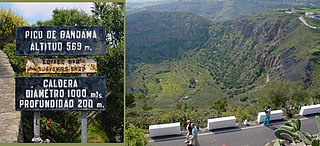
The Bandama Natural Monument is part of the Tafira Protected Landscape on the island of Gran Canaria in the Canary Islands, Spain. It is considered a point of geological interest, because of the Caldera de Bandama. This volcanic crater, which is geologically a maar rather than a caldera, reaches 569 m (1,867 ft) above sea level at the highest point on its rim, Pico de Bandama, and is about 1,000 m (3,300 ft) wide and 200 m (700 ft) deep. The crater was developed during the last heavy eruptions 2000 years ago. It is recorded as the most recent volcanic activity on Gran Canaria.
Trasmediterránea operates passengers and cargo ferries between mainland Spain and the Canary Islands, the Balearic Islands, and northern Africa's Spanish territories. Since 2017 the majority of the company belongs to Naviera Armas.

Tourism is an essential part of the economy of the Canary Islands, a Spanish archipelago located in the Atlantic Ocean, 100 kilometres west of Morocco. Seven main islands and six islets make up the Canary Islands. They had 16 million visitors in 2023. Tourists seeking sunshine and beaches first began to visit the Canaries in large numbers in the 1960s. The Canary Islands are a leading European tourist destination with very attractive natural and cultural resources.
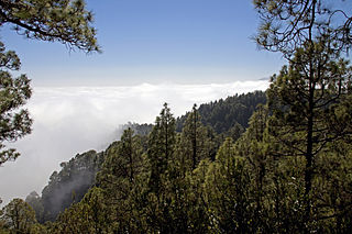
Pico de las Nieves is the highest peak and a stratovolcano on the island of Gran Canaria, Canary Islands, Spain. Its height is 1,949 metres (6,394 ft) above sea level. On its slopes, Canary Islands Pine was reintroduced in the 1950s.

Punta La Entallada or La Entallada Lighthouse is an active lighthouse on the Canary island of Fuerteventura. It is located on the east coast, near the village of Las Playitas in Tuineje.

The Maspalomas Lighthouse is an active 19th century lighthouse at the southern end of the Spanish island of Gran Canaria, in the Canary archipelago. It lies at one end of the Maspalomas beach, 4 kilometres (2.5 mi) south of the resort town centre, next to the area known as the Maspalomas Dunes.

The Punta de Melenara Lighthouse also known as the Faro de Taliarte is an active 20th century lighthouse on the Spanish island of Gran Canaria in the Canary Islands.
The Canary Islands dry woodlands and forests is a Mediterranean forests, woodlands, and scrub ecoregion in the Canary Islands. It encompasses the western group of the Canary Islands – La Palma, El Hierro, La Gomera, Tenerife, and Gran Canaria – in the Atlantic Ocean. These volcanic islands are an autonomous community of Spain, and lie southwest of the Spanish mainland and west of the North African coast.

The GC-3, known officially as Circunvalación de Las Palmas de Gran Canaria is a superhighway in Gran Canaria. It connects the two trunk roads GC-1 and GC-2 over a length of 13 km (8.1 mi). A good half of the north-south traffic on the island is now handled by the GC-3, which significantly relieves the Avenida Marítima and the Túnel del Ingeniero Julio Luengo.

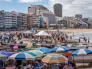
The Playa de Las Canteras is the main urban beach of the city of Las Palmas de Gran Canaria, one of the most important beaches of the Canary Islands.