
Conisbrough is a town within the City of Doncaster, in South Yorkshire, England. It is roughly midway between Doncaster and Rotherham, and is built alongside the River Don at 53°29′N1°14′W. It has a ward population of 14,333.

The Pennines, also known as the Pennine Chain or Pennine Hills, are a range of uplands mainly located in Northern England. Commonly described as the "backbone of England" because of its length and position, the range runs from Derbyshire and Staffordshire in the north of the Midlands to Northumberland in North East England. From the Tyne Gap in the north, the range extends south through the North Pennines, Yorkshire Dales, South Pennines, and Peak District to end near the valley of the River Trent. The Border Moors and Cheviot Hills, which lie beyond the Tyne Gap, are included in some definitions of the range.

The Metropolitan Borough of Rotherham is a metropolitan borough of South Yorkshire, England. It is named after its main settlement of Rotherham. The wider borough spans a larger area and covers the outlying towns of Maltby, Swinton, Wath-upon-Dearne, Dinnington. As well as the villages of Rawmarsh and Laughton. A large valley spans the entire borough and is referred to as the "Rother Valley".

Woodsetts is a village and civil parish in the Metropolitan Borough of Rotherham in South Yorkshire, England, on the border with Nottinghamshire. It lies between the towns of Dinnington and Worksop at an elevation of around 60 metres above sea level, and has a population of 1,746 at the 2011 Census. The village originated as a medieval farming hamlet of the manor of Anston, nestled amongst the ancient woodland of which a few patches remain. The village grew rapidly in the late 19th century when a colliery was sunk at Dinnington. The village now serves as a commuter base for travellers between nearby towns.

Thorpe Salvin is a village and a civil parish in the Metropolitan Borough of Rotherham in South Yorkshire, England, on the border with Nottinghamshire. It lies between Worksop and Harthill, and is located at an elevation of around 110 metres above sea level. At the 2011 Census, it had a population of 476, down from 502 in 2001.
Whiston is a village and civil parish in the Metropolitan Borough of Rotherham in South Yorkshire, England. It has a population of 5,115, reducing to 5,042 at the 2011 Census.
Thorp is a Middle English word for a hamlet or small village.

Strafforth and Tickhill, originally known as Strafforth, was the southernmost wapentake in the West Riding of Yorkshire, England. The west of the district, plus a detached area in the east, constituted the Upper Division, while the central area and a detached part in the extreme east constituted the Lower Division.
Laughton en le Morthen is a village and civil parish in the Metropolitan Borough of Rotherham lying to the south of Rotherham, South Yorkshire, England, and its main attraction is the All Saints Church with its tower and spire of 185 feet. The village had a population of 1,241 at the 2011 Census. The parish also includes the hamlets of Carr, Slade Hooton and Brookhouse.
Roger de Busli was a Norman baron who participated in the conquest of England in 1066.

The A631 is a road running from Sheffield, South Yorkshire to Louth, Lincolnshire in England. It passes through the counties of South Yorkshire, Nottinghamshire and Lincolnshire. The road has many towns on its route including Rotherham, Maltby, Gainsborough and Market Rasen. It is mostly single road throughout its length but has some stretches of dual carriageway as well.

St John's Church is a redundant Anglican church near the village of Throapham, on the road between Dinnington and Laughton-en-le-Morthen, South Yorkshire, England. It is recorded in the National Heritage List for England as a designated Grade I listed building, and is under the care of the Churches Conservation Trust.

Chapel-en-le-Frith is a town and civil parish in the Borough of High Peak in Derbyshire, England.

Carr is a hamlet in the civil parish of Laughton-en-le-Morthen, in the Rotherham district lying to the south of Rotherham, South Yorkshire, England.

Brampton-en-le-Morthen is a small dormitory village and former civil parish, now in the parish of Thurcroft, in the Rotherham district lying to the south of Rotherham, South Yorkshire, England. In 1911, the parish had a population of 148.
Laughton en le Morthen is a civil parish in the Metropolitan Borough of Rotherham, South Yorkshire, England. The parish contains 27 listed buildings that are recorded in the National Heritage List for England. Of these, one is listed at Grade I, the highest of the three grades, two are at Grade II*, the middle grade, and the others are at Grade II, the lowest grade. The parish contains the village of Laughton en le Morthen, the smaller settlements of Brookhouse, Carr, and Slade Hooton, and the surrounding countryside. Most of the listed buildings are houses, cottages and associated structures, farmhouses and farm buildings. The other listed buildings include a church and its vicarage, a school, a cascade, and a telephone kiosk.
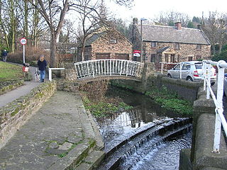
Whiston is a civil parish in the Metropolitan Borough of Rotherham, South Yorkshire, England. The parish contains 18 listed buildings that are recorded in the National Heritage List for England. Of these, three are listed at Grade II*, the middle of the three grades, and the others are at Grade II, the lowest grade. The parish contains the villages of Whiston and Morthen and the surrounding countryside. Most of the listed buildings are houses and associated structures, farmhouses and farm buildings. The other listed buildings include a church, a headstone in the churchyard, a cross base, a set of stocks, and two mileposts.
Slade Hooton is a hamlet in the Metropolitan Borough of Rotherham, in South Yorkshire, England. Historically in the West Riding of Yorkshire, the hamlet was moved into South Yorkshire in April 1974.


