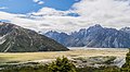
Aoraki / Mount Cook is the highest mountain in New Zealand. Its height, as of 2014, is listed as 3,724 metres. It is situated in the Southern Alps, the mountain range that runs the length of the South Island. A popular tourist destination, it is also a favourite challenge for mountain climbers. Aoraki / Mount Cook consists of three summits: from south to north, the Low Peak, the Middle Peak and the High Peak. The summits lie slightly south and east of the main divide of the Southern Alps, with the Tasman Glacier to the east and the Hooker Glacier to the southwest. Mount Cook is ranked 10th in the world by topographic isolation.

The Thumbs is a 2,546-metre-elevation (8,353-foot) mountain in the Canterbury Region of New Zealand.

Mount D'Archiac is a 2,875-metre-elevation (9,432-foot) mountain in the Canterbury Region of New Zealand.

Mount Pembroke is a 2,015-metre-elevation (6,611-foot) mountain in Fiordland, New Zealand.

Mount Chudleigh is a 2,966-metre-elevation (9,731-foot) mountain in New Zealand.

Mount Wolseley is a 2,558-metre-elevation (8,392-foot) mountain in the Canterbury Region of New Zealand.

Mount Loughnan is a 2,590-metre-elevation (8,497-foot) mountain in New Zealand.

Mount Forbes is a 2,583-metre-elevation (8,474-foot) mountain in the Canterbury Region of New Zealand.

Mount Moffat is a 2,638-metre-elevation (8,655-foot) mountain in the Canterbury Region of New Zealand.

The Footstool is a 2,764-metre-elevation (9,068-foot) mountain in the Canterbury Region of New Zealand.

Dilemma Peak is a 2,602-metre-elevation (8,537-foot) mountain in the West Coast Region of New Zealand.

The Nuns Veil is a 2,749-metre-elevation (9,019-foot) mountain in the Canterbury Region of New Zealand.

Mount Darwin is a 2,952-metre-elevation (9,685-foot) mountain in the Canterbury Region of New Zealand.

Hochstetter Dome is a 2,827-metre-elevation (9,275-foot) mountain in New Zealand.

Mount Edgar Thomson is a 2,379-metre-elevation (7,805-foot) mountain in the Canterbury Region of New Zealand.

Aiguilles Rouges is a 2,950-metre-elevation (9,678-foot) mountain in the Canterbury Region of New Zealand.

Mount Huxley is a 2,505-metre-elevation (8,219-foot) mountain in New Zealand.

Mount Green is a 2,837-metre-elevation (9,308-foot) mountain in New Zealand.

Mount Thomson is a 2,642-metre-elevation (8,668-foot) mountain in New Zealand.

Mount Avalanche is a 2,606-metre-elevation (8,550-foot) mountain in New Zealand.