| The Nuns Veil | |
|---|---|
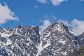
 West aspect | |
| Highest point | |
| Elevation | 2,749 m (9,019 ft) [1] [2] |
| Prominence | 558 m (1,831 ft) [3] |
| Isolation | 11.3 km (7.0 mi) [2] |
| Listing | New Zealand #21 |
| Coordinates | 43°41′36″S170°14′50″E / 43.69333°S 170.24722°E [2] |
| Geography | |
 The Nuns Veil Location in New Zealand | |
 | |
| Interactive map of The Nuns Veil | |
| Location | South Island |
| Country | New Zealand |
| Region | Canterbury |
| Protected area | Aoraki / Mount Cook National Park |
| Parent range | Southern Alps Liebig Range [4] |
| Topo map(s) | NZMS260 I36 [5] Topo50 BX16 [4] |
| Climbing | |
| First ascent | 4 December 1907 |
The Nuns Veil is a 2,749-metre-elevation (9,019-foot) mountain in the Canterbury Region of New Zealand.