
Officially Good Hope Mountain but commonly known as Mount Good Hope is one of the principal summits of the Pacific Ranges of the southern Coast Mountains in British Columbia, Canada. It stands immediately west of Chilko Lake, with the highest peak on the massif rising between the lake's southern arms.

Monmouth Mountain, commonly known as Mount Monmouth is one of the principal summits of the Pacific Ranges of the Coast Mountains of southern British Columbia. At 3,182 m (10,440 ft), it is the highest summit of the Chilcotin Ranges. It stands just north of the Lillooet Icecap between the heads of Chilko Lake and the Taseko Lakes. West of Chilko Lake's south arm is Mount Good Hope 3,242 m (10,636 ft) and, beyond it, the massif surrounding Mount Queen Bess 3,298 m (10,820 ft), which is the highest summit east of the Homathko River.

Jervis Inlet is one of the principal inlets of the British Columbia Coast, about 95 km (59 mi) northwest of Vancouver, and the third of such inlets north of the 49th parallel, the first of which is Burrard Inlet, Vancouver's harbour.
Kingcome Inlet is one of the lesser principal fjords of the British Columbia Coast, north and east of Broughton Island. It is sixth in sequence of the major saltwater fjords north from the 49th parallel near Vancouver and similar in width, on average 2.5 km (1.6 mi), to longer inlets such as Knight Inlet and Bute Inlet, but it is only 35 km (22 mi) in length from the mouth of the Kingcome River to Sutlej Channel, which ultimately connects around Broughton Island to the main regional waterway of the Queen Charlotte Strait. Kingcome Inlet has a short side inlet, Wakeman Sound, fed by the Wakeman River.
Burgoyne Bay Provincial Park is a provincial park in British Columbia, Canada located on southwestern Saltspring Island near Fulford Harbour. The parks faces northwest to Sansum Narrows, which is the channel between Saltspring Island and Vancouver Island. Mount Maxwell Provincial Park lies adjacent to the north.
Háthayim Marine Provincial Park, formerly Von Donop Marine Provincial Park, is a provincial park in British Columbia, Canada, located on the north end of Cortes Island in the Discovery Islands.

Sir James Clark Ross was a British Royal Navy officer and explorer of both the northern and southern polar regions. In the Arctic, he participated in two expeditions led by his uncle, John Ross, and in four led by William Edward Parry: in the Antarctic, he led his his own expedition from 1839 to 1843.
Quatsino Sound is a complex of coastal inlets, bays and islands on northwestern Vancouver Island in the Canadian province of British Columbia. It is the northernmost of the five sounds that pierce the west coast of Vancouver Island, the others being Kyuquot Sound, Nootka Sound, Clayoquot Sound, and Barkley Sound.
Actaeon or Acteon (Ἀκτέων) was a hero in Greek mythology.

HMS Actaeon was a 26-gun sixth-rate frigate of the Royal Navy.

Mount Frederick William is a mountain located at the Queen Reach arm of the Jervis Inlet within the Pacific Ranges of the Coast Mountains in British Columbia Canada. The mountain was named during the 1860 survey by HMS Plumper which charted all of the area and named the mountain after then-Prussian Crown Prince Frederick William, who had married Princess Victoria, the eldest child of Queen Victoria and Prince Albert.

Mount Arthur is a mountain located at the Queen Reach arm of the Jervis Inlet within the Pacific Ranges of the Coast Mountains in British Columbia Canada. The mountain was named during the 1860 survey by HMS Plumper who charted all of the area and named the mountain after Prince Arthur William Patrick who was the seventh son of Queen Victoria and Prince Albert of England.
Mount Helena is a mountain located at the Queen Reach arm of Jervis Inlet and behind Princess Louisa Inlet. Mount Helena is part of the Pacific Ranges of the Coast Mountains in British Columbia Canada. The mountain was named during the 1860 survey by HMS Plumper who charted all of the known area and named the mountain after Princess Helena Augusta Victoria "Lenchen" who was the fifth child of Queen Victoria and Prince Albert of England.
ḵ’els is a mountain located at the head of lekw’emin above the ancestral shíshálh village site of x̱enichen and within the Pacific Ranges of the Coast Mountains of British Columbia, Canada. The mountain is associated with a shíshálh legend about a great flood.

The Britannia Range is a small mountain range of the Coast Mountains that runs along the eastern shore of Howe Sound just north of Vancouver, British Columbia, Canada. It is a subrange of the Pacific Ranges and often considered part of the North Shore Mountains. The range is bounded by the Howe Sound to the west, the Stawamus River to the north, Loch Lomond on the upper Seymour River to the east, and Deeks Lake to the south. However, some official maps extend the range further south of these boundaries and many local sources such as hiking guidebooks will often include all of the peaks along the Howe Sound between Deeks Lake and Cypress Mountain as part of the range.
Actaeon Sound is a sound in the Queen Charlotte Strait region of the Central Coast of British Columbia, branching off northeasterly from the north side of Drury Inlet near its head on the mainland of British Columbia to the north of the town of Port McNeill, on the opposite side of Queen Charlotte Strait. On the south side of the sound is the Bond Peninsula at 50°56′50″N127°06′55″W, which is formed by a sidewater, Bond Lagoon at 50°56′34″N127°06′34″W, both presumably named in 1865 by Captain Pender, in association with other Admiralty and HMS Actaeon-related names.
The Gwawaenuk Tribe, or Gwawaʼenux̱w is a First Nations band government of the Kwakwaka'wakw people located in the Queen Charlotte Strait region of the Central Coast region of British Columbia, Canada. The Gwawaenuk Tribe has no year-round road access to a service centre and being about 160 km to 240 km from the nearest service centre.
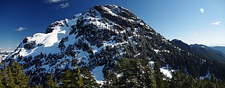
Mount Brunswick, 1,788 metres (5,866 ft), is a summit in the Britannia Range of the North Shore Mountains on the Howe Sound side of the latter range. The mountain is located just northwest of the village of Lions Bay and is the namesake of Brunswick Beach, a locality on the Howe Sound shoreline below. Brunswick is often considered the highest peak of the North Shore Mountains.

Mount Harvey, 1,652 m (5,420 ft), is a mountain in the Britannia Range of the North Shore Mountains just northeast of the Village of Lions Bay, British Columbia, Canada.
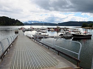
Drury inlet is an inlet in the Queen Charlotte Strait region of the Central Coast of British Columbia, Canada, extending west from Wells Passage to the northwest of North Broughton Island, northwest of the town of Port Hardy. Branching off to the northeast from the north side of the head of the inlet is Actaeon Sound.

