Mount Cheminis

Last updated
Mount Cheminis
Mont Chaudron or Sugar-Loaf Mountain
Mount Chaudron - panoramio.jpg
2009 photo
Highest point
Coordinates 48°08′22″N79°30′37″W / 48.1394440°N 79.5102780°W / 48.1394440; -79.5102780
Geography
Canada Quebec relief location map.jpg
Red triangle with thick white border.svg
Mount Cheminis
Location within Quebec
Topo map NTS 32D4 Larder Lake

Mount Cheminis (also known as Mont Chaudron, and Sugar-Loaf Mountain) is an inselberg/monadnock located in Quebec, Canada, near the Ontario border.

Contents

It is one of the highest peaks in the Abitibi-Témiscamingue region, a tourist attraction and a place that has spiritual significance for Indigenous peoples.

Nomenclature

Mount Cheminis is also known as Mont Chaudron, and Sugar-Loaf Mountain. [1]

According to Gloria MacKenzie and Marcia Brown of Beaverhouse First Nation band office, the name is derived from the Chamminis, which translates into English as the "place of healing or healers. [2] "

Geology and location

1997 photo of Mount Cheminis Mont Chaudron 1.jpg
1997 photo of Mount Cheminis

Mount Cheminis is an isolated hill of hard resistant caprock that rises abruptly from the surrounding relatively flat land which has been eroded away. [1] It was created in the most recent ice age. It is situated at the point of V-sharped lines of geological ridges, which are understood to have diverted the retreating ice sheet east and west. [1] The features were formed as part of the same glaciological movements that create the Collines kékéko (English: Kékéko Hills), although the physical appearance between the two features is notably different. [3]

It is one of the highest peaks in the Abitibi-Témiscamingue region. [3]

Mount Cheminis is located in Quebec between Lake Temiskaming and Lake Abitibi close to the border of Ontario. [1] It is close to Kearns, Ontario (also known as McGarry), Kap-Kig-Iwan Provincial Park, and also the Timiskaming District near Ontario Highway 66 [1] [4] and Quebec Route 117. [3]

It was described in 2019 as "one of the most striking landscape features in all of Northern Ontario". [5]

Significance to Indigenous peoples

Mount Cheminis is used by Indigenous peoples of Canada for ceremony. [5] [4] Dr. Jonathan Pitt of Nipissing University's Schulich School of Education Aboriginal Education Programs said in 2021 that "Rock formations like Mount Cheminis are important to Indigenous spirituality." [1]

Significance in tourism

View from Mount Cheminis, 2008 Mont chaudron 2.jpg
View from Mount Cheminis, 2008

Mount Cheminis provides panoramic views that attract tourists, although a 1984 report from Collège de l'Abitibi-Témiscamingue noted rotting stairs and a lack of maintenance on and around the hill. [3]

In human history

Canadian geologist Robert Bell wrote about Mount Cheminis after he surveyed Lake Temiskaming in 1887. [1]

From 1925 to 1927, Mount Cheminis marked the end of the Temiskaming & Northern Ontario Railway due to the refusal of the Quebec government to allow expansion into their territory. [2]

From 1926 until 1946 it was the location of a post office. [2]

A mutilated human body was found at the top of Mount Cheminis in 1955. [1] [6]

In 2019, 17-year-old hiker Brennan Goulding, died as he fell while climbing Mount Cheminis. [1] [7]

Related Research Articles

<span class="mw-page-title-main">Lake Abitibi</span> Lake on Ontario / Quebec border, Canada

Lake Abitibi is a shallow lake in northeastern Ontario and western Quebec, Canada. The lake, which lies within the vast Clay Belt, is separated in two distinct portions by a short narrows, making it actually two lakes. Its total area is 931 square kilometres (359 sq mi), and net area 903 square kilometres (349 sq mi). The lake is shallow and studded with islands. Its shores and vicinity are covered with small timber.

<span class="mw-page-title-main">Rouyn-Noranda</span> City in Quebec, Canada

Rouyn-Noranda is a city on Osisko Lake in the Abitibi-Témiscamingue region of Quebec, Canada.

<span class="mw-page-title-main">Timiskaming District</span> District in Ontario, Canada

Timiskaming is a district and census division in Northeastern Ontario in the Canadian province of Ontario. The district was created in 1912 from parts of Algoma, Nipissing, and Sudbury districts. In 1921, Cochrane District was created from parts of this district and parts of Thunder Bay District.

<span class="mw-page-title-main">Temiskaming Shores</span> City in Ontario, Canada

Temiskaming Shores is a city in the Timiskaming District in Northeastern Ontario, Canada. It was created by the amalgamation of the town of New Liskeard, the town of Haileybury, and the township of Dymond in 2004. The city had a total population of 9,634 in the Canada 2021 Census. Temiskaming Shores is Ontario's second-smallest city, in terms of population, after Dryden. Haileybury is the seat of Timiskaming District.

<span class="mw-page-title-main">Abitibi—Témiscamingue (electoral district)</span> Federal electoral district in Quebec, Canada

Abitibi—Témiscamingue is a federal electoral district in Quebec, Canada, that has been represented in the House of Commons of Canada since 2004. The area was also represented by the electoral district of Témiscamingue from 1968 until 2004.

<span class="mw-page-title-main">Abitibi-Témiscamingue</span> Administrative region in Quebec, Canada

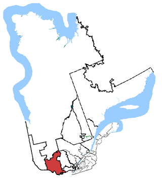
Abitibi-Témiscamingue is an administrative region located in western Québec, Canada, along the border with Ontario. It became part of the province in 1898. It has a land area of 57,736.50 square kilometres (22,292.19 sq mi) and its population was 147,082 people as of the 2021 census. The region is divided into five regional county municipalities and 79 municipalities. Its economy continues to be dominated by resource extraction industries. These include logging and mining all along the rich geologic Cadillac Fault between Val-d'Or and Rouyn-Noranda, as well as agriculture.

<span class="mw-page-title-main">Pontiac (federal electoral district)</span> Federal electoral district in Quebec, Canada

Pontiac is a federal electoral district in western Quebec, Canada, that has been represented in the House of Commons of Canada from 1867 to 1949 and since 1968.

<span class="mw-page-title-main">Témiscaming</span> City in Quebec, Canada

Témiscaming is a city located at the south end of Lac Témiscamingue on the upper Ottawa River in the Témiscamingue Regional County Municipality of western Quebec, Canada. Also nearby is Lake Kipawa.

Timiskaming is a word from the Algonquin Temikami or Temikaming, from tim 'deep' and kami 'open waters'. Alternate spellings include Temiskaming, Témiscaming and Témiscamingue. The word Temagami comes from the same root.

Alexis Wawanoloath is a lawyer in Indigenous peoples' law and was Canadian politician. He was a member of National Assembly of Quebec for the riding of Abitibi-Est, representing the Parti Québécois. He is a member of the Abenaki First Nation.

<span class="mw-page-title-main">Fort Témiscamingue</span>

Fort Témiscamingue was a trading post from the 18th century in Duhamel-Ouest, Quebec, near Ville-Marie, Canada, located on the fur trade route on the east shore of Lake Timiskaming. The fort is a National Historic Site, operated as part of the national park system by Parks Canada, in partnership with the Timiskaming First Nation.

<span class="mw-page-title-main">Aiguebelle National Park</span>

Aiguebelle National Park(French: Parc national d'Aiguebelle) is a provincial park in Quebec, Canada. It is located in western Quebec in the Abitibi-Témiscamingue region some 50 km north-east of Rouyn-Noranda, 50 km west of Amos, Quebec, 100 km north west of Val-d'Or, Quebec, and about 50 km due west of Lake Hebecourt. The park has a surface area of 268,3 km2.

<span class="mw-page-title-main">Christine Moore (politician)</span> Canadian politician

Christine Moore is a Canadian politician and nurse who served as the Member of Parliament (MP) for the riding of Abitibi—Témiscamingue from 2011 to 2019. A member of the New Democratic Party (NDP), she was first elected in the 2011 Canadian federal election, defeating Bloc Québécois MP Marc Lemay, who had held the riding since 2004. She was re-elected during the 2015 federal election. She did not run for re-election in the 2019 federal election. Despite her Anglophone-sounding name, Moore is a Francophone.

<span class="mw-page-title-main">Lake Blouin</span>

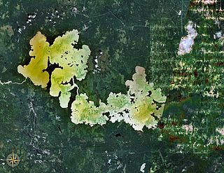
Lake Blouin is an ellipse shaped natural fresh water lake in the Abitibi-Témiscamingue Administrative Region, Quebec, Canada. The lake, oriented on a southwest–northeast axis, measures 13.5 km (8 mi) in length and has a maximum width of 2 km (1 mi). It is relatively shallow with a maximum depth of 30 m (98 ft), and is located just north of the city of Val-d’Or, Quebec. It is fed by the Bourlamaque and Senneville rivers and is the headwater of the Harricana River. All three rivers are situated near its northeastern end. The shore of lake Blouin is lined with small rocky outcrops and sandy beaches. The lake lies within the Clay Belt, a vast tract of fairly flat land with fertile soil covering 180,000 km2 (69,000 sq mi) in northwest Quebec and northeast Ontario.

The ZEC Restigo is a "zone d'exploitation contrôlée" (ZEC) located the unorganized territory Les Lacs-du-Témiscamingue, in the Témiscamingue Regional County Municipality, in the administrative region of Abitibi-Témiscamingue, Quebec, Canada.

<span class="mw-page-title-main">St. Teresa of Avila Cathedral (Amos)</span> Church in Quebec, Canada

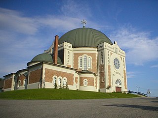
The Cathedral of St. Teresa of Avila is the cathedral of the Roman Catholic Diocese of Amos, which encompasses western and northern Quebec, Canada. It is located in the center of Amos, on the east bank of the Harricana River on the highest hill of the town, and visible for a great distance. It is the only Catholic cathedral in the Abitibi-Témiscamingue region.

<span class="mw-page-title-main">Ignace Tonené</span> Algonquin chief (1840/41–1916)

Ignace Tonené, also known as Nias or by his Ojibwe name Maiagizis, was a Teme-Augama Anishnabai chief, fur trader, and gold prospector in Upper Canada. He was a prominent employee of the Hudson's Bay Company.

<span class="mw-page-title-main">Mount Kanasuta</span> Hilled area of Quebec

Mount Kanasuta, often known as Mont Kanasuta, is a hilled area near the Quebec–Ontario border in the Abitibi-Témiscamingue administrative region of Quebec, Canada.

References

  1. 1 2 3 4 5 6 7 8 9 Steer, Bill (17 Feb 2021). "Explore a towering monadnock with Back Roads Bill". ElliotLakeToday.com. Retrieved 2022-04-26.
  2. 1 2 3 Buell, Richard (April 2006). "Once upon a Cheminis". HighGrader . Archived from the original on 1 January 2006. Retrieved 1 May 2022.
  3. 1 2 3 4 Audet, Sonia, Blais Normand, Lavoie Michelle, L'Heureux Stéphane, Morin Rémi, and Prévost Louise, Sites Géologiques Touristiques en Abitibi-Témiscamingue, September 1984, l'Abitibi-Témiscamingue College, Department of History and Geography (in French), p. 32.
  4. 1 2 Dénommé-Welch, Spy; Becker, Jean; Garcia Vega, Cecilia (2 March 2022). "Moving Toward Land-Based Sound Archiving and Composition: Reflecting on Field Research From the Project Sonic Coordinates: Decolonizing Through Land-Based Composition". Collections: A Journal for Museum and Archives Professionals. 18 (1): 72–83. doi: 10.1177/15501906211072917 . ISSN   1550-1906.
  5. 1 2 Steer, Bill (9 March 2019). "Lonely Mount Cheminis a spiritual rock". North Bay Nugget . Archived from the original on 2021-01-23. Retrieved 2022-04-26.
  6. "Police to Bring Skeleton to City for Examination". The Gazette. Montreal. 12 Jul 1955. p. 3. Retrieved 1 May 2022.
  7. "'Everybody loved him': parents remember Brennan Goulding". CBC. 25 July 2019.