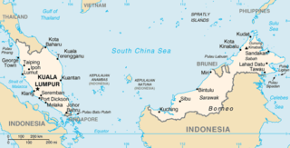
The geography of Malaysia includes both the physical and the human geography of Malaysia, a Southeast Asian country made up of two major landmasses separated by water—Peninsular Malaysia to the west and East Malaysia to the east—and numerous smaller islands that surround those landmasses. Peninsular Malaysia is on the southernmost part of the Malay Peninsula, south of Thailand, north of Singapore and east of the Indonesian island of Sumatra; East Malaysia comprises most of the northern part of Borneo, and shares land borders with Brunei to the north and Indonesian Borneo to the south.

Mount Tahan, is the highest point in Peninsular Malaysia with an elevation of 7,175 ft (2,187 m) above sea level, on the border between the states of Pahang and Kelantan, with the peak lying on the Pahangese side. It is part of the Taman Negara that straddles Jerantut District in Pahang, Gua Musang District in Kelantan and Hulu Terengganu District in Terengganu. The mountain is part of the Tahan Range in the Tenasserim Hills and is popular with local climbers.

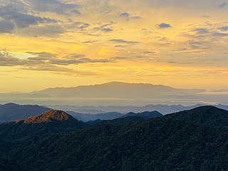
Taman Negara is a national park in Peninsular Malaysia. It was established in 1938 and 1939 as the King George V National Park after Theodore Hubback lobbied the sultans of Pahang, Terengganu and Kelantan to set aside a piece of land that covers the three states for the creation of a protected area. After independence, it was renamed Taman Negara, which means "national park" in Malay.
The Titiwangsa Mountains, also known as Banjaran Besar by locals, is the chain of mountains that forms the backbone of the Malay Peninsula. The northern section of the range is in southern Thailand, where it is known as the Sankalakhiri Range.

The Bintang Mountains is a mountain range, part of the Tenasserim Hills, that encompasses the states of Kedah and Perak, Malaysia. It runs from the province of Yala, southern Thailand in the north, straddling along the Kedah–Perak border and ends in the south near Beruas, Manjung District, western Perak. Within Perak, the mountain range forms a natural boundary between the districts of Kuala Kangsar and Hulu Perak in the east and Larut, Matang and Selama in the west. It borders the Titiwangsa Mountains, Peninsular Malaysia's chief mountain range, to its east. The range divides the basins of Kerian and Perak Rivers in the west and east respectively.

Mount Batu Brinchang, or Mount Brinchang, is a mountain in the Titiwangsa Range, situated on the border between the Malaysian states of Pahang and Perak. At 2,032 metres above sea level, it is the second highest mountain in the Cameron Highlands region, as well as the highest mountain in the area that can be accessed by car. It is one of the mountains in Malaysia where its summit can be reached by road. Due to easy accessibility, this mountain enjoys many visitors all year round.

Mount Korbu is a mountain in Hulu Kinta, Perak, Malaysia, about 25 km from Ipoh. It is the highest peak in the state of Perak, located on the Titiwangsa Mountains, the southernmost section of the Tenasserim Hills.

Mount Pueh, also known as Mount Pueh-Berumput, Mount Poi and Mount Poe, is a mountain located near Lundu, Sarawak on the Malaysia-Indonesia border. Mount Pueh was known to biologists for the collections made there by Eric Mjöberg (1882–1938), a Swedish naturalist, who was Curator of the Sarawak Museum between 1922 and 1924. Mjöberg's herpetological collections from Gunung Pueh between October and December 1923, and other localities in Borneo, were reported by Smith (1925). Mjöberg, unfortunately, left little by way of written records, of his ascent of Pueh and the collections he made.

Mount Ledang is a mountain located in Tangkak District, Johor, Malaysia. The summit is located next to the tripoint of Tangkak, Jasin and Tampin districts, located in the states of Johor, Malacca and Negeri Sembilan, respectively. Standing at 1,276 m (4,186 ft), it is the 64th highest mountain in Malaysia and the highest peak in Johor.
The Titiwangsa Forest Complex runs along the Titiwangsa Mountains and forms part of the Central Forest Spine of Peninsular Malaysia.
The Tenasserim Hills or Tenasserim Range is the geographical name of a roughly 1,700 km long mountain chain, part of the Indo-Malayan mountain system in Southeast Asia.
Mount Bintang is a mountain on the border of the states of Kedah and Perak in the Bintang Mountains, Malaysia, specifically on the quadripoint between the districts of Kulim, Baling, Larut, Matang and Selama and Hulu Perak. Its summit is 1,862 m (6,109 ft) above sea level. It is the highest mountain in the state of Kedah.

Mount Yong Yap is a mountain located along the Perak and Kelantan state border in Peninsular Malaysia. At 2,168 m (7,113 ft), it is the third highest mountain in Kelantan and the sixth highest in Peninsular Malaysia. This mountain is part of the Titiwangsa Range which is an extension of the Tenasserim Range from Myanmar and Thailand.

Mount Yong Belar is a mountain on the border of the states Kelantan and Perak in the Titiwangsa Mountains of Malaysia. Its summit is 2,181 m (7,156 ft) above sea level, making it the highest mountain in the state of Kelantan, and the third highest in Peninsular Malaysia, behind Mounts Tahan and Korbu, the latter being located 8 km north.
Mount Benum or Mount Benom is a mountain in the state of Pahang in Malaysia. Its summit is 2,107 m (6,913 ft) above sea level. The mountain is located in a centre of an isolated massif east of the Titiwangsa Mountains.
Mount Alab is a mountain located at the border of the West Coast as well as the Interior divisions of Sabah, Malaysia. The mountain is located approximately 30 km (19 mi) from Sabah's capital of Kota Kinabalu, where it can be highly visible from the city on a clear sky and easily recognisable with the presence of telecommunications tower near its peak, approximately at 5°49′47″N116°20′30″E. With a height of 1,951 metres (6,401 ft), it is the highest mountain within the Crocker Range in Sabah outside the protected park area and lies to the south of the highest peak on Borneo island, the Mount Kinabalu.
Flower's blind lizard is a legless lizard endemic to peninsular Malaysia. It is between 8–13 cm (3.1–5.1 in) long and is gray-brown in color with a lighter ventral surface and a silver-gray band. It burrows beneath rocks, leaf-litter and rotting logs.

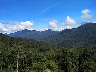
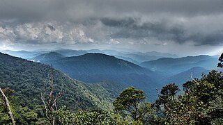
The Peninsular Malaysian montane rain forests is an ecoregion on the Malay Peninsula. It occupies the mountainous spine of the peninsula in Malaysia and southernmost Thailand. It is in the tropical and subtropical moist broadleaf forests biome.
Mount Lawit is a mountain in Terengganu, Malaysia and has an elevation of 1,519 metres, which makes it the highest mountain in the state. Mount Lawit is situated northeast of Gunong Batil, and northwest of Sungai Susu Dara. Both locations are located in Besut District.
Mount Besar Hantu is a mountain in Kenaboi, Jelebu District, Negeri Sembilan, Malaysia, located near the border with Pahang. It is the tallest peak in Negeri Sembilan as well in southern Peninsular Malaysia, at the height of 1,462 m (4,797 ft).
