
Banten is the westernmost province on the island of Java, Indonesia. Its capital city is Serang and its largest city is Tangerang. The province borders West Java and the Special Capital Region of Jakarta on the east, the Java Sea on the north, the Indian Ocean on the south, and the Sunda Strait on the west and shares a maritime border with Lampung to the west. The province covers an area of 9,352.77 km2 (3,611.12 sq mi). It had a population of over 11.9 million in the 2020 census, up from about 10.6 million in 2010. The estimated mid-2023 population was 12.308 million. Formerly part of the province of West Java, Banten was split off to become a province on 17 October 2000.

The Indonesian island of Java is almost entirely of volcanic origin, and contains numerous volcanoes, 45 of which are considered active volcanoes. As is the case for many other Indonesian islands, volcanoes have played a vital role in the geological and human history of Java. Indeed, land is created on Java as a result of lava flows, ash deposits, and mud flows (lahars). Volcanoes are a major contributor to the immense fertility of Java, as natural erosion transports volcanic material as alluvium to the island's plains, forming thick layers of fertile sediment. The benefit is not just in the immediate vicinity of the volcano, with fine ash emitted from eruptions being dispersed over wide areas.

Mount Kerinci, also spelled Kerintji, is an active stratovolcano and the highest mountain in Sumatra, Indonesia. At 12,484 ft (3,805 m) above sea level, it provides Sumatra with the fifth-highest maximum elevation of any island in the world. It is surrounded by the lush forest of Kerinci Seblat National Park, home to several endangered species including the Sumatran tiger. Mount Kerinci is ranked 32nd by topographic isolation.

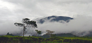
Gunung Karang is a volcano at the center of Banten, Indonesia. It is also the highest point of the province.

Mount Pulosari is a stratovolcano in Pandeglang Regency, Banten, in West Java Indonesia. There are active solfataras on its 300-metre (980 ft) deep caldera wall.

Mount Merbabu is a dormant stratovolcano in Central Java province on the Indonesian island of Java. The name Merbabu could be loosely translated as 'Mountain of Ash' from the Javanese combined words; Meru means "mountain" and awu or abu means "ash".

Bogor Regency is a landlocked regency (kabupaten) of West Java province in Indonesia, situated south of DKI Jakarta. Covering an area of 2,734.33 km2, it is considered a bedroom community for Jakarta, and was home to 5,427,068 people at the 2020 census. The official estimate as at mid 2023 was 5,520,836. The town of Cibinong serves as the regency seat.
Perbakti is an eroded stratovolcano west of Mount Salak in West Java, Indonesia. The summit is elongated in a northwest-southwest direction, in which Gunung Endut volcano rises above the saddle of Perbakti. Two 2 km wide depressions on the northern and the southern side has formed two rivers, the Kaluwung Herang and Pamatutan rivers. Fumaroles, mud pots and hot springs are located on the south and the southeast flanks.

Mount Salak is an eroded volcano in West Java, Indonesia. It has several satellite cones on its southeast flank and the northern foot, along with two additional craters at the summit. Mount Salak has been evaluated for geothermal power development. According to a popular belief, the name "Salak" is derived from salak, a tropical fruit with scaly skin; however, according to Sundanese tradition, the name was derived from the Sanskrit word Salaka which means "silver". Mount Salak can be translated to "Silver Mountain" or "Mount Silver".
Mount Gede Pangrango National Park is a national park in West Java, Indonesia. The park is centred on two volcanoes—Mount Gede and Mount Pangrango—and is 150 km² in area.

Ichthyophis hypocyaneus, the Javan caecilian or marsh caecilian, is a species of amphibian in the family Ichthyophiidae of caecilians, endemic to Java, Indonesia. Until its rediscovery in 2000, it was known only from the 1827 type specimen.

The Javan ferret-badger is a mustelid endemic to Java and Bali, Indonesia. It is listed as Least Concern on the IUCN Red List and occurs from at least 260 to 2,230 m elevation in or close to forested areas.

The Kasepuhan Banten Kidul are a traditional Sundanese community of approximately 5,300 people, who live in the southern part of Gunung Halimun National Park, in the Indonesian province of West Java. Mount Halimun Salak National Park is located within the borders of the Sukabumi Regency, Bogor and southern Banten province. The Kasepuhan is called "Kasepuhan Banten Kidul", and their main village is Ciptagelar in the Cisolok subdistrict (kecamatan) in the western part of the Sukabumi Regency. The current head of the community, Abah Ugih, inherited the position of leader when his father, Abah Anom, died at the age of 54.

Mount Halimun Salak National Park is a 400 km2 conservation area in the Indonesian province of West Java on the island of Java. Established in 1992, the park comprises two mountains, Mount Salak and Mount Halimun with an 11-kilometer forest corridor. It is located near the better known Mount Gede Pangrango National Park, but the national park should be accessed from Sukabumi, 2 hours drive to the administration post and then 2 hours drive again to Cikaniki post gate.
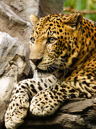
The Javan leopard is a leopard subspecies confined to the Indonesian island of Java. It has been listed as Endangered on the IUCN Red List since 2021. The population is estimated at 188–571 mature individuals in 22 fragmented subpopulations and a declining population trend. The total remaining habitat is estimated at only 2,267.9 to 3,277.3 km2.

The Ci Durian, or Ci Kandi, is a river in the Banten province of western Java, Indonesia. It rises in the mountains to the south and flows north to the Java Sea. The delta of the river, now canalized, has long been used for rice paddies and a period was also used for sugarcane plantations. Extensive irrigation works diverted water from the river into a canal system in the 1920s, but these works were not completed and suffered from neglect in the post-colonial era. Plans were made in the 1990s to rehabilitate the irrigation works and dam the river to provide water for industrial projects, with Dutch and Japanese assistance, but these were cancelled by the Indonesian government.

Kawah Putih is a crater lake and tourist spot in a volcanic crater about 50 kilometres (31 mi) south of Bandung, West Java, Indonesia.
Deconica aureicystidiata is a species of mushroom in the family Strophariaceae. It has been found in Mount Halimun Salak National Park and Gunung Gede Pangrango National Park in Java, Indonesia.

The Cianten is a river that flows in the western part of Bogor Regency, West Java and is a tributary of the Cisadane River.

