
Agathis australis, or kauri, is a coniferous tree in the family Araucariaceae, found north of 38°S in the northern regions of New Zealand's North Island.
Whangārei is the northernmost city in New Zealand and the regional capital of Northland Region. It is part of the Whangarei District, a local body created in 1989 from the former Whangārei City, Whangārei County and Hikurangi Town councils, to administer both the city proper and its hinterland. The city population was estimated to be 56,900 in June 2023, an increase from 47,000 in 2001.

The Northland Region is the northernmost of New Zealand's 16 local government regions. New Zealanders sometimes refer to it as the Winterless North because of its mild climate all throughout the year. The main population centre is the city of Whangārei, and the largest town is Kerikeri. At the 2018 New Zealand census, Northland recorded a population growth spurt of 18.1% since the previous 2013 census, placing it as the fastest growing region in New Zealand, ahead of other strong growth regions such as the Bay of Plenty Region and Waikato.

Dargaville is a town located in the North Island of New Zealand. It is situated on the bank of the Northern Wairoa River in the Kaipara District of the Northland region. Dargaville is located 55 kilometres (34 mi) southwest of Whangārei, and 174 kilometres (108 mi) north of Auckland.
The Waitākere Ranges is a mountain range in New Zealand. Located in West Auckland between metropolitan Auckland and the Tasman Sea, the ranges and its foothills and coasts comprise some 27,720 hectares of public and private land. The area, traditionally known to Māori as Te Wao Nui o Tiriwa, is of local, regional, and national significance. The Waitākere Ranges includes a chain of hills in the Auckland Region, generally running approximately 25 kilometres (16 mi) from north to south, 25 km west of central Auckland. The ranges are part of the Waitākere Ranges Regional Park.

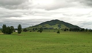
Mount Pirongia is an extinct stratovolcano located in the Waikato region of New Zealand's North Island. It rises to 959 m (3,146 ft) and is the highest peak around the Waikato plains. Pirongia's many peaks are basaltic cones created by successive volcanic eruptions between the late Pliocene and early Pleistocene, about 2.5 million years ago. In the adjacent picture, the characteristic profile of the mountain can be seen, along with a prominent accessory cone to the right.

Mount Cargill, known in Māori as Kapukataumahaka, is a volcanic outcrop which dominates the skyline of northern Dunedin, New Zealand.
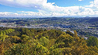
Hurupaki Mountain is in Kamo, Whangārei, New Zealand. The centre of Hurupaki Mountain lies between Three Mile Bush Road and Dip Road, approximately 1.5 kilometres west of Kamo township. Hurupaki Mountain is visible from State Highway 1.
Aranga is a locality in Northland, New Zealand. State Highway 12 passes through it. Ōmāpere is 47 km northwest, and Dargaville is 42 km southeast. The Waipoua Forest is to the north. Maunganui Bluff and the Tasman Sea are to the west, with the small settlement of Aranga Beach lying at the northern end of Ripiro Beach.

Hikurangi is a settlement in Northland, New Zealand. The city of Whangārei is 17 kilometres (11 mi) to the south, and Kawakawa is 39 kilometres (24 mi) northwest. The Glenbervie Forest is southeast of the settlement. State Highway 1 once passed through the town, but now bypasses it to the west. Mount Hikurangi is a volcanic dome rising 365 metres (1,198 ft) to the west of the town. It is 1.2 million years old, and part of the Harbour Fault which also includes Parakiore, near Kamo, and Parihaka in Whangarei.
Kauri is a locality in Northland, New Zealand. State Highway 1 passes through the area. Kamo is to the south, and Hikurangi is to the north. Mt Parakiore is a volcanic dome rising 391 metres (1,283 ft) to the southwest. It is about one million years old, and part of the Harbour Fault, which also includes Mt Hikurangi near Hikurangi, and Parahaki in Whangarei.
The Punakitere River is a river of the Northland Region of New Zealand's North Island. It is a tributary of the Taheke River, which forms the Waimā River, though it is longer than the Waimā itself. The Punakitere is polluted, especially with e-coli and phosphorus, and has its origins in several streams which flow through and to the south of Kaikohe, as well as from Mount Hikurangi. The rivers flow predominantly westward to reach the Waimā close to the small settlement of Moehau.
The Tākou River is a river of the Northland Region of New Zealand's North Island. It flows generally east from its sources east of Kaeo to reach the Pacific Ocean at Tākou Bay, 14 km (8.7 mi) north of Kerikeri.

New Zealand's Northland Region is built upon a basement consisting mainly of greywacke rocks, which are exposed on the eastern side of the peninsula. In-place Eocene coal measures crop out at Kamo, near Whangārei, and Oligocene limestone crops out at Hikurangi, near Whangārei.
Kakepuku is a volcanic cone which rises from the plain between the Waipā and Puniu rivers, about 3 km (2 mi) NW of Te Kawa and 8 km (5 mi) SW of Te Awamutu in the Waikato region of New Zealand's North Island.

Hapuakohe Range of hills is aligned north–south, between the Waikato River and the Hauraki Plains in the Waikato region of New Zealand. It is separated from the Taupiri Range by an air-gap at Mangawara, where the Waikato flowed about 20,000 years ago.

Waipoua Settlement is a rural community in the Kaipara District of Northland, in New Zealand's North Island.
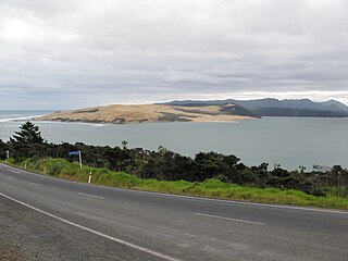
Ōmāpere is a settlement on the south shore of Hokianga Harbour in Northland, New Zealand. State Highway 12 runs through Ōmāpere. Opononi is on the shore to the north of Ōmāpere.

Lake Rotokawau is a small volcanic lake 4.1 km (2.5 mi) east of Lake Rotorua in the Bay of Plenty region of New Zealand's North Island. The name is also used for lakes in the Kaipara District, Chatham Islands, on Aupouri Peninsula and near Lake Waikare in Waikato. Access is via Lake Rotokawau Road, from SH30 at Tikitere. The lake is owned and managed by Ngāti Rangiteaorere.
The Whangārei volcanic field is an area of intra-plate monogenetic volcanism located near the city of Whangārei, North Island, New Zealand. It was last active between 260,000 to 319,000 years ago and continues to be potentially active as a low-velocity seismic zone in the crust exists beneath Whangārei, which is interpreted to be a body of partial melt. This mantle source has been coupled to the lithosphere for about 8 million years. As the field has potentially been active at low frequency for millions of years, with 100,000 years or more between events it might best be regarded as dormant. The recent vents active in the last million years include some dacite in composition. Composition details are freely available for most of the field but many vents do not have ages.
