
The Special Region of Yogyakarta is a province-level special region of Indonesia in southern Java. It is a semi-enclave that is surrounded by on the landward side by Central Java Province to the west, north, and east, but has a long coastline on the Indian Ocean to the south.

The Ring of Fire is a tectonic belt of volcanoes and earthquakes.

The Bromo, or Mount Bromo is an active somma volcano, a Hindu pilgrimage site, and part of the Tengger mountains, in East Java, Indonesia. At 2,329 meters (7,641 ft) it is not the highest peak of the massif, but is the most active and famous. The area is one of the most visited tourist destinations in East Java, and the volcano is included in the Bromo Tengger Semeru National Park. The name Bromo comes from the Javanese pronunciation of Brahma, the Hindu god of creation. At the mouth of the crater, there is an idol of Ganesha, the Hindu god of wisdom which is being worshipped by the Javanese Hindus. Mount Bromo is located in the middle of a plain called "Sea of Sand", a nature reserve that has been protected since 1919.

Mount Merapi is an active stratovolcano located on the border between the province of Central Java and the Special Region of Yogyakarta, Indonesia. It is the most active volcano in Indonesia and has erupted regularly since 1548. It is located approximately 28 km (17 mi) north of Yogyakarta city which has a population of 2.4 million. Thousands of people live on the flanks of the volcano, with villages as high as 1,700 m (5,577 ft) above sea level.

Mount Rinjani is an active volcano in Indonesia on the island of Lombok. Administratively the mountain is in the Regency of North Lombok, West Nusa Tenggara. It rises to 3,726 metres (12,224 ft), making it the second highest volcano in Indonesia. It is also the highest point in the Indonesian province of West Nusa Tenggara. Adjacent to the volcano is a 6-by-8.5-kilometre caldera, which is filled partially by the crater lake known as Segara Anak or Anak Laut, due to the color of its water, as blue as the sea (laut). This lake is approximately 2,000 metres (6,600 ft) above sea level and estimated to be about 200 metres (660 ft) deep; the caldera also contains hot springs. The lake and mountain are sacred to the Sasak people and Hindus, and are the site of religious rituals. UNESCO made Mount Rinjani Caldera a part of the Global Geoparks Network in April 2018.
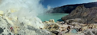
The Ijen volcano complex is a group of composite volcanoes located on the border between Banyuwangi Regency and Bondowoso Regency of East Java, Indonesia. It is known for its blue fire, acidic crater lake, and labour-intensive sulfur mining.
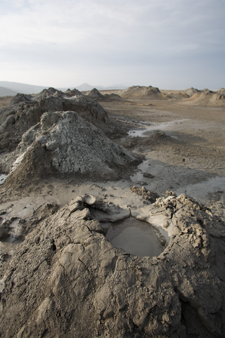
A mud volcano or mud dome is a landform created by the eruption of mud or slurries, water and gases. Several geological processes may cause the formation of mud volcanoes. Mud volcanoes are not true igneous volcanoes as they do not produce lava and are not necessarily driven by magmatic activity. Mud volcanoes may range in size from merely 1 or 2 meters high and 1 or 2 meters wide, to 700 meters high and 10 kilometers wide. Smaller mud exudations are sometimes referred to as mud-pots.

The Kelud is a mountain stratovolcano located in Kediri, East Java, Indonesia. Like many Indonesian volcanoes and others on the Pacific Ring of Fire, Kelud is known for large explosive eruptions throughout its history. More than 30 eruptions have occurred since 1000 AD. In 2007, an effusive explosion filled the crater with a lava dome. It last erupted on 13 February 2014, destroying the lava dome and ejecting boulders, stones and ashes up to West Java about 500 kilometres (310 mi) from Mount Kelud. The crater filled with water during the rainy season.

Bukittinggi is the third largest city in West Sumatra, Indonesia, with a population of 111,312 in 2010 and 121,028 in 2020, and an official estimate as at mid 2023 of 124,047 - comprising 61,949 males and 62,098 females. It covers an area of 25.24 km2. It is located in the Minangkabau Highlands, 90 km by road from the West Sumatran capital city of Padang. The city is completely surrounded by the Agam Regency, making it an enclave within the regency, and it is located at 0°18′20″S100°22′9″E, near the volcanoes Mount Singgalang (inactive) and Mount Marapi. At 930 m above sea level, the city has a cool climate with temperatures between 16.1° to 24.9 °C.

The Semeru, or Mount Semeru is an active volcano located in East Java, Indonesia. It is located in a subduction zone, where the Indo-Australian plate subducts under the Eurasia plate. It is the highest mountain on the island of Java. The name "Semeru" is derived from Meru, the central world mountain in Hinduism, or Sumeru, the abode of gods. This stratovolcano is Mahameru, meaning "The Great Mountain" in Sanskrit. It is one of the more popular hiking destinations in Indonesia.
Lake Diatas is a lake in West Sumatra, Indonesia. It is located at 1°4′37″S100°45′17″E. This lake together with Lake Dibawah, are known as the Twin Lakes.

Lake Dibawah is a lake in West Sumatra, Indonesia. It is located at 1°0′35″S100°43′51″E. This lake together with Lake Diatas, are known as the Twin Lakes.

Mount Merbabu is a dormant stratovolcano in Central Java province on the Indonesian island of Java. The name Merbabu could be loosely translated as 'Mountain of Ash' from the Javanese combined words; Meru means "mountain" and awu or abu means "ash".

Mount Sinabung is a Pleistocene-to-Holocene stratovolcano of andesite and dacite in the Karo plateau of Karo Regency, North Sumatra, Indonesia, 40 kilometres (25 mi) from the Lake Toba supervolcano. Many old lava flows are on its flanks and the last known eruption, before recent times, occurred 1200 years before present, between 740 - 880 CE. Solfataric activities were last observed at the summit in 1912; recent documented events include an eruption in the early hours of 29 August 2010 and eruptions in September and November 2013, January, February and October 2014. The volcano has recently claimed the life of at least 23 people in a number of events since 2014. Between 2013 and 2014, the alert for a major event was increased with no significant activity. On 2 June 2015, the alert was again increased, and on 26 June 2015, at least 10,000 people were evacuated, fearing a major eruption. The long eruption of Mount Sinabung is similar to that of Mount Unzen in Japan, which erupted for five years after lying dormant for 400 years. A major eruption began on 10 August 2020.

Mount Arjuno-Welirang is a stratovolcano in the province of East Java in Java, Indonesia. Mount Arjuno-Welirang lies about 50 kilometers south of Surabaya, and 20 kilometers north of Malang. It is a twin volcano, with the 'twins' being Arjuno and Welirang. There is at least one other stratovolcano in the area, and around 10 pyroclastic cones nearby. They are located in a 6 km line between Arjuno and Welirang. The Arjuno-Welirang volcanic complex itself lies in the older two volcanoes, Mount Ringgit to the east and Mount Linting to the south. The summit lacks vegetation. Fumarolic areas with sulfur deposits are found in several locations in Welirang.
Kembar is an Indonesian and Malay word meaning twin.
Gunung is the Malay and Indonesian word for mountain —it is regularly used in volcano and mountain names throughout Southeast Asia.

Yuki Anggraini Kato, better known as Yuki Kato, is an Indonesian actress, model, and television presenter of mixed Javanese and Japanese descent.

A drawing of twin mountains is a drawing pattern commonly made by Indonesian kindergarten and primary school students. The drawing is often produced by students who are asked by their teacher to draw natural features.
