K2, at 8,611 metres (28,251 ft) above sea level, is the second highest mountain in the world, after Mount Everest at 8,848 metres (29,029 ft). It is located on the China–Pakistan border between Baltistan in the Gilgit-Baltistan region of northern Pakistan, and Dafdar Township in Taxkorgan Tajik Autonomous County of Xinjiang, China. K2 is the highest point of the Karakoram range and the highest point in both Pakistan and Xinjiang.

Longs Peak is a high and prominent mountain summit in the northern Front Range of the Rocky Mountains of North America. The 14,259-foot (4346 m) fourteener is located in the Rocky Mountain National Park Wilderness, 9.6 miles (15.5 km) southwest by south of the Town of Estes Park, Colorado, United States. Longs Peak is the northmost "fourteener" in the Rocky Mountains and the highest point in Boulder County and Rocky Mountain National Park. The mountain was named in honor of explorer Stephen Harriman Long and is featured on the Colorado state quarter.

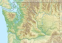
The North Cascades are a section of the Cascade Range of western North America. They span the border between the Canadian province of British Columbia and the U.S. state of Washington and are officially named in the U.S. and Canada as the Cascade Mountains. The portion in Canada is known to Americans as the Canadian Cascades, a designation that also includes the mountains above the east bank of the Fraser Canyon as far north as the town of Lytton, at the confluence of the Thompson and Fraser Rivers.

The Uinta Mountains are an east-west trending chain of mountains in northeastern Utah extending slightly into southern Wyoming in the United States. As a subrange of the Rocky Mountains, they are unusual for being the highest range in the contiguous United States running east to west, and lie approximately 100 miles (160 km) east of Salt Lake City. The range has peaks ranging from 11,000–13,528 feet (3,353–4,123 m), with the highest point being Kings Peak, also the highest point in Utah. The Mirror Lake Highway crosses the western half of the Uintas on its way to Wyoming.

Mount Rundle is a mountain in Canada's Banff National Park overlooking the towns of Banff and Canmore, Alberta. The Cree name was Waskahigan Watchi or house mountain. In 1858 John Palliser renamed the mountain after Reverend Robert Rundle, a Methodist invited by the Hudson's Bay Company to do missionary work in western Canada in the 1840s. He introduced syllabics there—a written language developed for the Cree, as part of his missionary work. He only visited the Stoney-Nakoda of the area around what is now called Mount Rundle in 1844 and 1847.

Mount Stuart is a mountain in the Cascade Range, in the U.S. state of Washington. It is the second highest non-volcanic peak in the state, after Bonanza Peak and tenth-highest overall. Mount Stuart is the highest peak in the Stuart Range, and it is located in the central part of the Washington Cascades, south of Stevens Pass and east of Snoqualmie Pass in the Alpine Lakes Wilderness.

Jack Mountain is the 17th highest mountain in Washington state. It is one of the 10 non-volcanic peaks in Washington State over 9,000 feet (2,700 m). It towers dramatically over the south end of Ross Lake, rising 7,450 ft above the lakeshore in only 3 horizontal miles (4.8 km). Nohokomeen Glacier nearly fills the cirque on the upper north slopes of the mountain.
The Entiat River is a tributary of the Columbia River, joining the Columbia near Entiat. The United States Geological Survey (USGS) lists two variant names for the Entiat River: En-ti-at-kwa River and Entiatqua River. The river's name is derived from the Columbia-Moses (Salishan) term /nt'yátkw/ [nt'iátkw], meaning "place of grassy water"; another source states that it was called Enteatqua which means "Rapid Water" or "Rushing Water." The name, spelled "Entiat", was selected for the river in 1958 by the Chelan County Public Utility District.

Silver Star Mountain is an 8,876-foot (2,705-metre) mountain located in Okanogan County, Washington. The mountain is part of the Methow Mountains, a subset of the Cascade Range. Silver Star is the dominant feature in the Washington Pass area and visible from the North Cascades Highway. It was first climbed by Lage Wernstedt in 1926.

Mount Triumph is a summit in the North Cascades range of Washington state. Located approximately 5.5 miles (8.9 km) west-northwest of the town of Newhalem, it was named by Lage Wernstedt, a surveyor with the U.S. Forest Service. A significant peak in North Cascades National Park, Mount Triumph is one of its "outstanding sights" and is well known among regional climbers for its lack of easy climbing routes to the summit. Despite its moderate elevation, its local relief is dramatic. With the terrain deeply dissected by the valleys of Bacon Creek on the west and Goodell Creek on the east, it rises 1 mile (1.6 km) in less than 2 miles (3.2 km) on the latter side.

Eldorado Peak is a 8,868-foot (2,703 m) peak, and is the 25th highest peak in Washington. The mountain is located in the North Cascades of Washington, approximately 27 miles (43 km) east of Concrete. It is located in North Cascades National Park at the head of Marble Creek and just west of the Inspiration Glacier. Other glaciers in the immediate vicinity include Eldorado Glacier and McAllister Glacier; thus Eldorado is flanked by the largest continuous non-volcanic ice sheet in the lower 48 states.

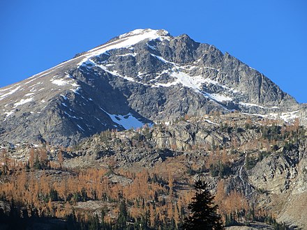
Mount Fernow is a tall peak in the North Cascades in the U.S. state of Washington and within the Glacier Peak Wilderness of the Wenatchee National Forest. At 9,249 feet (2,819 m) in elevation it is the eighth-highest peak in Washington and the state's third-highest non-volcanic peak. It is also the highest peak of the Entiat Mountains, a sub-range of the Cascades. Mount Fernow's prominence is 2,811 ft (857 m), making it the sixtieth-most-prominent peak in Washington. The closest peak to Fernow is Copper Peak, 0.88 mi (1.42 km) to the north, and the nearest higher peak is Bonanza Peak, 5.9 mi (9.5 km) to the north.

Buckner Mountain is a tall peak in the North Cascades of Washington state and in the Stephen Mather Wilderness of North Cascades National Park. At 9,114 feet (2,778 m) in elevation it is the highest in Skagit County and one of about ten of Washington's non-volcanic peaks above 9,000 feet high. It is ranked as the 14th highest peak in the state, and the third highest peak in North Cascades National Park.

Seven Fingered Jack is a mountain in the North Cascades in the U.S. state of Washington. It is located at the north end of the Entiat Mountains, a sub-range of the Cascade Range. It is part of a three-peak group called the Entiat Cirque which includes Mount Maude and Mount Fernow. Seven Fingered Jack is about 4 miles (6.4 km) south of Holden. The peak is in the Glacier Peak Wilderness of Wenatchee National Forest.

The Entiat Mountains, or Entiat Range is a mountain range in the U.S. state of Washington. Located west of the Columbia River, north of the Wenatchee River, and south of the Entiat River, the range is part of the North Cascades section of the Cascade Range. The Entiat Range is relatively narrow east to west and long north to south. The Entiat River valley separates the Entiat Mountains from the Chelan Mountains to the northeast. To the west and south, across the Wenatchee River and tributaries such as the Chiwawa River are the Wenatchee Mountains.

Mount Spickard is a 8,980-foot (2,740 m) mountain peak in the North Cascades, a mountain range in the U.S. state of Washington. Located just 2 miles (3.2 km) south of the Canada–US border, it is part of the Chilliwack Group, a subrange of the Skagit Range which is part of the North Cascades. It is composed mainly of gneiss and is part of two major drainage basins: that of the Skagit River and Fraser River.

Albert Hale Sylvester was a pioneer surveyor, explorer, and forest supervisor in the Cascade Range of the U.S. state of Washington. He was a topographer for the United States Geological Survey (USGS) in the Snoqualmie Ranger District between 1897 and 1907. Then, from 1908 to 1931, he served the United States Forest Service as the first forest supervisor of Wenatchee National Forest. His work involved the first detailed surveying and mapping of large portions of the Cascade Range in Washington, over the course of which he gave names to over 1,000 natural features. The surveying work often required placing cairns and other survey targets on top of mountains. He made the first ascents of a number of mountains in Washington. Over the course of his career he explored areas previously unknown to non-indigenous people. One such area, which Sylvester discovered, explored, and named, is The Enchantments. In 1944, while leading a party of friends to one of his favorite parts of the mountains, Sylvester was mortally wounded when his horse panicked and lost his footing on a steep and rocky slope.

Mount Larrabee is a 7,865-foot (2,397-metre) Skagit Range mountain summit situated 1.4 mile south of the Canada–United States border, in the North Cascades of Washington state. It is located immediately southeast of American Border Peak within the Mount Baker Wilderness, which is part of the Mount Baker-Snoqualmie National Forest, and near North Cascades National Park. It is notable for its reddish coloring caused by oxidation of Iron in the rock. The rock consists of reddish interbedded and interfolded phyllites and greenstone. Originally known as Red Mountain, the name was changed in 1951 to honor Charles F. Larrabee (1895–1950), of the prominent Larrabee family of Bellingham, Washington. The name was officially adopted in 1951 by the U.S. Board on Geographic Names.
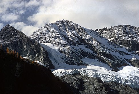
Copper Peak is an 8,964-foot (2,732-metre) mountain summit located in the Entiat Mountains, a sub-range of the North Cascades, in Chelan County of Washington State. Copper Peak is situated 80 miles northeast of Seattle in the Glacier Peak Wilderness, on land managed by the Wenatchee National Forest. Copper Peak ranks 22nd on Washington's highest 100 peaks, and 19th on the "Bulger List". The nearest higher peak is Mount Fernow, 0.88 miles (1.42 km) to the south. Precipitation runoff from the mountain and meltwater from the glacier on the southeast slope drains into nearby Lake Chelan via Railroad Creek. The first ascent of the peak was made in August 1937 by Franklin Bennet, Edgar Courtwright, and Toivo Hagman. The peak's name refers to an abandoned copper mine that once operated at the northeast base of the peak.

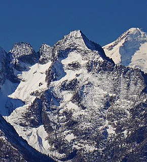
Spectacle Buttes are a pair of mountain summits located in the Entiat Mountains, a sub-range of the North Cascades, in Chelan County of Washington State. The pyramid-shaped south summit is 8,392-foot (2,558-metre) in elevation, and the lower north butte is 8,080-foot (2,460-metre) in elevation. Spectacle Buttes are situated 77 miles northeast of Seattle in the Glacier Peak Wilderness, on land managed by the Wenatchee National Forest. Spectacle Buttes ranks 78th on Washington's highest 100 peaks, 81st on the "Bulger List", and seventh-highest in the Entiat Mountains. The nearest higher peak is Marmot Pyramid on Mount Maude, 1.9 miles (3.1 km) to the west-northwest. Precipitation runoff from the peaks drains into headwaters of the Entiat River. The first ascent of the south peak was made by Rowland Tabor and Dwight Crowder on August 20, 1953.