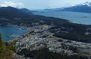
Haines is a census-designated place located in Haines Borough, Alaska, United States. It is in the northern part of the Alaska Panhandle and near Glacier Bay National Park and Preserve. As of the 2020 census, the population of the Haines CDP was 1,657, down from 1,713 in 2010; it has 79.6% of Haines Borough's total population.

The Municipality and Borough of Skagway is a first-class borough in Alaska on the Alaska Panhandle. As of the 2020 census, the population was 1,240, up from 968 in 2010. The population doubles in the summer tourist season in order to deal with the large number of summer tourists each year. Incorporated as a borough on June 25, 2007, it was previously a city in the Skagway-Yakutat-Angoon Census Area. The most populated community is the census-designated place of Skagway.
Chilkoot or The Chilkoot or variation may refer to:
The Haines Highway or Haines Cut-Off is a highway that connects Haines, Alaska, in the United States, with Haines Junction, Yukon, Canada, passing through the province of British Columbia. It follows the route of the old Dalton Trail from the port of Haines inland for about 180 km (110 mi) to Klukshu, Yukon, and then continues to Haines Junction. The highway is about 244 km (152 mi) long, of which 72 km (45 mi) is in Alaska.

The Takhinsha Mountains are a mountain range in Haines Borough and the Hoonah–Angoon Census Area in the U.S. state of Alaska, in the southeastern part of the state. They extend 40 km (25 mi) west-northwest from the northern end of the Chilkat Range to the head of Riggs Glacier, 46 km (29 mi) southwest of Skagway.

The Chilkat Range is a mountain range in Haines Borough and the Hoonah-Angoon Census Area in the U.S. state of Alaska, west of the city of Juneau.
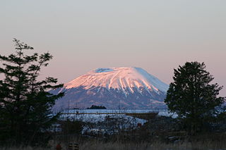
Mount Edgecumbe is located at the southern end of Kruzof Island, Alaska, about 15 miles (24 km) west of Sitka. The dormant volcano is about 9.9 miles (16 km) east of the Queen Charlotte Fault that separates the North American and Pacific Plates, and is the highest point in the Mount Edgecumbe volcanic field, an area of about 100 square miles (260 km2) on Kruzof Island that also includes Crater Ridge and Shell Mountain.

The Chilkat Pass is a mountain pass on the border of Alaska, United States, and the province of British Columbia, Canada, at the divide between the Klehini (S) and Kelsall Rivers just northwest of Haines, Alaska. At an elevation of 3510 ft, it is used by the Haines Highway and was the route used by the Dalton Trail during the days of the Klondike Gold Rush. It also marks the boundary between the Coast Mountains and Saint Elias Mountains.

The Takshanuk Mountains are a mountain range in Southeast Alaska, United States that separate the Chilkoot and Chilkat watersheds and also form the northern portion of the Chilkat Peninsula.
Leo William O'Brien was an American journalist, radio and television commentator, and politician. A Democrat, he was most notable for his seven terms of service as a member of the United States House of Representatives from New York from 1952 to 1966.
Mount Marshall is a mountain in the MacIntyre Range of the Adirondacks in the U.S. state of New York. With an elevation of 4,360 feet (1,330 m), it is the 25th highest mountain in the Adirondacks and one of the 46 High Peaks in Adirondack Park. It is located in the town of Newcomb in Essex County, flanked to the northeast by Cold Brook Pass and Iroquois Peak. Originally named for Governor DeWitt Clinton, and then for mountain guide Herbert Clark, it was renamed for wilderness activist Bob Marshall after his death. The summit can be accessed by hikers on an unmarked trail.
Mount Nesselrode, also known as Boundary Peak 98, is a 2,474 m (8,117 ft) peak in the Boundary Ranges of the Coast Mountains, located on and in part defining the border between British Columbia, Canada, and Alaska, United States. About 40 miles (64 km) north of Juneau to the west of the lower Stikine River and in the heart of the Stikine Icecap in Juneau Icefield southwest of Atlin Lake, the summit, with a prominence of 924 m (3,031 ft), is also the corner point of Alaska's Haines Borough and Juneau Borough.
Mount London, also known as Boundary Peak 100, 2,326 m (7,631 ft), is a mountain on the Alaska-British Columbia boundary in the Juneau Icefield of the Boundary Ranges of the Coast Mountains, located southwest of Atlin, British Columbia on the border with Haines Borough Alaska. Originally called Mount Atlin, it was renamed in honour of the famous author Jack London (1876–1916).

Mount Prindle is a granitic mountain in the Yukon–Tanana Uplands, and is located approximately 45 miles (72 km) north-northeast of Fairbanks, Alaska. The plutons that form the core of the Mount Prindle massif are Late Cretaceous or early Tertiary age. These plutons intruded older metamorphic rocks. Mount Prindle exhibits classic glacial landforms, unlike most of the surrounding Yukon–Tanana Uplands. It is in the Circle Mining District and many of the surrounding creeks have been or are being mined for placer gold. The area has also been prospected for tin and rare earth minerals. Mine roads and hiking trails provide access to the mountain. A 900 feet (270 m) granite wall on an eastern spur of the massif is an attraction for rock climbers.

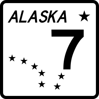
The Dalton Cache–Pleasant Camp Border Crossing connects the towns of Haines, Alaska and Haines Junction, Yukon on the Canada–United States border. Alaska Route 7 on the American side joins Yukon Highway 3 on the Canadian side as part of the Haines Highway.
Chilkat or The Chilkat, or Chilkats, may refer to:
The history of the Jews in Alaska began before the Alaska Purchase in 1867. Jews from Imperial Russia lived there periodically as fur traders, and a Jewish community has existed since the 1880s. The Klondike and Nome gold rushes attracted Jews to Alaska to seek their fortunes as miners and businessmen and resulted in the first organized Jewish communities. In the Nazi period, Jewish refugee resettlement in Alaska was seriously considered by the government, but after facing backlash, never came to be. Alaskan Jews played a significant role in business and politics before and after statehood, and have included mayors, judges, senators and governors. Today, there are Jews living in every urban area of the state.

Chilkat State Park is a 9,837-acre Alaska state park on a peninsula south of the town of Haines, Alaska between the Chilkat and Chilkoot inlets. Remote and known for the steep 14% grade gravel access road, the park offers campsites with minimal amenities and is open to fishing, hiking, boating, sea kayaking, and sightseeing. The campground is closed from October to mid-May due to winter concerns.

Mount Emmerich is a 6,877-foot-elevation (2,096-meter) mountain summit in Alaska.

