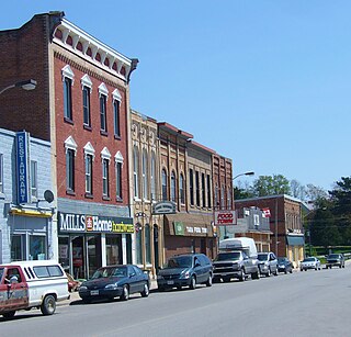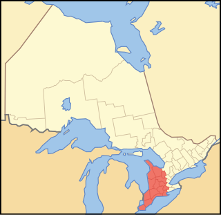
Baden is a suburban community and unincorporated place in Township of Wilmot, Regional Municipality of Waterloo in Southwestern Ontario, Canada. It has a population of around 4500 and was named after Baden-Baden, Germany. The approximate population as of 2011, as per township statistics, is 4,553.

The Municipality of Trent Hills is a township municipality in Northumberland County in Central Ontario, Canada. It is on the Trent River and was created in 2001 through the amalgamation of the municipalities of Campbellford/Seymour, Percy Township and Hastings. Thereafter it was briefly known as Campbellford/Seymour, Percy, Hastings.

Tara is an unincorporated community in the municipality of Arran–Elderslie, Bruce County, in southwestern Ontario, Canada. It is a designated place and had 1,037 residents and 458 dwellings as of the 2011 census. Tara is in geographic Arran Township and is located on the Sauble River. It has an area of 2.39 square kilometres (0.92 sq mi) and an urban area that covers 63.5 square kilometres (24.5 sq mi).

Portland is a police village and unincorporated place located in the municipal township of Rideau Lakes, United Counties of Leeds and Grenville in eastern Ontario, Canada. The community is on Ontario Highway 15 about 60 kilometres (37 mi) northeast of Ontario Highway 401 at Kingston by road, and is situated in geographic Bastard Township on the southeast side of Big Rideau Lake.

Salem is a compact rural community and unincorporated place in the incorporated township of Centre Wellington, Wellington County, in southwestern Ontario, Canada.

Chapple is a township municipality in Rainy River District in Northwestern Ontario, Canada.

Greater Madawaska is an incorporated township in Renfrew County in eastern Ontario, Canada, created on January 1, 2001, through the amalgamation of the Township of Bagot and Blythfield; the Township of Brougham; and the Township of Griffith and Matawatchan. As of 2011, it has a population of 2,518.

Jogues is a dispersed rural community and unincorporated place in geographic Way Township, Cochrane District in Northeastern Ontario, Canada. It is about 11 kilometres (6.8 mi) southwest of Hearst. Jogues is also a designated place served by a local services board.

Salem is a Dispersed Rural Community and unincorporated place in the municipality of Mono, Dufferin County in southwestern Ontario, Canada. The community is located at the intersection of 2nd Line EHS and Sideroad 5, 5.3 kilometres (3.3 mi) northeast of the town of Orangeville.

Inverary is a Compact Rural Community and unincorporated place in South Frontenac, Frontenac County in eastern Ontario, Canada. The community was originally called Storrington post office in 1845, for geographic Storrington Township in which the community lies. It was renamed to Inverary in 1856 by landowner James Campbell after Inveraray, his ancestral home in Scotland, before being officially incorporated in 1860.

Salem is a Dispersed Rural Community and unincorporated place in the municipality of South Bruce, Bruce County in southwestern Ontario, Canada. The community is in geographic Culross Township at the intersection of Bruce County Road 4 and Concession Road 12, 6 kilometres (3.7 mi) north of the community of Teeswater and 7 kilometres (4.3 mi) west of the community of Formosa, and is the location of a United Church built in 1872.

Salem is a Compact Rural Community and unincorporated place in the municipality of South Frontenac, Frontenac County in southern Ontario, Canada. The community is in geographic Bedford Township, and lies on the county border with the municipality of Rideau Lakes, United Counties of Leeds and Grenville.

Salem is a Dispersed Rural Community and unincorporated place in the municipal township of Cramahe, Northhumberland County in southern Ontario, Canada. The community is on Northumberland County Road 2 about 4 kilometres (2.5 mi) east of Colborne and 9 kilometres (5.6 mi) west of Brighton.

Bervie is an unincorporated place and Compact Rural Community in the municipality of Kincardine, Bruce County in southwestern Ontario, Canada. It is located on Ontario Highway 9, and is on the Penetangore River, which flows to Lake Huron at the town centre of Kincardine.

Sixteenmile Creek is a stream in the municipality of West Elgin, Elgin County in Southwestern Ontario, Canada. It is part of the Great Lakes Basin, and flows from a point just south of Ontario Highway 401 east of exit 129 through the community of Rodney, past the community of New Glasgow, to its mouth at the community of Port Glasgow on Lake Erie.
Salem may refer to one of seven places with that name in Ontario, Canada :

Irvine Creek is a creek in the municipality of Centre Wellington, Wellington County in southwestern Ontario, Canada. It is in the Great Lakes Basin and is a right tributary of the Grand River.

Salem is a dispersed rural community and unincorporated place in the municipality of Arran–Elderslie, Bruce County in southwestern Ontario, Canada. The community is in geographic Elderslie Township at the intersection of Concession 10 Elderslie and Sideroad 15 South Elderslie, 10 kilometres (6.2 mi) northwest of the community of Chesley and 9 kilometres (5.6 mi) northeast of the community of Paisley. The community is on Snake Creek, a tributary of the Saugeen River.

Salem Creek is a stream in the municipal township of Cramahe, Northhumberland County in Central Ontario, Canada. It is in the Great Lakes Basin and is a tributary of Lake Ontario. The creek takes its name from the community of Salem which it flows past.


