
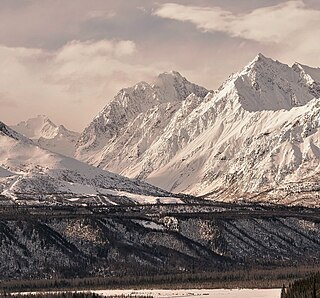
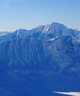
Fireweed Mountain is a prominent 6,956-foot mountain summit located in the Wrangell Mountains, in the U.S. state of Alaska. The peak is situated in Wrangell-St. Elias National Park and Preserve, immediately west of the terminus of the Kennicott Glacier, and 5 mi (8 km) west-northwest of McCarthy. Precipitation runoff from the eight-mile-long by five-mile-wide mountain drains into tributaries of the Chitina River, which in turn is part of the Copper River drainage basin. The mountain's name was given in the 1920s by Molly Gilmore, a lifelong resident of the McCarthy area, who at age 17, named the mountain for the abundance of fireweed which grew on the mountain following forest fires. Although fireweed is the most common and well-known flower in Alaska, it is not commemorated on any other Alaskan mountain. The mountain's name was officially adopted in 1966 by the U.S. Board on Geographic Names. On a clear day the summit of Fireweed Mountain offers views of Mount Blackburn to the northwest, and Regal Mountain to the northeast.

Mount Carmack is a prominent 6,808-foot-elevation (2,075-meter) mountain summit located in the Boundary Ranges of the Coast Mountains, in the U.S. state of Alaska. The peak is situated 7 mi (11 km) north-northeast of Skagway, and 3.5 mi (6 km) south of Mount Cleveland, on land managed by Tongass National Forest. As the highpoint on the divide between the Taiya River and the Skagway River, precipitation runoff from the mountain drains east into the Skagway River and west into Taiya River, both of which empty into Taiya Inlet. Although modest in elevation, relief is significant since Mount Carmack rises 6,800 feet above the Taiya valley in less than 2 mi (3 km), and 5,800 feet above Skagway valley in about 2 miles. Mount Carmack has a lower subsidiary summit, elevation 6,621 ft (2,020 m), about 0.5 mi (1 km) to the northeast of the true summit. The USGS topographic map has this lower northeast peak labelled as Mount Carmack.
Awesome Peak is an 8,645-foot-elevation (2,635-meter) mountain summit located 35 miles (56 km) east-northeast of Palmer, in the northern Chugach Mountains of Alaska. This peak of the Matanuska Valley is set midway between Anchorage and Glennallen, near mile 90 of the Glenn Highway. It is situated 15 miles (24 km) west of Matanuska Glacier and 3.7 mi (6 km) southwest of Amulet Peak. Precipitation runoff from the mountain drains into Monument and Coal creeks, which are tributaries of the Matanuska River. Topographic relief is significant as the summit rises 5,650 feet above Coal Creek in 3.75 miles (6 km) and 4,650 feet above Monument Creek in 1.9 mile (3 km). This mountain's toponym has not been officially adopted by the United States Board on Geographic Names, so it is only marked as "8645" on USGS maps.
Mount Kiev is a 7,775-foot-elevation (2,370-meter) mountain summit located in Alaska, United States.

Mount Shouplina is an 8,531-foot-elevation (2,600-meter) mountain summit located 18 miles (29 km) north-northwest of Valdez in the U.S. state of Alaska. This remote glaciated mountain is set in the Chugach Mountains on land managed by Chugach National Forest. Precipitation runoff from the mountain drains south to Prince William Sound and north to Tazlina Lake → Tazlina River → Copper River. Topographic relief is significant as the summit rises 2,100 feet (640 m) above the East Branch Columbia Glacier in 0.4 mile (0.64 km). The first ascent of the summit was made in 1985 by John Weiland, Matt Kinney, and Bob Shelton. The mountain was named in 1959 by mountaineer Lawrence E. Nielsen and the toponym was officially adopted in 1965 by the U.S. Board on Geographic Names. The word "Shouplina" is a portmanteau blending the names of the Shoup Glacier and Tazlina Glacier which flow from this mountain's south and north slopes respectively.
Mount Balchen is an 11,205-foot-elevation (3,415-meter) mountain summit in Alaska, United States.

Mount Allen is a 9,512-foot-elevation (2,899-meter) mountain summit in Alaska, United States.
Mount Leeper is a 9,603-foot-elevation (2,927-meter) mountain summit in Alaska, United States.
Mount Laurens is a 10,042-foot-elevation (3,061-meter) mountain summit in Alaska.

Mount Gakona is a 9,865-foot-elevation (3,007-meter) mountain summit in Alaska.

Mount Emmerich is a 6,877-foot-elevation (2,096-meter) mountain summit in Alaska.

Institute Peak is an 8,022-foot-elevation (2,445-meter) mountain summit in Alaska.

Mount Yukla is a 7,569-foot (2,307 m) mountain summit in Alaska, United States.
The Rowel is a 9,806-foot-elevation (2,989-meter) mountain summit in Alaska.

Mount Chichantna is a 10,893-foot-elevation (3,320-meter) mountain summit in Alaska.

Haydon Peak is an 11,924-foot-elevation (3,634-meter) mountain summit in Alaska, United States.

Alabaster Peak is an 8,065-foot-elevation (2,458-meter) mountain summit located 35 miles (56 km) east of Palmer, in the northern Chugach Mountains of Alaska. This peak of the Matanuska Valley is set midway between Anchorage and Glennallen, and can be seen from the Glenn Highway. It is situated 15 miles (24 km) west of Matanuska Glacier and 1.8 miles (2.9 km) south of Awesome Peak. Precipitation runoff from the mountain drains into Coal, Monument, and Gravel creeks, which are tributaries of the Matanuska River. Topographic relief is significant as the summit rises 3,065 feet along the west slope in one mile (1.6 km). The first ascent of the summit was made on July 4, 1970, by Robert Spurr, Bob Pelz, and Royce Purinton via the Spectrum Glacier and North Ridge. This mountain's toponym has not been officially adopted by the United States Board on Geographic Names, so it is only marked as "8065" on USGS maps.

Mount Skarland is a 10,375-foot-elevation (3,162-meter) mountain summit in Alaska, United States.

Mount Geist is a 10,716-foot-elevation (3,266-meter) mountain summit in Alaska, United States.

Rainbow Mountain is a 6,841-foot-elevation (2,085-meter) summit in Alaska, United States.


