
Mount Monadnock, or Grand Monadnock, is a mountain in the New England state of New Hampshire, known for being featured in the writings of Ralph Waldo Emerson and Henry David Thoreau. It is the most prominent mountain peak in southern New Hampshire and is the highest point in Cheshire County. It is located 62 miles (100 km) northwest of Boston and 38 miles (61 km) southwest of Concord, within the towns of Jaffrey and Dublin, New Hampshire. At 3,165 feet (965 m), Mount Monadnock is nearly 1,000 feet (305 m) higher than any other mountain peak within 30 miles (48 km) and rises 2,000 feet (610 m) above the surrounding landscape.

Mount Mitchell is the highest peak of the Appalachian Mountains and the highest peak in mainland eastern North America. It is located near Burnsville in Yancey County, North Carolina; in the Black Mountain subrange of the Appalachians, about 19 miles (31 km) northeast of Asheville. It is protected by Mount Mitchell State Park and surrounded by the Pisgah National Forest. Mount Mitchell's elevation is 6,684 feet (2,037 m) above sea level.

The Blue Ridge Parkway is a National Parkway and All-American Road in the United States, noted for its scenic beauty. The parkway, which is America's longest linear park, runs for 469 miles (755 km) through 29 Virginia and North Carolina counties, linking Shenandoah National Park to Great Smoky Mountains National Park. It runs mostly along the spine of the Blue Ridge, a major mountain chain that is part of the Appalachian Mountains. Its southern terminus is at U.S. 441 on the boundary between Great Smoky Mountains National Park and the Cherokee Indian Reservation in North Carolina, from which it travels north to Shenandoah National Park in Virginia. The roadway continues through Shenandoah as Skyline Drive, a similar scenic road which is managed by a different National Park Service unit. Both Skyline Drive and the Virginia portion of the Blue Ridge Parkway are part of Virginia State Route 48, though this designation is not signed.

Mount Diablo is a mountain of the Diablo Range, in Contra Costa County of the eastern San Francisco Bay Area in Northern California. It is south of Clayton and northeast of Danville.

Mount Katahdin is the highest mountain in the U.S. state of Maine at 5,267 feet (1,605 m). Named Katahdin by the Penobscot Native Americans, which means "The Greatest Mountain", it is located within Northeast Piscataquis, Piscataquis County, and is the centerpiece of Baxter State Park. It is a steep, tall masiff formed from a granite intrusion weathered to the surface. The flora and fauna on the mountain are typical of those found in northern New England.

Mount Jefferson State Natural Area is a 1,086-acre (4.39 km2) North Carolina state park in Ashe County, North Carolina in the United States. Located near Jefferson, North Carolina, it includes the peak of Mount Jefferson, named for Thomas Jefferson and his father Peter, who owned land nearby and surveyed the North Carolina-Virginia border in 1749. In 1974, Mount Jefferson State Natural Area was designated as a National Natural Landmark by the National Park Service.
Clingmans Dome is a mountain in the Great Smoky Mountains of Tennessee and North Carolina, in the southeastern United States. At an elevation of 6,643 feet (2,025 m), it is the highest mountain in the Smokies, the highest point in the state of Tennessee, and the highest point along the 2,174-mile (3,499 km) Appalachian Trail. It is also the third highest point in mainland Eastern North America, after the nearby Mount Mitchell and Mount Craig.

Glacier Point is a viewpoint above Yosemite Valley, in California, United States. It is located on the south wall of Yosemite Valley at an elevation of 7,214 feet (2,199 m), 3,200 feet (980 m) above Half Dome Village. The point offers a superb view of several of Yosemite National Park's well-known landmarks including Yosemite Valley, Yosemite Falls, Half Dome, Vernal Fall, Nevada Fall, and Clouds Rest.

Old Rag Mountain is a 3,284 feet (1,001 m) mountain near Sperryville in Madison County, Virginia. A part of the Blue Ridge Mountains, the peak is located within Shenandoah National Park and is the most popular hiking destination within the park.

The Long Path is a 357-mile (575 km) long-distance hiking trail beginning at the George Washington Bridge in Fort Lee, New Jersey and ending at Altamont, New York, in the Albany area. While not yet a continuous trail, relying on road walks in some areas, it nevertheless takes in many of the popular hiking attractions west of the Hudson River, such as the New Jersey Palisades, Harriman State Park, the Shawangunk Ridge and the Catskill Mountains. It offers hikers a diversity of environments to pass through, from suburbia and sea-level salt marshes along the Hudson to wilderness and boreal forest on Catskill summits 4,000 feet (1,220 m) in elevation.

Mount Tom, 1,202 feet (366 m), is a steep, rugged traprock mountain peak on the west bank of the Connecticut River 4.5 miles (7 km) northwest of downtown Holyoke, Massachusetts. The mountain is the southernmost and highest peak of the Mount Tom Range and the highest traprock peak of the 100-mile (160 km) long Metacomet Ridge. A popular outdoor recreation resource, the mountain is known for its continuous line of cliffs and talus slopes visible from the south and west, its dramatic 1,100-foot (340 m) rise over the surrounding Connecticut River Valley, and its rare plant communities and microclimate ecosystems.

Mount Oglethorpe is a mountain located in Pickens County, Georgia, USA. The southernmost peak in the Blue Ridge Mountains, the mountain has an elevation of 3,288 feet (1,002 m), making it the highest point in Pickens County.
The Monadnock-Sunapee Greenway (MSG) is a 50-mile (80 km) hiking trail that traverses the highlands of southern New Hampshire from Mount Monadnock in Jaffrey to Mount Sunapee in Newbury. Located approximately 27 miles (43 km) from the city of Concord, New Hampshire, the trail traverses a rural, heavily glaciated and metamorphic upland studded with lakes, heath barrens, the rocky summits of several monadnocks, and dense woodland of the northern hardwood forest type. The trail is maintained primarily through the efforts of the Monadnock-Sunapee Greenway Trail Club.

Mount Chapman is a mountain in the Great Smoky Mountains, located in the Southeastern United States. It has an elevation of 6,417 feet above sea level. While the mountain is located deep within the Great Smokies, the Appalachian Trail crosses its eastern slope, coming to within 200 feet (61 m) of the summit. Mount Chapman is among the 10 highest mountains in the Appalachian range, if subpeaks are not included.

The Metacomet Ridge, Metacomet Ridge Mountains, or Metacomet Range of southern New England is a narrow and steep fault-block mountain ridge known for its extensive cliff faces, scenic vistas, microclimate ecosystems, and rare or endangered plants. The ridge is an important recreation resource located within 10 miles (16 km) of more than 1.5 million people, offering four long-distance hiking trails and over a dozen parks and recreation areas, including several historic sites. It has been the focus of ongoing conservation efforts because of its natural, historic, and recreational value, involving municipal, state, and national agencies and nearly two dozen non-profit organizations.

Brace Mountain is the peak of a ridge in the southern Taconic Mountains, near the tripoint of the U.S. states of New York, Connecticut and Massachusetts. Its 2,311-foot (704 m) main summit is located in New York; it is the highest point in that state's Dutchess County.

Mount Sterling is a mountain in the Great Smoky Mountains of Haywood County, North Carolina, located in the southeastern United States. It reaches an elevation of 5,842 feet (1,781 m) above sea level. The summit is topped by an abandoned fire tower that gives stunning views of other nearby peaks.

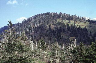
Marks Knob is a mountain in the Great Smoky Mountains, in the southeastern United States. It has an elevation of 6,169 feet (1,880 m), with 249 feet (76 m) of clean prominence. Its summit— located near the center of the Eastern Smokies amidst a dense stand of Southern Appalachian spruce-fir forest— is a popular bushwhacking destination and one of the most difficult-to-reach summits of the Southern Sixers.
County Line Road is an unimproved road between the San Antonio Valley and Fifield Ranch that closely follows the east-west divide of the Diablo Range and the County boundary of Santa Clara County, and Stanislaus County, California. This road followed the route called La Vereda del Monte, used by Californio mesteñeros and the gang of Joaquin Murrieta and other bandits and horse-thieves, and sites of three of their camps along the route are found along it. Two sites are now state park campgrounds, the last is at ranch dating back to the 1860s.


