| Mount Steller | |
|---|---|
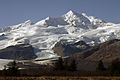
 Mount Steller (to left) in August 2003 (Mount Denison is to the right) | |
| Highest point | |
| Elevation | 7,454 ft (2,272 m) |
| Prominence | 1,600 ft (490 m) |
| Coordinates | 58°25′47″N154°23′29″W / 58.42972°N 154.39139°W |
| Geography | |
 Mount Steller Alaska | |
| Location | Katmai National Park and Preserve, Alaska, U.S. |
| Parent range | Aleutian Range |
| Geology | |
| Formed by | Subduction zone volcanism |
| Mountain type | Stratovolcano |
| Volcanic arc | Aleutian Arc |
Mount Steller is a stratovolcano in Katmai National Park in Alaska, United States. It is part of the Aleutian Range and is located on the Alaska Peninsula.
Contents
The mountain was presumably named for the naturalist Georg Wilhelm Steller. While evidence is uncertain, the volcano is believed to have erupted during the Holocene epoch. [1]