Related Research Articles

Shiselweni is a region of Eswatini, located in the south of the country. It has an area of 3,786.71 km² and a population of 204,111 (2017). Its administrative center is Nhlangano. It borders Lubombo in the northeast and Manzini Region in the northwest.
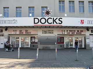
Docks is a nightclub located at Spielbudenplatz in the St. Pauli district of Hamburg, Germany. It has a capacity between 1,250 and 1,500 people. The building opened in 1900 as a cinema. Notable past performers include Bob Dylan, Black Sabbath, Metallica, Motörhead, Ramones, Red Hot Chili Peppers, Def Leppard, Ozzy Osbourne, Dio, Iron Maiden, Nine Inch Nails and Liam Gallagher.
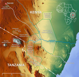
Nyiri Desert, also called The Nyika, Taru Desert, Taru desert, is a desert in southern Kenya. It is located east of Lake Magadi and between Amboseli, Tsavo West and Nairobi National Parks. A high proportion of Kajiado County's land area is covered by the Nyiri Desert. Its aridity is caused by the rain shadow of Mount Kilimanjaro.
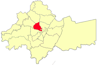
Karaçoban is a town and district of Erzurum Province in the Eastern Anatolia region of Turkey. The population was 8,837 in 2010.

Bernauer Straße is a Berlin U-Bahn station located on the U8.

Broadway Residence Hall is a postmodern dormitory at Columbia University in New York City. The building is commonly referred to by students as "Broadway". The building is nominally located at the corner of Broadway and 113th Street, though it shares its main entrance, which opens onto 114th Street, with Hogan Hall. Designed by Robert A.M. Stern Architects, it opened in 2000. Originally supposed to blend with the redbrick McKim, Mead & White buildings of the Columbia campus, Broadway Hall's design was changed to placate neighbors who wished to see it blend with local apartment buildings. In addition to housing students, its lower levels are home to a hardware store and a branch of the New York Public Library system.
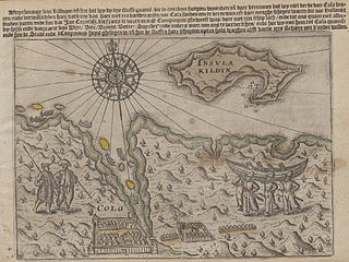
Kola Bay or Murmansk Fjord is a 57-km-long fjord of the Barents Sea that cuts into the northern part of the Kola Peninsula. It is up to 7 km wide and has a depth of 200 to 300 metres. The Tuloma, Rosta and Kola Rivers discharge into the bay.
Kozy is a village in the administrative district of Gmina Czarna Dąbrówka, within Bytów County, Pomeranian Voivodeship, in northern Poland. It lies approximately 6 kilometres (4 mi) north-east of Czarna Dąbrówka, 31 km (19 mi) north of Bytów, and 67 km (42 mi) west of the regional capital Gdańsk.
Marzewo is a village in the administrative district of Gmina Pasłęk, within Elbląg County, Warmian-Masurian Voivodeship, in northern Poland. It lies approximately 10 kilometres (6 mi) south of Pasłęk, 24 km (15 mi) south-east of Elbląg, and 57 km (35 mi) west of the regional capital Olsztyn.
The Sacramento Army Depot (SAAD) was a 485-acre (1.96 km2) facility located within current city limits, 7 miles (11 km) southeast of downtown Sacramento, California, in Sacramento County. SAAD was activated in 1941. It served as a repair facility for electronic equipment, such as night vision goggles, electronic circuit boards, and radium-dial instrumentation. The depot was deactivated after the findings of the 1988 Base Realignment and Closure Commission. The depot officially closed on March 3, 1995. On July 22, 1987, the depot was added to the National Priorities List as a Superfund site.

The Riiser-Larsen Peninsula is a large peninsula which forms the western portal to Lützow-Holm Bay and marks the separation of the Princess Ragnhild and Prince Harald Coasts. It was named after Captain Hjalmar Riiser-Larsen who discovered the peninsula in a flight from the Norvegia on 21 February 21 1931.

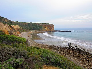
Abalone Cove State Marine Conservation Area (SMCA) and Point Vicente State Marine Reserve (SMR) are two adjoining marine protected areas that extend offshore in Los Angeles County on California's south coast. The two marine protected areas cover 19.87 sq mi (51.5 km2). The marine protected areas protect natural habitats and marine life by protecting or limiting removal of wildlife from within their boundaries. Point Vicente SMR, prohibits all take of living marine resources. Abalone Cove SMCA, prohibits take of all living marine resources, except recreational take of pelagic finfish, including Pacific bonito and white seabass by spearfishing, market squid by hand-held dip net, commercial take of coastal pelagic species and Pacific bonito by round haul net, and swordfish by harpoon.

West Lawn Cemetery is in Canton, Ohio, adjacent to the McKinley National Memorial. It was the original resting place of William McKinley until his memorial was built, and has graves of other notable Cantonians.
Dalzell is an unincorporated community in Meade County, in the U.S. state of South Dakota.
Kelsey is an extinct town in Belmont County, in the U.S. state of Ohio.
Curdton is an unincorporated community in Stoddard County, in the U.S. state of Missouri.
References
- Statoids.com, retrieved December 11, 2010
26°57′52″S31°23′48″E / 26.96444°S 31.39667°E
| | This Eswatini location article is a stub. You can help Wikipedia by expanding it. |