White Stone is a town in Lancaster County, Virginia, United States. The population was 352 at the 2010 census. The name "White Stone" refers to the accumulations of white stones in the area's waterways. The stones were dumped there in the colonial era by British ships that dumped their stone ballast to make room for cargo like tobacco to carry back to England.

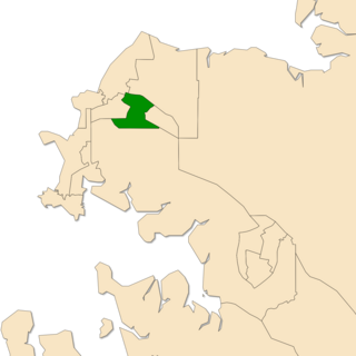
Sanderson is an electoral division of the Legislative Assembly in Australia's Northern Territory. It was first created in 1974, and derives its name from the name initially given to the area in 1879, before its division into suburbs. Sanderson is an urban electorate, covering 5.51 km² and taking in the Darwin suburbs of Anula, Marrara, Wulagi and part of Malak. There were 5,546 people enrolled in the electorate as of August 2016.

Labské Chrčice is a village in the Pardubice Region of the Czech Republic. It has around 140 inhabitants.

The Kordopulov House is a large Bulgarian National Revival house in the southwestern Bulgarian town of Melnik. It was built in 1754 specifically for wine production and was bought by the rich and known Greek merchant Manolis Kordopulos. The house, possibly the largest of its kind and period, is located in the town's eastern part and consists of a ground floor that includes a wine cellar, a semi-basement for economic needs and a bay floor intended to be inhabited.

The Fort Yuma Indian Reservation is a part of the traditional lands of the Quechan people. Established in 1884 from the former Fort Yuma, the reservation, at 32°47′04″N114°38′43″W, has a land area of 178.197 km2 (68.802 sq mi) in southeastern Imperial County, California, and western Yuma County, Arizona, near the city of Yuma, Arizona. Both the county and city are named for the tribe. As of the 2010 Census the population was 2,189. In 1910, the community of Bard, California was created after the eastern part of the reservation was declared surplus under the Dawes Act.

Jarki is a village in the administrative district of Gmina Rojewo, within Inowrocław County, Kuyavian-Pomeranian Voivodeship, in north-central Poland. It lies approximately 13 kilometres (8 mi) north-east of Rojewo, 24 km (15 mi) north-east of Inowrocław, 16 km (10 mi) west of Toruń, and 31 km (19 mi) south-east of Bydgoszcz.

Arbat is a village in the Ararat Province of Armenia.

Lahıc is a village in the Goygol Rayon of Azerbaijan.
Tomaszewo is a village in the administrative district of Gmina Nowe Miasto, within Płońsk County, Masovian Voivodeship, in east-central Poland.
Jastrzębiec is a village in the administrative district of Gmina Krotoszyn, within Krotoszyn County, Greater Poland Voivodeship, in west-central Poland.

Ming Kum is an at-grade MTR Light Rail stop located at Ming Kum Roadi n Tuen Mun District, near Shan King Estate. It began service on 18 September 1988 and belongs to Zone 2. It serves Shan King Estate and nearby industrial areas.

Przystań is a village in the administrative district of Gmina Węgorzewo, within Węgorzewo County, Warmian-Masurian Voivodeship, in northern Poland, close to the border with the Kaliningrad Oblast of Russia. It lies approximately 8 kilometres (5 mi) west of Węgorzewo and 89 km (55 mi) north-east of the regional capital Olsztyn.
Jawor is a settlement in Gmina Wąsosz, Góra County, Lower Silesian Voivodeship, in south-western Poland.
Trù Hựu is a commune (xã) and village in Lục Ngạn District, Bắc Giang Province, in northeastern Vietnam.

Kazbegi is a district of Georgia, in the region of Mtskheta-Mtianeti. According to the 2014 Census a population of the district compose 3,795 inhabitants. Area of the district is 1,081.7 km². The main settlement is Stepantsminda, accounting for about half of the total population.

Odense Teater is a theater in the city of Odense in Denmark. It can be dated back to 1796 which makes it Denmark's second oldest theater. It is one of the country's three main theaters.
El Houaita is a town and commune in Laghouat Province, Algeria. According to the 1998 census it has a population of 1,290.
Borgonovo is a frazione in the Province of Teramo in the Abruzzo region of Italy.

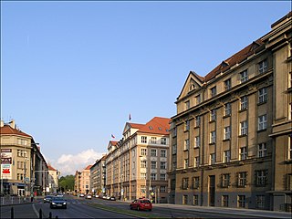
Bubeneč is a district in the north-west of Prague. 52% of the district is in Prague 7, but most of the built-up area is in Prague 6. Sparta Prague football club and their stadium Generali Arena is situated at the south-eastern edge of Bubeneč, and the district also covers Stromovka park and Výstaviště. The name Bubeneč is masculine, although Czech grammar rules also allow its use as a feminine.
Koh Romdual is an island approximately 20 kilometers outside of Phnom Penh, Cambodia. It is located in the Tonle Bassac river at 11°23′54″N105°00′48″E. Koh Romdual has undergone name changes, and is commonly referred to as Kor Island or Koh Kor.


