Muddy Creek Formation

Last updated
Muddy Creek Formation
Stratigraphic range: Neogene
Bulletin 798 Plate11A Typical section of Muddy Creek Formation.jpg
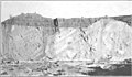
Muddy Creek Formation. Gravel opening at top. Height of section about 200 feet.
TypeSedimentary
Sub-unitsFortification Basalt Member (AZ, NV), Hualapai Limestone Member (AZ).
Overlies Horse Spring Formation
Location
Region Arizona, California, Nevada, Utah
Country United States
Type section
Named for Muddy Creek
Named byChester Stock (1921) [1]

The Muddy Creek Formation is a geologic formation in Arizona, California, Nevada, and Utah. It preserves fossils dating back to the Neogene period. [2]

Contents

Distribution and General Expression

The following description is from USGS Bulletin 798 by C. R. Longwell in 1928: [3]

In all the large intermontane valleys adjacent to the Muddy Mountains and neighboring ranges there are thick clays or silts and associated deposits that have been relatively little disturbed by crustal deformation. As a rule they form belts from a fraction of a mile to several miles wide on each side of present stream valleys, above which the clay outcrops rise to a maximum height of approximately 600 feet. Adjacent to the high lands they feather out, lapping up on the older rocks. Between the Muddy and Virgin Mountains the area occupied by the clays is from 9 to 12 miles wide. South of St. Thomas this large area is divided into two nearly equal belts by Virgin River, and to the north the clays are cut by the converging Muddy and Virgin Valleys, each of which leaves a comparatively narrow strip of the deposits bordering the mountains. Between the streams the clays occupy a large triangular area extending more than 15 miles to the Mormon Mountains. In California Wash, the clay exposures extend a maximum of more than 10 miles to the ranges on the west, and they form wide belts bordering Meadow Valley Wash and the upper part of Muddy Creek. They have invaded St. Thomas Gap in places, and in the broad Grand Wash Valley they are exposed wherever the surface waste has been sufficiently dissected. In a word, the intermontane areas occupied by clays are nearly equal to the areas of the mountain ranges. However, these broad belts do not show continuous clay outcrops, for the clays are largely covered by a veneer of varying thickness formed from more recent waste that was used in building aggradation levels at several altitudes. The clays are conspicuous beneath the waste in the sides of the large valleys and small washes and in extensive badland tracts where the later capping has been stripped away.

Owing to many interbedded layers of sandstone more or less firmly cemented, the clays tend to stand in steep fronts along wash courses. The edges of the sandy layers are visible in all sections, standing out as narrow shelves or forming a horizontal banding almost concealed by clay carried from above and plastered on the slope by infrequent rains. In detail the carved surfaces have an intricate but typical pattern, many times repeated. Steep slopes are dissected into long parallel spurs, and these subdivide repeatedly into steep spurs of many orders, all with rounded upper surfaces and separated by V-shaped trenches. From a distance the spurs resemble irregular columns. In places they are interrupted by persistent shelves formed on sandstone layers of unusual resistance, below which the typical patterns reappear.

See also

Related Research Articles

Intermontane Plateaus

The Intermontane Plateaus of the Western United States is one of eight U.S. Physiographic regions (divisions) of the physical geography of the contiguous United States. The region is composed of intermontane plateaus and mountain ranges. It is subdivided into physiographic provinces, which are each subdivided into physiographic sections.

Badlands Type of heavily eroded terrain

Badlands are a type of dry terrain where softer sedimentary rocks and clay-rich soils have been extensively eroded. They are characterized by steep slopes, minimal vegetation, lack of a substantial regolith, and high drainage density. Ravines, gullies, buttes, hoodoos and other such geologic forms are common in badlands.

Geology of the Zion and Kolob canyons area Geology of Zion National Park in Utah

The geology of the Zion and Kolob canyons area includes nine known exposed formations, all visible in Zion National Park in the U.S. state of Utah. Together, these formations represent about 150 million years of mostly Mesozoic-aged sedimentation in that part of North America. Part of a super-sequence of rock units called the Grand Staircase, the formations exposed in the Zion and Kolob area were deposited in several different environments that range from the warm shallow seas of the Kaibab and Moenkopi formations, streams and lakes of the Chinle, Moenave, and Kayenta formations to the large deserts of the Navajo and Temple Cap formations and dry near shore environments of the Carmel Formation.

Colorado Plateau Plateau in the Four Corners region of the Southwest United States

The Colorado Plateau, also known as the Colorado Plateau Province, is a physiographic and desert region of the Intermontane Plateaus, roughly centered on the Four Corners region of the southwestern United States. This province covers an area of 336,700 km2 (130,000 mi2) within western Colorado, northwestern New Mexico, southern and eastern Utah, northern Arizona, and a tiny fraction in the extreme southeast of Nevada. About 90% of the area is drained by the Colorado River and its main tributaries: the Green, San Juan, and Little Colorado. Most of the remainder of the plateau is drained by the Rio Grande and its tributaries.

Meadow Valley Wash Southern Nevada stream

The Meadow Valley Wash is a southern Nevada stream draining the Meadow Watershed that is bordered on three sides by the Great Basin Divide. The wash's Lincoln County headpoint is in the Wilson Creek Range, and the wash includes two upper confluences. Panaca is along the upper wash, and downstream of Caliente is the wash's confluence with its east fork. Just prior to the junction with the Muddy River, the wash flows from Lincoln County into northeastern Clark County. It flows into the Muddy in the Moapa Valley just west of Glendale adjacent to Interstate 15 approximately 40 miles (64 km) northwest of Las Vegas.

Geology of the Capitol Reef area

The exposed geology of the Capitol Reef area presents a record of mostly Mesozoic-aged sedimentation in an area of North America in and around Capitol Reef National Park, on the Colorado Plateau in southeastern Utah.

Geology of the Death Valley area Geology of the area in California and Nevada

The exposed geology of the Death Valley area presents a diverse and complex set of at least 23 formations of sedimentary units, two major gaps in the geologic record called unconformities, and at least one distinct set of related formations geologists call a group. The oldest rocks in the area that now includes Death Valley National Park are extensively metamorphosed by intense heat and pressure and are at least 1700 million years old. These rocks were intruded by a mass of granite 1400 Ma and later uplifted and exposed to nearly 500 million years of erosion.

North American Cordillera North American portion of the American Cordillera mountain chain

The North American Cordillera, sometimes also called the Western Cordillera of North America, the Western Cordillera or the Pacific Cordillera, is the North American portion of the American Cordillera, the mountain chain system (cordillera) along the western coast of the Americas. The North American Cordillera covers an extensive area of mountain ranges, intermontane basins and plateaus in Western/Northwestern Canada, Western United States and Mexico, including much of the territory west of the Great Plains.

Mount Hood (California)

Mount Hood, also known as Hood Mountain is a mountain near the southeastern edge of Santa Rosa, California at the northeast of the Sonoma Valley and attains a height of 2,733 feet (833 m). The original name was Mount Wilikos, an Indian name meaning "willows." Most of the drainage from Mount Hood contributes to the headwaters of Sonoma Creek. A prominent feature is the extensive rock face visible on the upper half of the mountain as viewed from State Route 12. The habitats on the mountain include mixed oak forest, pygmy forest, chaparral and riparian zones. In prehistoric times the slopes of Mount Hood were inhabited by a division of the Yuki tribe. Most of Mount Hood is within the Hood Mountain Regional Park maintained by Sonoma County. Mount Hood is part of the inner coast Mayacamas Range, and lies mostly within Sonoma County, with a part of the mountain geographically within Napa County. Mount Hood affords overlooks of the Pacific Ocean, San Francisco Bay and "a spectacular view east to the Sierra Nevada Range."

The Canyon Lands Section of the Colorado Plateau is a physiographic section of the larger Colorado Plateaus province, which in turn is part of the larger Intermontane Plateaus physiographic division in the Western United States

The Black Mountains, a mid-Miocene formation, in Nevada are a series of rugged, arid rocky volcanic mountains ranging in elevations to 3310 ft. The range lies on the north shore of Lake Mead, at the southwest corner of the Overton Arm, about 25 mi south of Overton, Nevada.

Northern Basin and Range ecoregion

The Northern Basin and Range ecoregion is a Level III ecoregion designated by the United States Environmental Protection Agency (EPA) in the U.S. states of Oregon, Idaho, Nevada, Utah, and California. It contains dissected lava plains, rolling hills, alluvial fans, valleys, and scattered mountain ranges in the northern part of the Great Basin. Although arid, the ecoregion is higher and cooler than the Snake River Plain to the north and has more available moisture and a cooler climate than the Central Basin and Range to the south. Its southern boundary is determined by the highest shoreline of Pleistocene Lake Bonneville, which once inundated the Central Basin and Range. The western part of the region is internally drained; its eastern stream network drains to the Snake River system.

Vaca Mountains

The Vaca Mountains are a mountain range in Napa and Solano Counties, California that is one of the California Coast Ranges. They represent the easternmost of the Inner Coast Ranges in north−central California, and divide the Suisun Valley on their west, from the Sacramento Valley on their east.

Aztec Sandstone Early Jurassic geological formation in the Mojave Desert, United States

The Aztec Sandstone is an Early Jurassic geological formation of primarily eolian sand from which fossil pterosaur tracks have been recovered. The formation is exposed in the Mojave Desert of Arizona, California and Nevada.

Trout Creek Mountains Mountain in United States of America

The Trout Creek Mountains are a remote, semi-arid Great Basin mountain range mostly in southeastern Oregon and partially in northern Nevada in the United States. The range's highest point is Orevada View Benchmark, 8,506 feet (2,593 m) above sea level, in Nevada. Disaster Peak, elevation 7,781 feet (2,372 m), is another prominent summit in the Nevada portion of the mountains.

The Date Creek Mountains are a short, arid range in southwest Yavapai County, Arizona. Congress is on its southeast foothills, and Wickenburg lies 15 mi (24 km) southeast.

Course of the Colorado River Route and confluences of the Colorado River in the United States and Mexico

The Colorado River is a major river of the western United States and northwest Mexico in North America. Its headwaters are in the Rocky Mountains where La Poudre Pass Lake is its source. Located in north central Colorado it flows southwest through the Colorado Plateau country of western Colorado, southeastern Utah and northwestern Arizona where it flows through the Grand Canyon. It turns south near Las Vegas, Nevada, forming the Arizona–Nevada border in Lake Mead and the Arizona–California border a few miles below Davis Dam between Laughlin, Nevada and Needles, California before entering Mexico in the Colorado Desert. Most of its waters are diverted into the Imperial Valley of Southern California. In Mexico its course forms the boundary between Sonora and Baja California before entering the Gulf of California. This article describes most of the major features along the river.

Callville, Nevada Human settlement in United States of America

Callville is a former settlement of Clark County in the U.S. state of Nevada. Abandoned in 1869, it was submerged under Lake Mead when the Colorado River was dammed, Callville Bay retaining the name. At one time, it was noted to be the southernmost outpost of the Mormon settlement.

Mormon Road, also known to the 49ers as the Southern Route, of the California Trail, was a seasonal wagon road first pioneered by a Mormon party from Salt Lake City, Utah led by Jefferson Hunt, that followed the route of Spanish explorers and the Old Spanish Trail across southwestern Utah, northwestern Arizona, southern Nevada and the Mojave Desert of California to Los Angeles in 1847. From 1855, it became a military and commercial wagon route between California and Utah, called the Los Angeles – Salt Lake Road. In later decades this route was variously called the "Old Mormon Road", the "Old Southern Road", or the "Immigrant Road" in California. In Utah, Arizona and Nevada it was known as the "California Road".

The geology of Nevada began to form in the Proterozoic at the western margin of North America. Terranes accreted to the continent as a marine environment dominated the area through the Paleozoic and Mesozoic periods. Intense volcanism, the horst and graben landscape of the Basin and Range Province originating from the Farallon Plate, and both glaciers and valley lakes have played important roles in the region throughout the past 66 million years.

References

  1. Chester Stock (1 November 1921). "Later Cenozoic mammalian remains from the Meadow Valley region, southeastern Nevada". American Journal of Science . 2 (11): 250–264. doi:10.2475/AJS.S5-2.11.250. ISSN   0002-9599. Wikidata   Q94705976.
  2. Various Contributors to the Paleobiology Database. "Fossilworks: Gateway to the Paleobiology Database" . Retrieved 17 December 2021.{{cite web}}: |author= has generic name (help)
  3. Chester R. Longwell (1928). "Geology of the Muddy Mountains, Nevada, with a section through the Virgin Range to the Grand Wash Cliffs, Arizona" (PDF). U.S. Geological Survey Bulletin. 798. doi:10.3133/B798. ISSN   8755-531X. Wikidata   Q57902798.