Mulanje Mountain Forest Reserve

Last updated
Mulanje Mountain Mulanje.jpg
Mulanje Mountain

Mulanje Mountain Forest Reserve is a nature reserve founded in 1927 in Malawi. The reserve covers 56,317 hectares. [1] It is operated by the Mulanje Mountain Conservation Trust. The reserve was designated a biosphere reserve by UNESCO in 2000. [2]

Contents

Geography

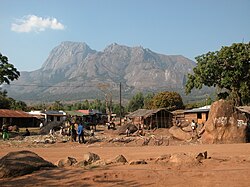
Mulanje Massif rises abruptly from the plains to a high plateau at 1800-1900m, surmounted by rocky peaks. Sapitwa Peak is the highest peak on the plateau and the highest peak in Malawi, with an altitude of 3002m above sea level. It is surrounded by densely populated plains situated at 600m-700m above sea level.[ citation needed ]

The mountain is composed of syenite, quartz-syenite and granite rock materials. This forms a massif of approximately 500 km2.

The structure and altitude of the mountain create unique climate for the area, which is characterised by high rainfall from November to April. Moisture-laden Chiperoni winds from the Indian Ocean cool and condense as they climb the mountain's southern slopes, creating fogs that nourish lush forests and tea plantations. This climate favours the development of unique ecology of rare and endemic life forms which contribute to the massif's high biodiversity.[ citation needed ]

Fauna and flora

Mulanje Massif is an enclave of Afromontane flora and fauna, which occupies Africa's high altitude areas and is distinctive from the neighboring lowlands. Mulanje is home so many threatened and endangered species, and some endemic ones. The endemic tree Widdringtonia whytei , known as Mulanje Cedar or Mulanje Cypress, has been so heavily logged that it is considered endangered and the park contains the last remaining stands of this tree. Distinctive highland birds include the Thyolo alethe (Chamaetylas choloensis) and White-winged Apalis (Apalis chariessa). Other distinctive species include the limbless burrowing skink Melanoceps ater and Ruo River Screeching Frog (Arthroleptis francei), and the endemic Mount Mulanje Pygmy Chameleon (Rhampholeon platyceps) and Mulanje Chameleon (Nadzikambia mlanjensis).

The land around the park is threatened by growing population, land use patterns such as forest clearing for farming and firewood, and invasive species such as Mexican Pine (Pinus patula) and Himalayan raspberry (Rubus ellipticus). [3]

Related Research Articles

<span class="mw-page-title-main">Geography of Malawi</span> Geographical features of Malawi

Malawi is a landlocked country in southeast Africa. It is wholly within the tropics; from about 9°30S at its northernmost point to about 17°S at the southernmost tip. The country occupies a thin strip of land between Zambia and Mozambique, extending southwards into Mozambique along the valley of the Shire River. In the north and north east it also shares a border with Tanzania. Malawi is connected by rail to the Mozambican ports of Nacala and Beira. It lies between latitudes 9° and 18°S, and longitudes 32° and 36°E.

<span class="mw-page-title-main">Mulanje Massif</span>

The Mulanje Massif, also known as Mount Mulanje, is a large inselberg in southern Malawi. Sapitwa Peak, the highest point on the massif at 3,002 m, is the highest point in Malawi. It lies 65 km east of Blantyre, rising sharply from the surrounding plains of Phalombe and the Mulanje district.

<span class="mw-page-title-main">Shire Highlands</span> Plateau in southern Malawi

The Shire Highlands are a plateau in southern Malawi, located east of the Shire River. It is a major agricultural area and the most densely populated part of the country.

<span class="mw-page-title-main">Zomba Plateau</span> Mountain in southern Malawi

The Zomba Plateau, also called the Zomba Massif, is a mountain of the Shire Highlands in southern Malawi. Its total area is about 130 square kilometres (50 sq mi), with a highest point of 2,087 metres (6,847 ft).

<span class="mw-page-title-main">Bale Mountains National Park</span> National park in Oromia Region, Ethiopia

Bale Mountains National Park (BMNP) is a national park in Ethiopia. The park encompasses an area of approximately 2,150 km2 (830 sq mi) in the Bale Mountains and Sanetti Plateau of the Ethiopian Highlands.

<span class="mw-page-title-main">Mount Nimba Strict Nature Reserve</span> Protected area in Guinea and Côte dIvoire

Mount Nimba Strict Nature Reserve is a protected area and UNESCO World Heritage Site located in both Guinea and Côte d'Ivoire, extending over a total of area of 175.4 km2, with 125.4 km2 in Guinea, and 50 km2 in Côte d'Ivoire. The reserve covers significant portions of the Nimba Range, a geographically unique area with unusually rich flora and fauna, including exceptional numbers of single-site endemic species, such as Nimbaphrynoides, the Nimba otter shrew, and multiple species of horseshoe bats. Its highest peak is Mount Richard-Molard at 1,752 m (5,750 ft), which is the highest peak of both countries.

The Central Balkan National Park lies in the heart of Bulgaria, nestled in the central and higher portions of the Balkan Mountains. Its altitude varies from 550 m. near the town of Karlovo to 2376 m. at Botev Peak, the highest summit in the mountain range. It was established on 31 October 1991. The Central Balkan National Park is the third largest protected territory in Bulgaria, spanning an area of 716.69 km² with total length of 85 km from the west to the east and an average width of 10 km. It occupies territory from 5 of the 28 provinces of the country: Lovech, Gabrovo, Sofia, Plovdiv and Stara Zagora. The national park includes nine nature reserves covering 28% of its territory: Boatin, Tsarichina, Kozya Stena, Steneto, Severen Dzhendem, Peeshti Skali, Sokolna, Dzhendema and Stara Reka.

<span class="mw-page-title-main">Madagascar dry deciduous forests</span> Tropical dry forest ecoregion in Madagascar

The Madagascar dry deciduous forests represent a tropical dry forest ecoregion situated in the western and northern part of Madagascar. The area has high numbers of endemic plant and animal species but has suffered large-scale clearance for agriculture. They are among the world's richest and most distinctive dry forests and included in the Global 200 ecoregions by the World Wide Fund. The area is also home to distinctive limestone karst formations known as tsingy, including the World Heritage Site of Bemaraha.

<span class="mw-page-title-main">Taita Hills</span>

The Taita Hills, sometimes also spelled as Teita Hills, are a mountain range located in the Taita-Taveta County in south-eastern Kenya. The hills consist of three massifs: Dawida, Sagalla in the southern side of Voi township and Kasigau in the south near the border of Tanzania. The Dawida massif is the largest and tallest of the three, with an altitude of 2,228 metres (7,310 ft) above sea level at its highest peak, Vuria. Dabida has three other main peaks: Iyale, Wesu, and Susu.

<span class="mw-page-title-main">Cameroonian Highlands forests</span>

The Cameroonian Highlands forests, also known as the Cameroon Highlands forests, are a montane tropical moist broadleaf forest ecoregion located on the range of mountains that runs inland from the Gulf of Guinea and forms the border between Cameroon and Nigeria. This is an area of forest and grassland which has become more populous as land is cleared for agriculture.

<i>Widdringtonia whytei</i> Species of conifer

Widdringtonia whytei, the Mulanje cedar or Mulanje cypress, is a species of conifer native to Malawi, where it is endemic to the Mulanje Massif at altitudes of 1,830–2,550 m. It has become endangered as a result of over-harvesting for its wood, and an increase in the frequency of wildfires due to human activity.

<i>Arthroleptis francei</i> Species of frog

Arthroleptis francei is a species of frog in the family Arthroleptidae. It is found in Mount Mulanje in southern Malawi and in Mount Namuli and Mount Mabu in northern Mozambique. Records from the Zomba Massif (Malawi) require confirmation. Common names Ruo River screeching frog and France's squeaker have been coined for it.

Oreocnemis phoenix, the Mulanje red damsel, is a species of damselfly in the family Platycnemididae. It is endemic to the slopes of Mount Mulanje in Malawi, occurring near montane streams at altitudes of 1,800-2,200 m.

The Massif de la Hotte is a mountain range in southwestern Haiti, on the Tiburon Peninsula. About 2.5 million years ago, Massif de la Hotte was separated from the Massif de la Selle by a deep, wide sea channel, and formed a separate island. This resulted in a hotbed of endemism in la Hottes bird, plant, and reptile communities. The Massif de la Hotte is subdivided into the Oriental la Hotte in the East, the central la Hotte and the Occidental la Hotte on the Western tip of the Tiburon peninsula. The Occidental la Hotte is relatively remote and is one of the most biologically diverse and significant areas of all of Hispaniola. It also supports some of the last stands of Haiti's dense cloud forest on its peaks.

<span class="mw-page-title-main">Mount Namuli</span>

Mount Namuli is the second highest mountain in Mozambique and the highest in the Province of Zambezia. It is 2,420 m (7,940 ft) high and was measured, surveyed and described in 1886 by Henry Edward O'Neill, the British consul in Mozambique. The Namuli massif consists of a level plateau with the granite dome of Mount Namuli above. The area was historically clad in tropical rainforest and is an important biodiversity hotspot with many endemic species of animals and plants. The lower slopes are now mainly used for the cultivation of tea and the middle slopes for other agricultural purposes, with indigenous forest now mostly restricted to the higher parts and corridors along water courses.

<span class="mw-page-title-main">South Malawi montane forest–grassland mosaic</span>

The South Malawi montane forest–grassland mosaic is an ecoregion of Malawi.

<span class="mw-page-title-main">Ziama Massif</span>

The Ziama Massif is a forested mountain range in Nzérékoré Region of southeastern Guinea.

<span class="mw-page-title-main">Guinean montane forests</span>

The Guinean montane forests are a tropical moist broadleaf forest ecoregion of West Africa.

<span class="mw-page-title-main">Nimba Range</span> Southern extent of the Guinea highlands

The Nimba Range forms part of the southern extent of the Guinea Highlands. The highest peak is Mount Richard-Molard on the border of Côte d'Ivoire and Guinea, at 1,752 m (5,748 ft). "Mount Nimba" may refer either to Mount Richard-Molard or to the entire range. Other peaks include Grand Rochers at 1,694 m (5,558 ft), Mont Sempéré at 1,682 m (5,518 ft), Mont Piérré Richaud at 1,670 m (5,480 ft), Mont Tô at 1,675 m (5,495 ft), and Mont LeClerc 1,577 m (5,174 ft), all of them are located in Guinea. Mount Nimba Strict Nature Reserve of Guinea and Côte d'Ivoire covers significant portions of the Nimba Range.

<span class="mw-page-title-main">Clayoquot Sound Biosphere Reserve</span> UNESCO Biosphere Reserve in British Columbia, Canada

Clayoquot Sound Biosphere Reserve is a UNESCO Biosphere Reserve situated in Clayoquot Sound on the west coast of Vancouver Island in British Columbia, Canada. A diverse range of ecosystems exist within the biosphere reserve boundaries, including temperate coastal rainforest, ocean and rocky coastal shores.

References

  1. Mauambeta, Daulos (2010). Status of Forests and Tree Management in Malawi: A Position Paper Prepared for the Coordination Union for Rehabilitation of the Environment (CURE). CURE Technical Report. September 2010 DOI: 10.13140/2.1.3497.7926
  2. "Mount Mulanje". UNESCO Man and Biosphere Program. Accessed 26 August 2019.
  3. "South Malawi montane forest-grassland mosaic". World Wildlife Fund. Accessed 11 August 2019.

15°55′00″S35°34′10″E / 15.9167°S 35.5694°E / -15.9167; 35.5694