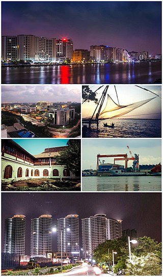
Kochi, also known as Cochin is a major port city on the Malabar Coast of India bordering the Laccadive Sea, which is a part of the Arabian Sea. It is part of the district of Ernakulam in the state of Kerala and is commonly referred to as Ernakulam. Kochi is the most densely populated city in Kerala. As of 2011, it has a corporation limit population of 677,381 within an area of 94.88 km2 and a total urban population of more than of 2.1 million within an area of 440 km2, making it the largest and the most populous metropolitan area in Kerala. Kochi city is also part of the Greater Cochin region and is classified as a Tier-II city by the Government of India. The civic body that governs the city is the Kochi Municipal Corporation, which was constituted in the year 1967, and the statutory bodies that oversee its development are the Greater Cochin Development Authority (GCDA) and the Goshree Islands Development Authority (GIDA). The current metropolitan limits of Kochi include the mainland Ernakulam, Fort Kochi, the suburbs of Edapally, Kalamassery, Aluva and Kakkanad to the northeast; Tripunithura to the southeast; and a group of islands closely scattered in the Vembanad Lake.

Ernakulam, IPA: [erɐɳɐːguɭɐm]; ISO: Eṟaṇākuḷaṁ, in Malayalam: എറണാകുളം), is one of the 14 districts in the Indian state of Kerala, that takes its name from the eponymous city division in Kochi. It is situated in the central part of the state, spans an area of about 3,000 square kilometres (1,200 sq mi), and is home to over 9% of Kerala's population. Its headquarters are located at Kakkanad. The district includes Kochi, also known as the commercial capital of Kerala, which is famous for its ancient Churches, Hindu temples, synagogues and mosques. The district includes the largest metropolitan region of the state: Greater Cochin. Ernakulam is the district that yields the most revenue and the largest number of industries in the state. Ernakulam is the third most populous district in Kerala, after Malappuram and Thiruvananthapuram. The district also hosts the highest number of international and domestic tourists in Kerala state.

Vembanad is the longest lake in India, as well as the largest lake in the state of Kerala. The lake has an area of 230 square kilometers and a maximum length of 96.5 km. Spanning several districts in the state of Kerala, it is known as Vembanadu Lake in Kottayam, Vaikom, Changanassery, Punnamada Lake in Alappuzha, Punnappra, Kuttanadu and Kochi Lake in Kochi. Several groups of small islands including Vypin, Mulavukad, Maradu, Udayamperoor, Vallarpadam, Willingdon Island are located in the Kochi Lake portion. Kochi Port is built around the Willingdon Island and the Vallarpadam island.

Vypin is one of the group of islands that form part of the city of Kochi (Cochin), in the Indian state of Kerala. Vypin forms a barrier island which lies between the Arabian Sea in the west and the Cochin backwaters formed by the various distributaries of Periyar river, in the east. The northernmost end of the island lies on the estuary of the Periyar river in Muziris (Kodungallur), and the southernmost end in the mouth of the Cochin Backwaters in Kalamukku near Fort Vypin. The island is about 27 kilometres (17 mi) long and is connected to mainland Kochi by a series of bridges known as the Goshree bridges, which start at Kalamukku in Vypin, touch other two islands and then finish at Marine Drive covering a total distance of around three km (1.9 mi). Vypin is 58th most densely populated islands in the world. Njarakkal is one of the most densely populated locations within Vypin.
North Paravur. formerly known as Paravur or Parur, is a municipality and suburb in Ernakulam district in the Indian state of Kerala. It is a northern suburb of the city of Kochi and is situated around 20 km from the city centre. It is also the first place in India to use electronic voting machine during the by-elections in 1982.
The Gundu Island is one of the many islands that make up the city of Kochi, Kerala, India. The November 1967 amalgamation order of the Kerala Legislative Assembly declared Gundu Island as part of Kochi. Gundu is the smallest island around Kochi with an area of 5 acres (20,000 m2) surrounded by coconut trees. The Island lies between Vypin and Vallarpadam islands. The island can be reached from Vypin island only by boat.
Kochi is a major port city in the Indian state of Kerala. The city is widely known as the commercial or economic capital of the state of Kerala.
Vallarpadam is one among the group of islands, that form part of Kochi, in the state of Kerala, India. It is situated in the Vembanad Lake, locally known as The Kochi Lake and has a population of over 10,000. Vallarpadam is one of the two islands, the other being Willingdon Island, around which the Port of Kochi is situated. The International Container Transshipment Terminal of the port is situated entirely in Vallarpadam island. Vypin island lies on its west side and Mulavukad island lies to its east.
Cheranallur or Cheranellore or Cheranelloor is a suburb of Kochi city in the state of Kerala, India and lies on the banks of the Periyar River. According to tradition, the area was named by its earlier inhabitants who found this place very fertile and beautiful. The name in its local language Malayalam means "Good Village of Cheras".

Mulavukad, also known locally as Bolgatty Island, is one of the islands that forms part of the city of Kochi in Kerala, India. It is situated in the Mulavukad Grama Panchayat. Vypin island and Vallarpadam island lie on its west side and Vaduthala lie to its east. Mulavukad is connected to mainland Ernakulam & Vallarpadam by the Goshree bridges and to Container terminal road at north side to connect to Kalamassery and Aluva side. Easy connection to the CBD, Northern and Southern side of Cochin city make the Island unique among other Goshree Islands.

The National Shrine Basilica of Our Lady of Ransom aka Vallarpadam Basilica located in Vallarpadam, a suburb in Ernakulam, in the city of Kochi, is a minor basilica and a major Christian pilgrimage centre in India. Around 5 million people visit the basilica every year. It is the most important Marian shrine in India. People from all parts of the world irrespective of caste or creed go to the church to seek the blessings of the Blessed Virgin Mary, mother of Jesus, popularly known as "Vallarpadathamma".
Kuzhuppilly is a suburb of Kochi city and a tourist destination in Vypin Island in Kerala, India. The areas in Kuzhuppilly village are Pallathamkulangara, Cheruvaipu, Thundippuram, Manappally, and Ayyampilly.
Mulakulam is a village spread over the Kottayam and Ernakulam districts of Kerala, India, and is situated on the banks of the River Muvattupuzha. Mulakulam lies in one municipality viz Piravom municipality and Mulakulam grama panchayath. While Mulakulam North falls under the purview of Piravom municipality in Ernakulam District, Mulakulam South is governed by the Mulakulam panchayat of Kottayam district. The village is located about 38 kilometers from both Kottayam town and Kochi city. Piravom and Elanji is the nearest town. The population of this village is about 22360 people.

Marakkara is a grama panchayath in Kuttippuram Block Panchayat, Tirur Taluk, Malappuram district in the state of Kerala, India.
Punnapra South is a grama panchayat and part of Punnapra village, in Alappuzha district, Kerala, India. It was created by dividing the erstwhile Punnapra panchayath into north and south. The placename is much famous for the 1946 Punnapra-Vayalar revolt. Nearness to beach and presence of paddy fields makes here a place with rarest geography and hence one of the good places for sightseeing. The NH-47 and Ernakulam-Kayamkulam coastal railway line passes through Punnapra. There is a railway station at Punnapra.

Pizhala is an island near Kochi surrounded by river Periyar. It is the central part and Capital of Kadamakkudy Grama Panchyath, Kanayannur Taluk, Ernakulam District in the Indian state of Kerala. The name Pizhala is derived from the Portuguese words paz na ilha, which mean 'peace on island'. Pizhala island was formed naturally due to the great floods of Periyar in 1341 AD, which choked the Muziris Port, one of the greatest ports in Ancient World.
Vengara Grama Panchayat is grama panchayat in Malappuram district, Kerala, India. It is situated in Vengara village in Thiroorangadi taluk. This panchayat was the largest panchayat in Malappuram district and was divided into Vengara and Kannamangalam in 1999-2000 year. The current geographical area of the panchayat is 18.66 km2. Though 70% of people in the panchyat depends upon agriculture, the income source is overseas jobs.
Avoly is a panchayath located in Ernakulam district of the Indian state of Kerala. The panchayath is a part of Muvattupuzha taluk and consists of 14 wards which include Anikkad, Kavana, Kizhakkekara, Kottapuram, Nadukkara, and Pareeka Peedika.

Mangalam is a coastal village in Tirur Taluk, Malappuram district, Kerala, India. The village is located 9 kilometres (5.6 mi) south-west to the town of Tirur, 16 kilometres (9.9 mi) away from Ponnani, and 17 kilometres (11 mi) south to Tanur. Kootayi, known for its picturesque beach, is an important town in the jurisdiction of Mangalam Grama Panchayat.

![Bolgatty Palace boo[?]gaatttti.jpg](http://upload.wikimedia.org/wikipedia/commons/thumb/1/15/%E0%B4%AC%E0%B5%8B%E0%B5%BE%E0%B4%97%E0%B4%BE%E0%B4%9F%E0%B5%8D%E0%B4%9F%E0%B4%BF.jpg/220px-%E0%B4%AC%E0%B5%8B%E0%B5%BE%E0%B4%97%E0%B4%BE%E0%B4%9F%E0%B5%8D%E0%B4%9F%E0%B4%BF.jpg)