Egypt is an unincorporated community located in Jackson County, Kentucky, United States. Their post office has been closed.

Gray Hawk is a small, unincorporated community in eastern Jackson County, KY. The community is located along US Route 421. Services in the community include a post office, gas station, and restaurant. Gray Hawk has a community park and two waterfalls: McCammon Branch Falls and Flat Lick Falls.
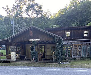
Chavies is a residential hamlet with a U.S. Post Office located in Perry County, Kentucky, United States.
Fishtrap was an unincorporated community located in Pike County, Kentucky, United States. Their Post Office has been closed. The community was flooded during the creation of Fishtrap Lake.

Oddville is an unincorporated community in Harrison County, Kentucky, United States. Oddville is located on U.S. Route 62, 5.4 miles (8.7 km) north-northeast of Cynthiana. The community was established in 1799; its name was chosen so that its post office would have a unique name. The aforementioned post office operated from 1851 to 1903.
Head of Grassy is an unincorporated community in Lewis County, Kentucky, United States. Head of Grassy is located on Kentucky Route 59 and the Grassy Fork 14.7 miles (23.7 km) south-southeast of Vanceburg; its name is a misnomer, as it lies 5 miles (8.0 km) downstream from the head of the Grassy Fork. Head of Grassy had a post office, which opened on November 19, 1878, and closed in 1982 or 1984.
Beefhide is an unincorporated community spanning across a county line between Letcher County and Pike County, Kentucky, United States.
Meta is an unincorporated community in Pike County, Kentucky. Meta is located at the junction of Kentucky Route 1426 and Kentucky Route 2169 7.7 miles (12.4 km) northeast of Pikeville. The community had a post office from 1896 to 1959.
Oven Fork is an unincorporated community in Letcher County, Kentucky. Oven Fork is located on U.S. Route 119 and the Cumberland River 4.2 miles (6.8 km) south of Whitesburg. Oven Fork had a post office from 1948 to 1993.
Buchanan, originally named Mouth of Bear, is an unincorporated community located in Lawrence County, Kentucky, United States at the mouth of Bear Creek where it joins the Big Sandy River, five miles downstream from the mouth of Blaine Creek.
Kirkville is a census-designated place and unincorporated community in Itawamba County, Mississippi, United States.
Saint Catharine is an unincorporated community in Washington County, Kentucky, United States. Its ZIP code is 40061.
Piso is an unincorporated community located in Pike County, Kentucky, United States. Their post office has been closed. The community was named by Bud Williamson after viewing an advertisement for medicine in an almanac.
Royrader is an unincorporated community in Jackson County, in the U.S. state of Kentucky. A post office called Royrader was established in 1927, and remained in operation until 1969. The community derives its name from Roy Rader, a businessperson in the local lumber industry. The community is along Kentucky Route 578 approximately 4 miles south of Annville, Kentucky, the county's largest community.
Lejunior is an unincorporated community in Harlan County, Kentucky, United States. The community is located along Kentucky Route 38 and the Cumberland River 4.3 miles (6.9 km) northeast of Evarts. Lejunior has a post office with ZIP code 40849.
Bradshaw is an unincorporated community located in central Jackson County, Kentucky, United States. The community is located on US Route 421 at its intersection with Kentucky Route 587, 3 miles east of McKee, the county seat.
New Zion is an unincorporated community located in northeastern Jackson County, Kentucky, United States. The community is located on Kentucky Route 587, 6 miles northeast of McKee and 3 miles south of Arvel. In the community is New Zion Ridge.
Clover Bottom is an unincorporated community located in northern Jackson County, Kentucky, United States. The community is located along US 421 at its intersection with Kentucky Route 1955. It is 3.4 miles northwest of Sandgap and 9.3 miles southeast of Berea. The community is addressed to McKee's ZIP code 40447, despite being past Sandgap, which has its own post office with ZIP code 40481, which partially serves the area around Clover Bottom.

Dango is a ghost town located in southwestern Jackson County, Kentucky, United States. The town was located at the confluence of Racoon Creek and Horse Lick Creek, which flows into the Rockcastle River. It is located southwest of McKee by 8 miles, and 2.7 miles southeast of another ghost town, Loam. Near the confluence of the two creeks is the historical Carpenter School, which may be named after Carpenter Ridge, of which it is two miles south of. Heavy settlement and farming occurred in the area around Horse Lick Creek, where Dango was, until the early 1900s. The area where Dango was is currently occupied by the Daniel Boone National Forest, known as the Horse Lick Creek Biopreserve, with the majority of ownership being private.
Loam is a ghost town located in southwestern Jackson County, Kentucky, United States. The town was located along Horse Lick Creek. It is located southwest of McKee by 7 miles, and 2.7 miles northwest of another ghost town, Dango. The town is located on Bethel Church Road according to the KYTC's State Primary Road System map for Jackson County. Heavy settlement and farming occurred in the area around Horse Lick Creek until the early 1900s. The area where Loam was is currently occupied by the Daniel Boone National Forest, in the Horse Lick Creek Biopreserve, with the majority of ownership being private.


