
Nicholas County is a county located in the U.S. state of Kentucky. As of the 2020 census, the population was 7,537. Its county seat is Carlisle, which is also the only incorporated community in the county. Founded in 1799, the county is named for Col. George Nicholas, the "Father of the Kentucky Constitution".

Jackson County is located in the Commonwealth of Kentucky. As of the 2021 census estimation, the population was 12,984. Its county seat is McKee. The county was formed in 1858 from land given by Madison, Estill, Owsley, Clay, Laurel, and Rockcastle counties. It was named for Andrew Jackson, seventh President of the United States. Jackson County became a moist county via a "local-option" referendum in the Fall of 2019 that made the sale of alcoholic beverages in the county seat, McKee, legal.
McKee is a home rule-class city located in the Commonwealth of Kentucky. It is the seat of Jackson County, KY. As of the 2020 census, the population of the city was 803. The city was founded on April 1, 1882 and was named for Judge George R. McKee. In 2019, the city held a vote regarding the sale of alcohol, which passed, making the city wet.
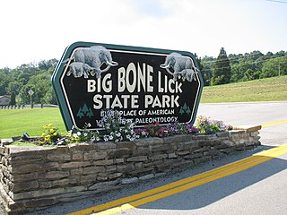
Big Bone Lick State Park is located at Big Bone in Boone County, Kentucky. The name of the park comes from the Pleistocene megafauna fossils found there. Mammoths are believed to have been drawn to this location by a salt lick deposited around the sulfur springs. Other animals including forms of bison, caribou, deer, elk, horse, mastodon, moose, musk ox, peccary, ground sloths, wolves, black bears, stag moose, saber-toothed cats, and possibly tapir also grazed the vegetation and salty earth around the springs that the animals relied on for their diet. One mastodon bone was unearthed here with a noticeable cut mark on it, implying that the Clovis people lived in the area thousands of years ago. The area near the springs was very soft and marshy causing many animals to become stuck with no way to escape. It bills itself as "the birthplace of American paleontology", a term which dates from the 1807 expedition by William Clark undertaken at the direction of President Thomas Jefferson. In Nicholas Cresswell's journal, dated 1774 to 1777, he records a visit in 1775 to what was then called "Elephant Bone Lick." In this account, Cresswell describes finding several bones of "prodigious size", as well as tusk fragments, and teeth—one weighing approximately 10 pounds. While he assumed the bones were from ancient elephants, the local native traditions claimed the bones to be those of white buffaloes that had been poisoned by the salty water.

Fort Boonesborough was a frontier fort in Kentucky, founded by Daniel Boone and his men following their crossing of the Kentucky River on April 1, 1775. The settlement they founded, known as Boonesborough, Kentucky, is Kentucky's second oldest European-American settlement. It served as a major frontier outpost during the American Revolutionary War, and survived into the early 19th century before its eventual abandonment. A National Historic Landmark now administered as part of Fort Boonesborough State Park, the site is one of the best-preserved archaeological sites of early westward expansion by British colonists in that period. It is located in Madison County, Kentucky off Kentucky Route 627.
Blue Licks Battlefield State Resort Park is a park located near Mount Olivet, Kentucky in Robertson and Nicholas counties. The park encompasses 148 acres (60 ha) and features a monument commemorating the August 19, 1782 Battle of Blue Licks. The battle was regarded as the final battle of the American Revolutionary War.
Wood Creek Lake is a 672-acre (2.72 km2) reservoir in Laurel County, Kentucky. Created by impounding Wood Creek in 1969, the lake is in the middle of Daniel Boone National Forest.

Kirklin Township is one of fourteen townships in Clinton County, Indiana. As of the 2010 census, its population was 1,380 and it contained 556 housing units.
Beaverlick is an unincorporated community in Boone County, Kentucky, United States. Beaverlick is located along U.S. Route 42 and U.S. Route 127 4.5 miles (7.2 km) west of Walton. The community was established as a fur trading site between 1780 and 1820. The community was founded sometime in the early 1800s. A post office was established at Beaver Lick in 1854 with John Tucker its postmaster. The post office closed in 1944.

Gray Hawk is a small, unincorporated community in eastern Jackson County, KY. The community is located along US Route 421. Services in the community include a post office, gas station, and restaurant. Gray Hawk has a community park and two waterfalls: McCammon Branch Falls and Flat Lick Falls.
Mud Lick is a rural unincorporated community in Monroe County, Kentucky, United States. It is concentrated around the intersection of Kentucky Route 63 and Kentucky Route 870, northwest of Tompkinsville.

Flippin is an unincorporated community located in Monroe County, Kentucky, United States. A small residential village and community surround the intersections of Kentucky Route 249, Kentucky Route 678, and Kentucky Route 100, approximately 3.6 miles (5.8 km) south of the Monroe-Barren County line. The south fork and main stream of Indian Creek, a tributary of the Big Barren River, merge at these crossroads in Flippin.
Perche Township is one of ten townships in Boone County, Missouri, USA. As of the 2012, its population was 4,037. The village of Harrisburg is the only incorporated settlement inside the township.
Millersburg is an unincorporated community in Callaway County, in the U.S. state of Missouri. It is located near the Boone-Callaway county line on the Owl Creek tributary of Cedar Creek. The Little Dixie Lake and Little Dixie Wildlife Management Area lie on Owl Creek just north of the community. It is on Missouri Route J about four miles south of I-70.
Glenville is an unincorporated community in McLean County, Kentucky, United States.
Sulphur Lick is a rural unincorporated community in northwestern Monroe County, Kentucky, United States. The community is located around the intersection of Kentucky Route 678 and Kentucky Route 839.
Arvel is an unincorporated community located near the tripoint border between Jackson, Lee, and Owsley Counties, Kentucky, United States. The community is located at the junction of Kentucky Route 587 and Kentucky Route 1209, 8 miles northeast of McKee and 13 miles southwest of Beattyville. A few locations in Arvel are also named Old Orchard, such as the Old Orchard Lookout Tower, which is 1/3 of a mile from Arvel and a historical school being the same distance from Arvel which may be evidence of the community also being called Old Orchard. A natural attraction in the area is Alcorn Branch Falls.
Clover Bottom is an unincorporated community located in northern Jackson County, Kentucky, United States. The community is located along US 421 at its intersection with Kentucky Route 1955. It is 3.4 miles northwest of Sandgap and 9.3 miles southeast of Berea. The community is addressed to McKee's ZIP code 40447, despite being past Sandgap, which has its own post office with ZIP code 40481, which partially serves the area around Clover Bottom.

Dango is a ghost town located in southwestern Jackson County, Kentucky, United States. The town was located at the confluence of Racoon Creek and Horse Lick Creek, which flows into the Rockcastle River. It is located southwest of McKee by 8 miles, and 2.7 miles southeast of another ghost town, Loam. Near the confluence of the two creeks is the historical Carpenter School, which may be named after Carpenter Ridge, of which it is two miles south of. Heavy settlement and farming occurred in the area around Horse Lick Creek, where Dango was, until the early 1900s. The area where Dango was is currently occupied by the Daniel Boone National Forest, known as the Horse Lick Creek Biopreserve, with the majority of ownership being private.
Beech Creek is a tributary of Goose Creek in Clay County in the U.S. state of Kentucky. It is just under 6 miles (9.7 km) long and joins the Goose approximately 1⁄2 mile (0.80 km) below the mouth of Laurel Creek.


