
Chillagoe-Mungana Caves is a national park in Chillagoe, Shire of Mareeba, Queensland, Australia.

Dimbulah is a rural town and locality in Far North Queensland, Australia, 114 kilometres (71 mi) from Cairns by road, on the Atherton Tableland. It is within the local government area of Shire of Mareeba. In the 2021 census, the locality of Dimbulah had a population of 975 people, a decrease from the 1,050 people in the 2016 census.

Chillagoe is a rural town and locality in the Shire of Mareeba, Queensland, Australia. In the 2021 census, the locality of Chillagoe had a population of 214 people.

Kuranda is a rural town and locality on the Atherton Tableland in the Shire of Mareeba, Queensland, Australia. It is 25 kilometres (16 mi) from Cairns, via the Kuranda Range road. It is surrounded by tropical rainforest and adjacent to the Wet Tropics of Queensland World Heritage listed Barron Gorge National Park. In the 2021 census, the locality of Kuranda had a population of 3,273 people.
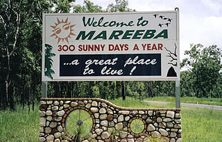
Mareeba is a rural town and locality in the Shire of Mareeba in Far North Queensland, Australia. Between 2008 and 2013, it was within the Tablelands Region. The town's name is derived from an Aboriginal word meaning meeting of the waters. In the 2021 census, the locality of Mareeba had a population of 11,825 people.
Mount Mulligan is a former mining town and now a rural locality in the Shire of Mareeba, Queensland, Australia. In the 2021 census, the locality of Mount Mulligan had "no people or a very low population".

Mutchilba is a rural town and locality in the Shire of Mareeba, in Far North Queensland, Australia. It is known for its production of mangoes.

Mount Molloy is a rural town and locality in the Shire of Mareeba, Queensland, Australia. It is a historic mining and timber town, 55 kilometres (34 mi) north of Cairns. The dominant industry in the area is cattle grazing; the town itself consists of a few shops and an old hotel. In the 2021 census, the locality of Mount Molloy had a population of 266 people.

The Shire of Mareeba is a local government area at the base of Cape York Peninsula in Far North Queensland, inland from Cairns. The shire, administered from the town of Mareeba, covered an area of 53,491 square kilometres (20,653.0 sq mi), and existed as a local government entity from 1879 until 2008, when it amalgamated with several councils in the Atherton Tableland area to become the Tablelands Region.
Irvinebank is a rural town and locality in the Shire of Mareeba, Queensland, Australia. In the 2021 census, the locality of Irvinebank had a population of 113 people.
Kajabbi is a rural town in the locality of Three Rivers, Shire of Cloncurry, Queensland, Australia.

Einasleigh is a town and a locality in the Shire of Etheridge, Queensland, Australia. In the 2021 census, the locality of Einasleigh had a population of 87 people.
Joskeleigh is a coastal rural locality in the Livingstone Shire, Queensland, Australia. In the 2021 census, the locality of Joskeleigh had a population of 60 people.

Watsonville is a rural town and locality in the Shire of Mareeba, Queensland, Australia. In the 2021 census, the locality of Watsonville had a population of 176 people.

Kingsborough is a small historic mining town in the locality of Thornborough in the Shire of Mareeba, Queensland, Australia. It was part of the Hodgkinson Minerals Area.

Thornborough is a rural town and locality in the Shire of Mareeba, Queensland, Australia. In the 2021 census, the locality of Thornborough had a population of 21 people.
Cardstone is a rural locality in the Cassowary Coast Region, Queensland, Australia. In the 2021 census, Cardstone had "no people or a very low population".

Lappa is a former railway town on the western side of the Atherton Tablelands near Petford in the Shire of Mareeba in Far North Queensland, Australia.

Mungana Archaeological Area is a heritage-listed former mining town at Mungana, Chillagoe, Shire of Mareeba, Queensland, Australia.It is also known as Mungana Prospect, Old Mungana Township, Mungana Township, Lady Jane Mine, Eclipse Limeworks and Cemetery, and Girofla Mine. It was added to the Queensland Heritage Register on 11 December 2008.

Almaden is a rural town and locality in the Shire of Mareeba, Queensland, Australia. In the 2021 census, the locality of Almaden had a population of 41 people.

