
Toxic waste is any unwanted material in all forms that can cause harm. Mostly generated by industry, consumer products like televisions, computers, and phones contain toxic chemicals that can pollute the air and contaminate soil and water. Disposing of such waste is a major public health issue.
Soil contamination, soil pollution, or land pollution as a part of land degradation is caused by the presence of xenobiotic (human-made) chemicals or other alteration in the natural soil environment. It is typically caused by industrial activity, agricultural chemicals or improper disposal of waste. The most common chemicals involved are petroleum hydrocarbons, polynuclear aromatic hydrocarbons, solvents, pesticides, lead, and other heavy metals. Contamination is correlated with the degree of industrialization and intensity of chemical substance. The concern over soil contamination stems primarily from health risks, from direct contact with the contaminated soil, vapour from the contaminants, or from secondary contamination of water supplies within and underlying the soil. Mapping of contaminated soil sites and the resulting clean ups are time-consuming and expensive tasks, and require expertise in geology, hydrology, chemistry, computer modelling, and GIS in Environmental Contamination, as well as an appreciation of the history of industrial chemistry.
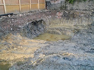
The Laurel Park, Inc. site, also known as Hunters Mountain Dump, or Murtha's Dump to locals, is a capped landfill that occupies approximately 20 acres (81,000 m2) of a 35-acre (140,000 m2) parcel of land in Naugatuck, Connecticut. The landfill has been in existence since the late 1940s, and several industries disposed of solvents, oils, hydrocarbons, chemical and liquid sludge, chemical solids, tires, and rubber products there. The facility continued to operate as a municipal landfill until 1987. It was owned and operated by Terrence and Howard Murtha.

Dorney Road Landfill is a 27-acre (11 ha) municipal and industrial landfill in Upper Macungie Township and Longswamp Township, Pennsylvania that was polluted with toxic waste from 1952 to 1978. The site is surrounded by rural residences and farmland. The U.S. Environmental Protection Agency (EPA) added the site to the Superfund National Priorities List in 1984. The site was remediated and removed from the National Priorities List in 2018.
The Lipari Landill is an inactive landfill on a 6-acre (2.4 ha) former gravel pit in Mantua Township, New Jersey. It was used from 1958 to 1971 as a dump site for household and industrial wastes. Toxic organic compounds and heavy metals dumped at the site have percolated into the ground water and leached into lakes and streams in the surrounding area. The site has been identified as the worst toxic dump in the United States and was ranked at the top of the United States Environmental Protection Agency's Superfund eligibility list.
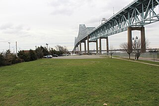
Wade Dump was a rubber recycling facility and illegal industrial waste storage and disposal facility in Chester, Pennsylvania. It was located at 1 Flower Street on the western bank of the Delaware River just north of the Commodore Barry Bridge.
The former Operating Industries Inc. Landfill is a Superfund site located in Monterey Park, California at 900 N Potrero Grande Drive. From 1948 to 1984, the landfill accepted 30 million tons of solid municipal waste and 300 million US gallons (1,100,000 m3) of liquid chemicals. Accumulating over time, the chemical waste polluted the air, leached into groundwater, and posed a fire hazard, spurring severely critical public health complaints. Recognizing OII Landfill's heavy pollution, EPA placed the financial responsibility of the dump's clean-up on the main waste-contributing companies, winning hundreds of millions of dollars in settlements for the protection of human health and the environment.
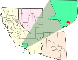
The Del Amo Superfund Site is located in southern Los Angeles County between the cities of Torrance and Carson. It is a U.S. EPA Region 9 Superfund Site. The waste-disposal site of a rubber manufacturer is one of 94 Superfund Sites in California as of November 29, 2010.
The United States Environmental Protection Agency added the PJP Landfill site in Marion Section of Jersey City, New Jersey to the Superfund National Priorities List on September 1, 1983, because hazardous chemicals were found in the soil and groundwater. The 87-acre site located in Hudson County contained a landfill that may have been used as early as 1968 to dispose of chemical and industrial wastes. In 1971 the State certified the landfill to receive solid wastes. Approximately 11,900 people currently reside within a one-mile radius of the site. The west side of the site is bordered by the Hackensack River which is used for boating and commercial shipping. Recently, AMB Corporation purchased a portion of the site.
The Oakdale Dump is an Environmental Protection Agency Superfund site located in Oakdale, Minnesota, and comprises three non-contiguous properties that were used for dumping from the late 1940s until the 1950s by the 3M corporation. The properties are named the Abresch, Brockman, and Eberle sites for their respective property owners at the time of disposal activities. The Abresch site is the largest of the three properties at about 55 acres. The Brockman site is located immediately southwest of the Abresch site and encompasses 5 acres. The Eberle site is located roughly 2,500 feet north of the Abresch site and encompasses 2 acres.

The Koppers Co., Inc. (KCI) Superfund Site is one of three Superfund sites in Oroville, California, along with Louisiana Pacific Sawmill and Western Pacific Railyard. The KCI Superfund Site is a 200-acre site which served as a wood treatment plant for 50 years. Wood was treated with many chemicals to prevent wood deterioration. The accumulation of these chemicals from spills, fires, and uses has caused this site to be contaminated with the hazardous waste material. Due to soil and groundwater contamination, the site was placed on the National Priorities List in 1984 for remedial action plans to clean up the site to protect surrounding residential areas concerning environmental and human health risks.
The Waste Disposal Inc. Superfund site is an oil-related contaminated site in the highly industrialized city of Santa Fe Springs in Los Angeles County, California. It is approximately 38 acres (15 ha), with St Paul's high school immediately adjacent to the northeast corner of the site. Approximately 15,000 residents of Santa Fe Springs obtain drinking water from wells within three miles (4.8 km) of the site.
The Nebraska Ordnance Plant is a former United States Army ammunition plant located approximately ½ mile south of Mead, Nebraska and 30 miles west of Omaha, Nebraska in Saunders County. It originally extended across 17,250 acres (69.8 km2) producing weapons from 1942-45 after which the Army used it as a bomb factory during the Vietnam War. Environmental investigations in the 1980's found the soil and groundwater contaminated with the explosive RDX and the degreaser trichloroethylene. In 1990, federal agencies added the site to the National Priorities List as a Superfund site. Remediation included soil excavation and water treatment, the latter of which has been ongoing since 1997. Water is contained and treated at 4 treatment plants and the known plumes are monitored at hundreds of wells. The latest wells, dug deeper into the bedrock than previously, showed RDX and TCE above desired action levels in April 2016.
Emmell's Septic Landfill (ESL) is located at 128 Zurich Ave, Galloway Township, New Jersey and takes up about 38 acres of space. The landfill was in operation from 1967 until 1979. ESL disposed of liquid and solid waste including many chemicals such as volatile organic compounds (VOCs), Polychlorinated Biphenyls (PCBs), Trichloroethene and Vinyl chloride which all had their own effect on the environment and community. These chemicals affected the groundwater required millions of dollars to reconstruct the groundwater pathways and provide clean water to residents. The landfill holds a Hazardous Ranking Score of a 50/100, qualifying for the Superfund National Priority List. In August 1999, the state acknowledged the site's contamination and held town meetings and provided research upon the site such as groundwater samples. In July 1997, a sitewide investigation was called upon by the United States Environmental Protection Agency. In total the clean up was estimated to cost $5 million to fund this superfund site, and a grant of $3.9 million was given by the Federal Government under the Recovery Act Funding (Previti). Today, the project is still ongoing however, greatly improved since the landfill was discovered.
Bog Creek Farm, located in Howell Township, New Jersey, is a designated Environmental Protection Agency (EPA) Superfund site. Lying on 12 acres of land, Bog Creek Farm is home to several hazardous and life-threatening contamination beginning in 1973 and continuing for a year. Over a decade later, actions began to take place to clean and restore the contaminated soil and water. Bog Creek Farm is situated near several other farms that house horses, growing crops and flowers, and livestock. Less than a mile down the road lies Allaire State Park, a park used by golfers, hunters, and fisherman.
The Horseshoe Road Complex Superfund Site in Sayreville, New Jersey is a 12-acre property located near the Raritan River. The industrial site has been out of operation since the early 1980s after a fire revealed 70 drums containing silver cyanide, ethyl acetate, and acetonitrile. The drums caught the attention of the Environmental Protection Agency (EPA) and by 1995 the Horseshoe Road Complex was on the National Priorities List. The site had three areas consisting of the Atlantic Development Corporation (ADC), Horseshoe Road Drum Dump, and Sayreville Pesticide Dump. The neighboring Atlantic Resources Corporation, the location for precious metal recovery, is addressed with the Horseshoe Road Complex (HRC) site due to the intermixing of chemical contamination. The on-site contamination is not an immediate threat to the surrounding community, although prolonged or repeated exposure to the site itself, will result in health effects. The HRC Superfund site is now in its final steps of cleanup in accordance to the EPA's plan.
Brook Industrial Park (BIP) is an industrial area occupying 4.5 acres of the Borough of Bound Brook, New Jersey, in the United States of America. It is located on the northern bank of the Raritan River. Industrial, chemical and pesticide operations began in 1971 and eventually lead to the contamination of groundwater and exposure of workers to harmful dioxins. Throughout 1980 to 1988 the United States Environmental Protection Agency (EPA) and the New Jersey Department of Environmental Protection (NJDEP) conducted studies to determine if there were any threats being posed on the workers, community or environment by the BIP companies in their disposal of processed and stored chemicals.
Price Landfill is a 26-acre site located in Pleasantville, Egg Harbor Township, Atlantic County, New Jersey. Price Landfill is also known as Price Sanitary Landfill, Prices Pit, Price Landfill No.1 and Price Chemical Dump. The United States Environmental Protection Agency (USEPA) added Price Landfill to the Superfund National Priorities List on September 20, 1983, because of the hazardous chemicals found on the site and in the groundwater. The site was originally owned by Mr. Charles Price and was used to mine sand and gravel, which was shut down in 1968. The site was then turned into a private landfill in 1969 and then a commercial solid waste landfill in 1971. At this point the landfill was used to dispose of liquid waste by companies, specifically Atlantic City Electric Company. The liquid waste consisted of industrial chemicals, oils and greases/sludges, septic tank and sewer wastes, which were disposed on the site for 8 years, ending altogether in 1976, but in the meantime, having contaminated the groundwater, soil, air, and nearby creeks, specifically Absecon Creek. Chemicals dumped on the site are believed to be 1,2-Dichloroethane, arsenic, benzene, chloroform, lead, and vinyl chloride, all of which contaminated the groundwater, soil, air, and nearby creeks. The USEPA originally got involved in 1982 by beginning to correct the damage. Currently the USEPA states that they are continuing to monitor and treat the groundwater and land, and that hazards to humans are controlled.
The Burnt Fly Bog Superfund Site is located in Marlboro Township in Monmouth County, New Jersey. Contamination began in the 1950s and 1960s. It was used as a dumping ground for hazardous chemicals and oils. This site was used to reprocess or recycle oil, and it was also used as a landfill during the 1950s. The contamination affected the surface water and soil. The EPA got involved in the 1980s and addressed the situation. Human health concerns were a main part of the EPA getting involved because residents lived only about 1,000 to 2,000 feet around the site. Major components of the remedy included excavation and off-site disposal of contaminated soil from Northerly Wetlands, Tar Patch Area. The back filling of the areas addressed, monitoring of the surface water and sediments, and biological sampling in the Westerly Wetlands. The current status of the site is complete. The remedial stages were completed in the late 1990s and a five-year monitoring of the surface water was completed around 2004.
Forest Waste Products is a 120-acre (49-hectare) Superfund site in Forest Township northwest of Otisville, Michigan.

