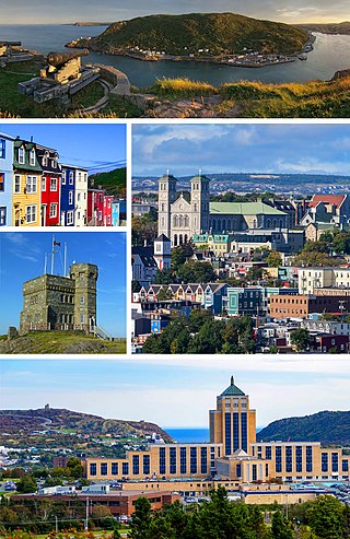
St. John's is the capital and largest city of the Canadian province of Newfoundland and Labrador. It is located on the eastern tip of the Avalon Peninsula on the island of Newfoundland.

Cape Spear is a headland located on the Avalon Peninsula of Newfoundland near St. John's in the Canadian province of Newfoundland and Labrador. At a longitude of 52°37' W, it is the easternmost point in Canada and North America, excluding Greenland.
The Main Street District of downtown Dallas, Texas runs along Main Street and is bounded by Elm Street one block north, Commerce St. one block south, N. Lamar St. to the west, and US 75/I-45 (I-345) elevated highway to the east. The district is the spine of downtown Dallas, and connects many of the adjoining business and entertainment districts. It does not include Dealey Plaza or the John Fitzgerald Kennedy Memorial which are a few blocks west in the West End Historic District.

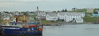
Battle Harbour is a summer fishing station, formerly a permanent settlement, located on the Labrador coast in the province of Newfoundland and Labrador, Canada. Battle Harbour was for two centuries the economic and social centre of the southeastern Labrador coast. Mercantile saltfish premises first established there in the 1770s developed into a thriving community that was known as the Capital of Labrador. It fell into decline following reductions in the cod fishery and a major fire in 1930, and was abandoned as a permanent settlement following government resettlement activity in the 1960s.

Water Street is located in downtown St. John's, Newfoundland and Labrador, Canada. It became a commercial trading outpost for the Basques, French, Spanish, Portuguese, and English. The street now boasts many souvenir shops, restaurants, pubs, and high-end boutiques, as well as other commercial ventures. To this day the street remains the hub of commercial activity in the city and in 2020 the city implemented a seasonal pedestrian-only section of the road.

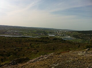
Quidi Vidi is a neighbourhood in St. John's, Newfoundland and Labrador. The village is adjacent to Quidi Vidi Lake. Quidi Vidi's harbour is known as "The Gut". Located in Quidi Vidi is the Quidi Vidi Battery Provincial Historic Site. The village is home to several small businesses.
Goulds is a designated place in the Canadian province of Newfoundland and Labrador. It is a rural neighbourhood within the City of St. John's southeast of the city centre.

Rawlins Cross, formed by the intersection of Prescott and Flavin Streets, Monkstown, Rennies Mill, Queens, and Military Roads, is a well known St. John's, Newfoundland and Labrador landmark. Military Road, built in 1773, was one of the first roads in this area that joined Fort William with Fort Townsend. Monkstown Road was built in the early 19th century and Prescott Street around 1840. It is on the edge of Monkstown, which is part of the Georgetown Improvement Area and Downtown St. John's.

Stephen Avenue is a major pedestrian mall in downtown Calgary, Alberta, Canada. The mall is the portion of 8 Avenue SW between 4 Street SW and 1 Street SE. It is open to vehicles only from 6:00 p.m. to 6:00 a.m.

John Street is a street in Downtown Toronto. It runs from Stephanie Street and Grange Park in the north to the Metro Toronto Convention Centre on Front Street in the south. It is home to a number of Toronto's cultural institutions, including buildings for the CBC, CTV, Toronto International Film Festival. The National Post has described it as "Running directly through the entertainment district, its spine connects many great cultural institutions, popular retail outlets, restaurants and soon-to-be-built condos." The City of Toronto has dubbed the street a "Cultural Corridor" and a report calls it "the centrepiece of the Entertainment District."

Pippy Park is a 3,400-acre (14 km2) urban park located in the city of St. John's, Newfoundland. It is the second largest provincially-managed urban park in Canada, after Fish Creek Provincial Park in Calgary, Alberta. The park is a popular camping, hiking and recreational park within the city, and incorporates numerous groomed and wilderness-style hiking/skiing trails, a miniature golf course, a 9-hole and an 18-hole golf course, a driving range, and a public access trailer park with limited tent camping facilities. Trails within the park link to the Grand Concourse walking trails.

The LSPU Hall is a large wooden structure in St. John's, Newfoundland and Labrador. Located on 3 Victoria Street, it is currently the home of the Resource Centre for the Arts (RCA). The name comes from a previous owner, the Longshoremen's Protective Union. The Hall is a registered heritage building.
The neighbourhood of Pleasantville in St. John's, Newfoundland and Labrador is located in the east end of the city, directly north of the downtown. The neighbourhood extends from the north side of Quidi Vidi Lake northward to Newfoundland Drive, and is largely made up of apartment blocks.
The architecture of St. John's, in Newfoundland and Labrador, Canada, has a style distinct from that of the rest of Canada, and its major buildings are remnants of its history and prestige as the first British colonial capital. The city of St. John's has had a long history, with inhabitation dating to the 16th century onwards. As the city grew, so, too, did the landscape. Buildings took a variety of styles according to the styles and means available to build the structures. Starting as a fishing outpost for European fishermen, St. John's consisted mostly of the homes of fishermen, sheds, storage shacks, and wharves. Of course, these structures were small and constructed out of wood. Like many other cities of the time, as the Industrial Revolution took hold and new methods and materials for construction were introduced, the landscape changed as the city grew in width and height. The Great Fire of 1892 destroyed most of the downtown core, and most residential and other wood-frame buildings date from this period. Often compared to San Francisco because of its hilly terrain and steep maze of residential streets, housing in St. John's is typically painted in bright colours, unlike most other parts of Canada.

The St. John’s Court House is located on Water Street and Duckworth Street in St. John’s, Newfoundland and Labrador. Constructed in 1901–04, the building is a National Historic Site of Canada. Sources differ with regard to its architect; it was designed either by William Tuff Whiteway or by William H. Greene.

The Jasper Park Information Centre National Historic Site, located in Jasper National Park, Alberta, Canada, is the primary visitor contact centre for visitors to the park. Sited in the Jasper townsite, it was built as the park administration building in 1913-1914, and became the visitor contact centre in 1972. It is located in Athabasca Park, which is not included in the National Historic Site designation.
The Ryan Premises is a National Historic Site of Canada located in the town of Bonavista, Newfoundland and Labrador. It is preserved as an example of a large-scale merchant operation in a Newfoundland outport.
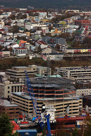
351 is a 165,000-square-foot office building. The high-rise is in downtown St. John's, Newfoundland and Labrador, at 351 Water Street. The office building is the first to be constructed downtown in 25 years and was completed in 2013 by East Port Properties.

Division No. 1, Subdivision G is an unorganized subdivision on the Avalon Peninsula in Newfoundland and Labrador, Canada. It is in Division 1 and contains the unincorporated communities of Baccalieu Island, Besom Cove, Bradley's Cove, Burnt Point, Caplin Cove, Daniel's Cove, Grates Cove, Gull Island, Job's Cove, Kingston, Long Beach, Lower Island Cove, Low Point, Northern Bay, Ochre Pit Cove, Red Head Cove, Riverhead, Smooth Cove and Western Bay.
