
Kaski District, a part of Gandaki Province, is one of the seventy-seven districts of Nepal. The name is disambiguated from Kaskikot, the ancient Kaski Kingdom.
Sarlahi, a part of Madhesh Province, is one of the seventy-seven districts of Nepal. According to new laws, a combination of more than two or four villages makes a municipality, which covers an area of 1,259 km2 (486 sq mi) and had a population of 635,701 in 2001 and 769,729 in 2011.

ChurjhariRukumk is a town in a valley of the Eastern Rukum District in Nepal. Nearby is a pond called Rukmini Tal. There is an historic Shibalaya temple nearby. Other temples include the Barah, Baraji, and Bhagwati temples.
Daraune Pokhari is a village development committee in Kabhrepalanchok District in Bagmati Province of central Nepal. At the time of the 1991 Nepal census it had a population of 3,138 and had 575 houses in it.
Pokhari Chauri is a village development committee in Kavrepalanchok District in the Bagmati Zone of central Nepal. At the time of the 1991 Nepal census it had a population of 3,879 in 609 individual households. It lies in the border of Ramechhap and kavrepalanchowk district. It is about 80 km away from the capital of Nepal, Kathmandu
Pokhari Narayansthan is a village development committee in Kabhrepalanchok District in the Bagmati Zone of central Nepal. At the time of the 1991 Nepal census it had a population of 3,106 in 535 individual households.
Myal Pokhari is a village and municipality in Gulmi District in the Lumbini Zone of central Nepal. At the time of the 1991 Nepal census it had a population of 2282.
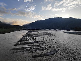
Bharat Pokhari is a town in Kaski District in the Gandaki Province of northern-central Nepal. It lies at the height of 657 to 1600 meters above sea level. At the time of the 1991 Nepal census it had a population of 8,889 persons living in 1782 individual households. Bharat Pokhari was a Village Development Committee, and it is merged with Lekhnath Municipality.
Shankar Pokhari is a village development committee in Parbat District in the Dhawalagiri Zone of central Nepal. At the time of the 1991 Nepal census it had a population of 2547 people living in 830 individual households.
Balara (Maithili/Nepali: बलरा) is a municipality in Sarlahi District, a part of Madhesh Province in Nepal. It was formed in 2016 occupying current 12 sections (wards) from previous 9 former VDCs. It occupies an area of 48.55 km2 with a total population of 45,194.
Bhadsar is a village development committee in Sarlahi District in the Janakpur Zone of south-eastern Nepal. At the time of the 1991 Nepal census it had a population of 2,950 people living in 499 individual households.
Gamhariya is a Village Development Committee in Sarlahi District in the Janakpur Zone of south-eastern Nepal. At the time of the 2011 Nepal census it had a population of 8,000 people residing in 674 individual households. It has two sub villages small Palsi which is hardly 1 km east of the village and other is called Ganesiya which is located at south of the village which is also 1 km. North Ganesiya is associate with Gamhariya identified by ward no 6 and south part is located in Musaili VDC.
Hariwan Municipality is one of the new municipalities declared by the Government of Nepal on May 18, 2014. It is located in Sarlahi District Janakpur zone, Nepal. It is formed by the joining of four contemporary Village development committees (VDCs) namely Atrouli, Sasapur, Ghurkauli and Harion VDCs covering an area of 88.1 km2. It has been divided into 11 wards with an administration center in Harion Bazar. According to Nepal Population Census 2011, the municipality has a total population of 42,783.
Jamuniya is a village development committee in Sarlahi District in the Janakpur Zone of south-eastern Nepal. At the time of the 1991 Nepal census it had a population of 5,399 people living in 914 individual households.
Kabilasi is a Municipality in Sarlahi District in the Janakpur Zone of south-eastern Nepal. At the time of the 1991 Nepal census it had a population of 7,050 people residing in 1,362 individual households.
Parsa is a rural municipality in Sarlahi District, a part of Province No. 2 in Nepal. It is situated 10 km East from Malangwa which is headquarter of Sarlahi. It was formed in 2016 occupying current 6 sections (wards) from previous 6 former VDCs. It occupies an area of 23.12 km2 with a total population of 21,650. The major language spoken in the rural municipality are Maithili and Bajjika.
Sisaut is a Rural Municipalities in Sarlahi District in the Madhesh Province of south-eastern Nepal. At the time of the 2011 Nepal census, it had a population of 7,967 people living in 1,283 individual households. It is about 34km away from Mahendra Highway. It lies 208 km south east of the capital Kathmandu. Durga-puja during the Dashain festival is very famous here, many devotees from various villages come to here in the evening.[Sandhya Aarti]. It lies around 18 kilometers west of the district headquarters Malangwa. People form here are kind hearted and self-motivated. It has a high literate rate as compare to other districts of Madhesh Province. The number of civil workers[Government Job Holders] is high.
Developmental works are being done by the representatives of here like MP, Mayor and Wada Chairman. The Present MP of this region[Sarlahi Area no.4] is Dr. Amresh Kumar Singh. The Present Mayor of this Region[Ramnagar rural municipality] is Raja Babu Yadav.[Youngest Mayor of Nepal].
Badagaun is a village development committee in Salyan District in Karnali Province of western-central Nepal. At the time of the 1991 Nepal census it had a population of 3283 people living in 385 individual households.
Bhuwan Pokhari is a village development committee in Palpa District in the Lumbini Zone of southern Nepal. At the time of the 1991 Nepal census it had a population of 5113 people living in 969 individual households.

