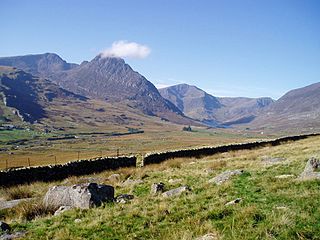
The Cambrian Mountains are a series of mountain ranges in Wales. The term Cambrian Mountains used to apply to most of the upland of Wales, and comes from the country's Latin name Cambria. Since the 1950s, its application has become increasingly localised to the geographically homogeneous Mid Wales uplands, known in Welsh as Elenydd, which extend from Plynlimon (Pumlumon) to Radnor Forest in the east and Mynydd Mallaen to the south. This barren and sparsely populated 'wilderness' has been referred to as the Desert of Wales. The area includes the sources of the River Severn and River Wye and was unsuccessfully proposed as a national park in the 1960s and 1970s. The highest point of the range is Plynlimon, at 2,467 feet (752 m).

Ogof Craig a Ffynnon is a cave in Wales. The cave is about 7 km in length and is located at the base of a quarried rockface in the Clydach Gorge. Water flowing out of the cave is a resurgence of water draining off Llangatock Mountain above.

The Glyderau are a mountain group in Snowdonia, North Wales. The name derives from the highest peaks in the range, Glyder Fawr and Glyder Fach. According to Sir Ifor Williams, the word "Glyder" derives from the Welsh word "Cludair", meaning a heap of stones.

Moel Hebog is a mountain in Snowdonia, north Wales which dominates the view west from the village of Beddgelert. It gives name to a whole range of peaks in the north-western corner of Snowdonia, which include the Nantlle Ridge and Mynydd Mawr.

The Black Mountain is a mountain range in South, Mid and West Wales, straddling the administrative boundary between Carmarthenshire and Powys and forming the westernmost range of the Brecon Beacons National Park. Its highest point is Fan Brycheiniog at 802 metres or 2,631 ft. The Black Mountain also forms a part of the Fforest Fawr Geopark.

The Beacons Way is a waymarked long distance footpath in the Brecon Beacons National Park, Wales. It is a linear route which runs for 99 miles (159 km) east to west through the National Park, and passes many of the most important landmarks and mountain peaks in the mountain range. It also includes a few of the towns in the park as well as popular attractions such as Carreg Cennen Castle near Llandeilo at the western end of the path.
Fforest Fawr Geopark is a Geopark in the Brecon Beacons National Park, south Wales. It is the first designated Geopark in Wales having gained membership of both the European Geoparks Network and the UNESCO-assisted Global Network of National Geoparks in October 2005. The Geopark aims to promote and support sustainable tourism and other opportunities to improve the economy of the area whilst safeguarding the natural environment. Its aims largely coincide with the statutory duties and purpose of the National Park within which it sits.

The Grwyne Fawr is a river in the Brecon Beacons National Park in south Wales. A section of it forms the administrative border between Powys and Monmouthshire and also of the historic counties of Brecon and Monmouth. The river and its major tributary the Grwyne Fechan flow into the River Usk at Glangrwyney.

Mynydd Llangatwg or Llangattock Mountain is a hill in the Brecon Beacons National Park in the county of Powys, south Wales. It is named from the village of Llangatwg which sits in the valley of the River Usk to the north of it. It is essentially an undulating plateau rising in the west to a height of 530 metres (1,740 ft) at grid reference SO171157 and in the east to a height of 529 metres (1,736 ft) at Hen Dy-aderyn / Twr Pen-cyrn. This spot is marked by a trig point. The shallow pool of Pwll Gwy-rhoc sits in a broad depression towards the northern edge of the plateau whilst a smaller pool frequently occupies a large shakehole a few hundred metres to its west. The hill forms an impressive northern scarp overlooking the Usk valley and commonly referred to as the Llangattock Escarpment. Its southern margins are more subdued. Its eastern end is defined by the drops into the Clydach Gorge. Beyond the B4560 to the west the hill merges with Mynydd Llangynidr which has a similar character.

Trefil is a small village in the county borough of Blaenau Gwent, south Wales. It lies at the top of the Sirhowy Valley, near to Brecon Beacons National Park. It is three miles northwest of Tredegar. With one public house, The Top House, serving homemade food and drinks to local visitors.

Mynydd-y-glog is a hill just east of the village of Penderyn in the northern corner of the county borough of Rhondda Cynon Taff in south Wales. It lies within the Brecon Beacons National Park and Fforest Fawr Geopark. Its summit plateau rises to a height of 389m / 1277 ft at OS grid ref SN 982088, a spot marked by a trig point. To its north lies the partly dry valley of Pant Sychbant which forms the eastern extension of Cwm Cadlan. Its southern slopes are drained by various streams which feed into the Afon Cynon.
Penmoelallt or Onllwyn is a hill in the northern part of the county borough of Rhondda Cynon Taff in south Wales. It lies within the Brecon Beacons National Park and Fforest Fawr Geopark. To its east lies the deep valley of Cwm Taf and to its north a rather shallower valley in which the Nant Cadlan originates. To the west is the hill known as Mynydd-y-glog and to the south are slopes draining into the River Taff and the Afon Cynon. The hill culminates in a broken plateau with several knolls rising above the 420m contour. Its afforested nature makes it difficult to determine the precise location of its highest point but this probably lies somewhere around OS grid ref SO 003096. Older maps indicate a spot height of 1376 ft above sea level at SO 000090.
The geology of Monmouthshire in southeast Wales largely consists of a thick series of sedimentary rocks of different types originating in the Silurian, Devonian, Carboniferous, Triassic and Jurassic periods.
Chartist Cave is a culturally significant cave on Mynydd Llangynidr in southern Powys, Wales. The entrance is a broad arch formed of Twrch Sandstone which overlies the Carboniferous Limestone immediately beneath.

Mynydd y Lan is a 381-metre-high flat-topped hill in Caerphilly county borough in South Wales. It falls largely within the community of Ynysddu but its northern and eastern margins are within Crosskeys community. Its largely wooded southern and eastern flanks rise steeply from the Sirhowy and Ebbw valleys respectively. A wireless transmission station is located towards the northern end of the summit plateau. The current name is a possible corruption of Mynydd y Llan, referencing the parish church of St Tudor, situated on its plateau. the church site has been occupied since the 5th century, with an early British site, being replaced by the Norman 11th century church.
This article describes the geology of the Brecon Beacons National Park in mid/south Wales. The area gained national park status in 1957 with the designated area of 1,344 km2 (519 sq mi) including mountain massifs to both the east and west of the Brecon Beacons proper. The geology of the national park consists of a thick succession of sedimentary rocks laid down from the late Ordovician through the Silurian and Devonian to the late Carboniferous period. The rock sequence most closely associated with the park is the Old Red Sandstone from which most of its mountains are formed. The older parts of the succession, in the northwest, were folded and faulted during the Caledonian orogeny. Further faulting and folding, particularly in the south of the park is associated with the Variscan orogeny.
Mynydd Garnclochdy is a gentle summit on the long moorland ridge which extends south from the Blorenge towards Pontypool and which defines the boundary between the modern county of Monmouthshire to the east and the county borough of Torfaen to the west though historically it was entirely within the traditional county of Monmouthshire. Its summit, at a height of 448 m (1407 ft), is marked by a small cairn. The summit and the eastern slopes of the hill fall within the Brecon Beacons National Park. A southern top of the hill, Mynydd Garn-wen achieves a height of 436m, and carries a trig point further south again at an elevation of 425m. To the north the broad moorland ridge runs via a poorly defined 425m top and a col at 404m elevation just south of a minor east–west road, into Mynydd y Garn-fawr, east of Blaenavon.
The bedrock geology of Carmarthenshire in west Wales consists largely of Palaeozoic age sedimentary rocks. Unconsolidated deposits of Quaternary age in Carmarthenshire include a dissected cover of glacial till, valley floor alluvium and some scattered peat deposits in both upland and lowland settings. There are extensive beach and tidal flat deposits along the Carmarthenshire coast. The exploitation of the county's mineral riches, particularly coal and limestone, was a key part of the local economy through much of the nineteenth and twentieth centuries.


