
Powys is a county and preserved county in Wales. It is named after the Kingdom of Powys which was a Welsh successor state, petty kingdom and principality that emerged during the Middle Ages following the end of Roman rule in Britain.
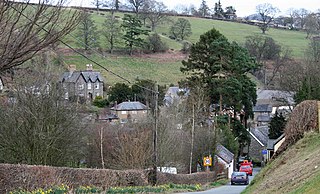
Llanrhaeadr-ym-Mochnant is a village, community and an ecclesiastical parish in the extreme north of Powys, Wales; about 9 miles west of Oswestry and 12 miles south of Llangollen, on the B4580. It lies near the foothills of the Berwyn mountains on the river Rhaeadr. At the top end of the valley is the Pistyll Rhaeadr waterfall, one of the Seven Wonders of Wales in the old rhyme. One mile north of the town is the hill Moel Hen-fache. The community includes the hamlet of Llanarmon Mynydd Mawr.

The Brecon Beacons National Park is one of three national parks in Wales, and is centred on the Brecon Beacons range of hills in southern Wales. It includes the Black Mountain in the west, Fforest Fawr and the Brecon Beacons in the centre and the Black Mountains in the east.

TryfanWelsh pronunciation: [ˈtrəvan]) is a mountain in the Ogwen Valley, Snowdonia, Wales. It forms part of the Glyderau group, and is one of the most recognisable peaks in Britain, having a classic pointed shape with rugged crags. At 917.5 metres above sea level, it is the fifteenth-highest mountain in Wales. Tryfan was voted Britain's favourite mountain by Trail magazine.

The Englishman who Went up a Hill but Came down a Mountain is a 1995 film with a story by Ifor David Monger and Ivor Monger, written and directed by Christopher Monger. It was entered into the 19th Moscow International Film Festival and was screened in the Un Certain Regard section at the 1995 Cannes Film Festival.

The Black Mountains are a group of hills spread across parts of Powys and Monmouthshire in southeast Wales, and extending across the England–Wales border into Herefordshire. They are the easternmost of the four ranges of hills that comprise the Brecon Beacons National Park, and are frequently confused with the westernmost, which is known as the Black Mountain. The Black Mountains may be roughly defined as those hills contained within a triangle defined by the towns of Abergavenny in the southeast, Hay-on-Wye in the north and the village of Llangors in the west. Other gateway towns to the Black Mountains include Talgarth and Crickhowell. The range of hills is well known to walkers and ramblers for the ease of access and views from the many ridge trails, such as that on the Black Hill (Herefordshire) at the eastern edge of the massif.

Sugar Loaf, sometimes called The Sugar Loaf, is a hill situated 2 miles (3.2 km) north-west of Abergavenny in Monmouthshire, Wales and sits within the Brecon Beacons National Park. It is the southernmost of the summit peaks of the Black Mountains, with a height of 1,955 feet (596 metres). Sugar Loaf was gifted to the National Trust by suffragette Lady Rhondda.

Blorenge, also called The Blorenge, is a prominent hill overlooking the valley of the River Usk near Abergavenny, Monmouthshire, southeast Wales. It is situated in the southeastern corner of the Brecon Beacons National Park. The summit plateau reaches a height of 1,841 feet (561 m).
Taff's Well, is a semi-rural village, community and electoral ward located at the south easterly tip of Rhondda Cynon Taf, 6 miles (9.7 km) to the North of Cardiff, the capital city of Wales. Known locally as the 'Gates to the Valleys', it is separated from Gwaelod Y Garth by the River Taff. Taff's Well is distinguished because it contains the only thermal spring in Wales. The tepid water is thought to rise along a fault-line from the Carboniferous Limestone, in somewhat similar manner to the warm springs at Bristol and Bath. Various religious groups regard it as a spiritual site.

The River Rhondda is a river in South Wales with two major tributaries, Rhondda Fawr and Rhondda Fach.

Llansilin is a village and local government community in Montgomeryshire, Powys, Wales, 5 miles (8 km) west of Oswestry. The community, which includes Llansilin village, a large rural area and the hamlets of Moelfre and Rhiwlas as well as the remote parish of Llangadwaladr, had a population of 648 at the 2001 census, increasing to 698 at the 2011 Census. There is also an electoral ward including the nearby village of Llanrhaeadr-ym-Mochnant with a population of 2,295.

Garth Hill is a hill located in between the communities of Llantwit Fardre and Pentyrch in Wales. The Garth can be seen from nearly the whole of the city of Cardiff and the Taff Valley, and on a sunny, clear day as far as Weston-super-Mare across the Bristol Channel in southwest England. It lies adjacent to the Taff Vale with the village of Pentyrch on one side and looks down onto the small villages of Gwaelod-y-Garth and Taff's Well. The Garth has a number of tumuli on its top. These are burial sites dating from the early to middle Bronze Age.
Christopher Monger is a Welsh screenwriter, director and editor, best known for writing and directing The Englishman who Went up a Hill but Came down a Mountain and writing the HBO biopic Temple Grandin. He has directed eight feature films and written over thirty screenplays.

Llangelynnin is a former parish in the Conwy valley, in Conwy county borough, north Wales. Today the name exists only in connection with the church, a school in the nearby village of Henryd, and the nearby mountain ridge, Craig Celynnin.

Pantydraco was a genus of basal sauropodomorph dinosaur from the Late Triassic of the United Kingdom (Wales). It is based on a partial juvenile skeleton once thought to belong to Thecodontosaurus. Only one valid species of Pantydraco is recognised: P. caducus.

The Beacons Way is a waymarked long distance footpath in the Brecon Beacons National Park, Wales. It is a linear route which runs for 99 miles (159 km) east to west through the National Park, and passes many of the most important landmarks and mountain peaks in the mountain range. It also includes a few of the towns in the park as well as popular attractions such as Carreg Cennen Castle near Llandeilo at the western end of the path.

Mynydd Llangorse is a hill on the western edge of the Black Mountains in the Brecon Beacons National Park in Powys, south Wales. It lies two miles east of Llangors and its lake and 5 miles south of Talgarth. Its summit at 515m overtops the location 600m to the south at which a trig point is sited by 9m. The broad spur of Cefn Moel extends south towards the village of Bwlch whilst a spur to the southeast forms Pen Tir which reaches just over 450m above sea level. It is a Marilyn with a prominence of 161 metres.

Hay Bluff is a prominent hill at the northern tip of the Black Mountains, an extensive upland massif which straddles the border between south-east Wales and England. The mountain sits at the point where the main northeast-facing escarpment of the Black Mountains meets the northwest facing escarpment, the next peak to the west being Twmpa. The flat summit of Hay Bluff which is marked by a triangulation pillar at a height of 677 metres (2,221 ft) overlooks the middle Wye Valley and the book town of Hay-on-Wye.
The 19th Moscow International Film Festival was held from 17 to 28 July 1995. The Golden St. George was not awarded.
