Myrtle Springs, Texas

Last updated

Myrtle Springs, Texas
CDP
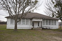
Myrtle Springs School Wiki.jpg
Old Myrtle Springs School
Coordinates: 32°37′24″N95°55′48″W / 32.62333°N 95.93000°W / 32.62333; -95.93000
Country United States
State Texas
County Van Zandt
Area
  Total7.4 sq mi (19.2 km2)
  Land7.3 sq mi (18.9 km2)
  Water0.1 sq mi (0.3 km2)
Elevation
[1]
522 ft (159 m)
Population
 (2010)
  Total828
  Density110/sq mi (43/km2)
Time zone UTC-6 (Central (CST))
  Summer (DST) UTC-5 (CDT)
Zip Code
75169
GNIS feature ID2586962 [1]

Myrtle Springs is a census-designated place (CDP) in Van Zandt County, Texas, United States. It was a new CDP for the 2010 census with a population of 828. [2]

Contents

Geography

Myrtle Springs has a total area of 7.4 square miles (19 km2), of which 7.3 square miles (19 km2) are land and 0.1 square miles (0.26 km2) are water. [3]

Demographics

Historical population
CensusPop.Note
2010 828
U.S. Decennial Census [4]
1850–1900 [5] 1910 [6]
1920 [7] 1930 [8] 1940 [9]
1950 [10] 1960 [11] 1970 [12]
1980 [13] 1990 [14] 2000 [15]
2010 [16]

Myrtle Springs first appeared as a census designated place in the 2010 U.S. Census. [16]

Related Research Articles

<span class="mw-page-title-main">Spring Garden-Terra Verde, Texas</span> Former CDP in Texas, United States

Spring Garden-Terra Verde is a census-designated place (CDP) in Nueces County, Texas, United States. The population was 693 at the 2000 census.

<span class="mw-page-title-main">Windemere, Texas</span> Former CDP in Texas, United States

Windermere is a former census-designated place (CDP) in Travis County, Texas, United States. The population was 1,037 at the 2010 census. It has since largely been annexed by the city of Pflugerville.

<span class="mw-page-title-main">Botines, Texas</span> Census-designated place in Webb County, Texas

Botines is a census-designated place (CDP) in Webb County, Texas, United States. The population was 149 at the 2020 census. Botines is located 5 miles (8.0 km) north of Laredo. The town's name originates from the Spanish term botín, which means buskin, boot, or legging.

Laredo Ranchettes is a census-designated place (CDP) in Webb County, Texas, United States. The population was 22 at the 2010 census.

<span class="mw-page-title-main">Oilton, Texas</span> Census-designated place in Webb County, Texas, United States

Oilton is a census-designated place (CDP) in Webb County, Texas, United States. The population was 152 at the 2010 census. The community is within the boundary of Webb Consolidated Independent School District and is home to the Oilton Elementary School.

Ranchitos Las Lomas is a census-designated place (CDP) in Webb County, Texas, United States. The population was 167 at the 2020 census. Las Lomas means "the hills" in Spanish.

<span class="mw-page-title-main">Ranchos Penitas West, Texas</span> CDP in Texas, United States

Ranchos Penitas West is a census-designated place (CDP) in Webb County, Texas, United States. The population was 466 at the 2020 census.

Boling is a census-designated place (CDP) in Wharton County, Texas, United States. This was a new CDP formed from parts of the Boling-Iago CDP prior to the 2010 census with a population of 1122.

Abram is an unincorporated community and census-designated place in Hidalgo County, Texas, United States. Its population was 2,067 as of the 2010 census. The community was named after Texas Ranger Abram Dillard, who was a resident of the area.

Arroyo Gardens is a census-designated place (CDP) in Cameron County, in the U.S. state of Texas. The population was 456 at the 2010 census. Prior to the 2010 census, the community was part of the Arroyo Gardens-La Tina Ranch CDP. It is part of the Brownsville–Harlingen Metropolitan Statistical Area.

Shadybrook is a census-designated place (CDP) in Cherokee County, Texas, United States. The population was 1,967 at the 2010 census.

Pleasant Hill is a census-designated place (CDP) in Polk County, Texas, United States. This was a new CDP for the 2010 census, with a population of 522.

Indian Springs is a census-designated place (CDP) in Polk County, Texas, United States. This was a new CDP for the 2010 census, with a population of 785.

Spring Gardens is a census-designated place (CDP) in Nueces County, Texas, United States. The population was 563 at the 2010 census. Prior to the 2010 census Spring Gardens was part of the Spring Garden-Terra Verde CDP.

Tierra Verde is a census-designated place (CDP) in Nueces County, Texas, United States. Its population was 277 at the 2010 census. Prior to the census, it was part of the Spring Garden-Terra Verde CDP.

Westwood Shores is a census-designated place (CDP) in Trinity County, Texas, United States. This was a new CDP for the 2010 census with a population of 1,162, increasing to 1,239 at the 2020 census.

Callender Lake is a census-designated place (CDP) in Van Zandt County, Texas, United States. This was a new CDP for the 2010 census with a population of 1039.

Quail Creek is a census-designated place (CDP) in Victoria County, Texas, United States. This was a new CDP for the 2010 census, with a population of 1628.

Las Haciendas is a census-designated place (CDP) in Webb County, Texas, United States. This was a new CDP, formed from parts of the Ranchitos Las Lomas CDP prior to the 2010 census, with a population of 7.

Amargosa is an unincorporated community and census-designated place in Jim Wells County, Texas, United States. Its population was 291 at the 2010 census. Prior to 2010, the community was grouped with nearby Owl Ranch as part of the Owl Ranch-Amargosa census-designated place. The community is named for the Amargosa Creek that runs nearby. The word amargosa means "bitter" in Spanish.

References

  1. 1 2 U.S. Geological Survey Geographic Names Information System: Myrtle Springs, Texas
  2. "Population and Housing Unit Counts, 2010 Census of Population and Housing" (PDF). Texas: 2010. Archived from the original (PDF) on October 22, 2021. Retrieved January 2, 2017.
  3. "Boundary Map of Myrtle Springs, Texas". MapTechnica. Retrieved January 2, 2017.
  4. "Decennial Census by Decade". United States Census Bureau .
  5. "1900 Census of Population - Population of Texas By Counties And Minor Civil Divisions" (PDF). United States Census Bureau .
  6. "1910 Census of Population - Supplement for Texas" (PDF). United States Census Bureau .
  7. "1920 Census of Population - Number of Inhabitants - Texas" (PDF). United States Census Bureau .
  8. "1930 Census of Population - Number of Inhabitants - Texas" (PDF). United States Census Bureau .
  9. "1940 Census of Population - Number of Inhabitants - Texas" (PDF). United States Census Bureau .
  10. "1950 Census of Population - Number of Inhabitants - Texas" (PDF). United States Census Bureau .
  11. "1960 Census of Population - Number of Inhabitants - Texas" (PDF). United States Census Bureau .
  12. "1970 Census of Population - Number of Inhabitants - Texas" (PDF). United States Census Bureau .
  13. "1980 Census of Population - Number of Inhabitants - Texas" (PDF). United States Census Bureau .
  14. "1990 Census of Population - Population and Housing Unit Counts - Texas" (PDF). United States Census Bureau .
  15. "2000 Census of Population - Population and Housing Unit Counts - Texas" (PDF). United States Census Bureau .
  16. 1 2 "2010 Census of Population - Population and Housing Unit Counts - Texas" (PDF). United States Census Bureau .