Myrtle Springs, Texas

Last updated

Myrtle Springs, Texas
CDP
Myrtle Springs School Wiki.jpg
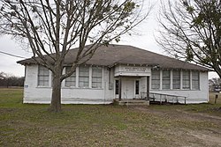
Old Myrtle Springs School
Myrtle Springs, Texas
Coordinates: 32°37′24″N95°55′48″W / 32.62333°N 95.93000°W / 32.62333; -95.93000
Country United States
State Texas
County Van Zandt
Area
  Total
7.4 sq mi (19.2 km2)
  Land7.3 sq mi (18.9 km2)
  Water0.1 sq mi (0.3 km2)
Elevation
[1]
522 ft (159 m)
Population
 (2010)
  Total
828
  Density110/sq mi (43/km2)
Time zone UTC-6 (Central (CST))
  Summer (DST) UTC-5 (CDT)
Zip Code
75169
GNIS feature ID2586962 [1]

Myrtle Springs is a census-designated place (CDP) in Van Zandt County, Texas, United States. It was a new CDP for the 2010 census with a population of 828. [2]

Contents

Geography

Myrtle Springs has a total area of 7.4 square miles (19 km2), of which 7.3 square miles (19 km2) are land and 0.1 square miles (0.26 km2) are water. [3]

Demographics

Historical population
CensusPop.Note
2010 828
2020 95415.2%
U.S. Decennial Census [4]
1850–1900 [5] 1910 [6]
1920 [7] 1930 [8] 1940 [9]
1950 [10] 1960 [11] 1970 [12]
1980 [13] 1990 [14] 2000 [15]
2010 [16]

Myrtle Springs first appeared as a census designated place in the 2010 U.S. Census. [16]

2020 census

Myrtle Springs CDP, Texas – Racial and ethnic composition
Note: the US Census treats Hispanic/Latino as an ethnic category. This table excludes Latinos from the racial categories and assigns them to a separate category. Hispanics/Latinos may be of any race.
Race / Ethnicity (NH = Non-Hispanic)Pop 2010 [17] Pop 2020 [18] % 2010% 2020
White alone (NH)72581187.56%85.01%
Black or African American alone (NH)1351.57%0.52%
Native American or Alaska Native alone (NH)350.85%0.52%
Asian alone (NH)330.36%0.31%
Native Hawaiian or Pacific Islander alone (NH)400.48%0.00%
Other race alone (NH)120.12%0.21%
Mixed race or Multiracial (NH)12341.45%3.56%
Hispanic or Latino (any race)63947.61%9.85%
Total828954 100.00%100.00%

References

  1. 1 2 U.S. Geological Survey Geographic Names Information System: Myrtle Springs, Texas
  2. "Population and Housing Unit Counts, 2010 Census of Population and Housing" (PDF). Texas: 2010. Archived from the original (PDF) on October 22, 2021. Retrieved January 2, 2017.
  3. "Boundary Map of Myrtle Springs, Texas". MapTechnica. Retrieved January 2, 2017.
  4. "Decennial Census by Decade". United States Census Bureau .
  5. "1900 Census of Population - Population of Texas By Counties And Minor Civil Divisions" (PDF). United States Census Bureau .
  6. "1910 Census of Population - Supplement for Texas" (PDF). United States Census Bureau .
  7. "1920 Census of Population - Number of Inhabitants - Texas" (PDF). United States Census Bureau .
  8. "1930 Census of Population - Number of Inhabitants - Texas" (PDF). United States Census Bureau .
  9. "1940 Census of Population - Number of Inhabitants - Texas" (PDF). United States Census Bureau .
  10. "1950 Census of Population - Number of Inhabitants - Texas" (PDF). United States Census Bureau .
  11. "1960 Census of Population - Number of Inhabitants - Texas" (PDF). United States Census Bureau .
  12. "1970 Census of Population - Number of Inhabitants - Texas" (PDF). United States Census Bureau .
  13. "1980 Census of Population - Number of Inhabitants - Texas" (PDF). United States Census Bureau .
  14. "1990 Census of Population - Population and Housing Unit Counts - Texas" (PDF). United States Census Bureau .
  15. "2000 Census of Population - Population and Housing Unit Counts - Texas" (PDF). United States Census Bureau .
  16. 1 2 "2010 Census of Population - Population and Housing Unit Counts - Texas" (PDF). United States Census Bureau .
  17. "P2: Hispanic or Latino, and Not Hispanic or Latino by Race – 2010: DEC Redistricting Data (PL 94-171) – Myrtle Springs CDP, Texas". United States Census Bureau .
  18. "P2: Hispanic or Latino, and Not Hispanic or Latino by Race – 2020: DEC Redistricting Data (PL 94-171) – Myrtle Springs CDP, Texas". United States Census Bureau .