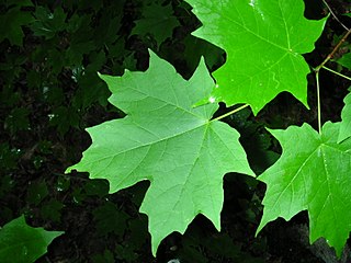
Acer saccharum, the sugar maple, is a species of flowering plant in the soapberry and lychee family Sapindaceae. It is native to the hardwood forests of eastern Canada, from Nova Scotia west through southern Quebec, central and southern Ontario to southeastern Manitoba around Lake of the Woods, and northcentral and northeastern United States, from Minnesota eastward to Maine and southward to northern Virginia, Tennessee and Missouri. Sugar maple is best known for being the primary source of maple syrup and for its brightly colored fall foliage. It may also be known as "rock maple", "sugar tree", "birds-eye maple", "sweet maple", "curly maple", or "hard maple", particularly when referring to the wood.

The District of Saanich is a district municipality on Vancouver Island in British Columbia, within the Greater Victoria area. The population was 114,148 at the 2016 census, making it the most populous municipality in the Capital Regional District and Vancouver Island, and the eighth-most populous in the province. The district adopted its name after the Saanich First Nation, meaning "emerging land" or "emerging people". The District acts as a bedroom community immediately to the north of Victoria, British Columbia.

Sidney is a town located at the northern end of the Saanich Peninsula, on in Vancouver Island in the Canadian province of British Columbia. It's 1 of the 13 Greater Victoria municipalities. It has a population of approximately 11,583. Sidney is located just east of Victoria International Airport, and about 6 km (4 mi) south of BC Ferries' Swartz Bay Terminal. The town is also the only Canadian port-of-call in the Washington State Ferries system, with ferries running from Sidney to the San Juan Islands and Anacortes. Sidney is located along Highway 17, which bisects the town from north to south. It is generally considered part of the Victoria metropolitan area.
Sehome, also called Sehome Hill, is a forested hill in Bellingham, Washington. The Sehome Hill Arboretum is an 180-acre (73-hectare) park of second growth forest is located on the hill, adjacent to the campus of Western Washington University. Though called an arboretum, the hilly expanse atop Sehome is not consciously planted as an exhibit of tree species, but naturally wooded and rich in the plant species typical of the region. The arboretum is jointly managed by both the university and the city. Its care is overseen by the Sehome Arboretum Board of Governors, composed of city employees, university employees, university students, and city residents. The park offers students and city dwellers over 5 miles (8 km) of public trails for walking and running and, in some areas, bicycling. Unique features of the park include an 80-foot (24 m) wooden observation tower atop Sehome, with aerial views of Bellingham Bay to the south. There is also a large tunnel, hand cut into rock in 1923, originally used for car traffic in the early 1900s. Its tall, thin shape shows its creation for cars like Model T Fords of the day. Cars are no longer allowed in the tunnel and it is part of a trail along which hikers can walk.

Ravenna Park and Cowen Park comprise a single contiguous recreation and green space in the Ravenna neighborhood of Seattle, Washington in the United States. These public parks encompass the ravine with a maximum depth of 115 feet (35 m) through which Ravenna Creek flows.

The Galloping Goose Regional Trail is a 55-kilometre (34 mi) rail trail between Victoria, British Columbia, Canada, and the ghost town of Leechtown, north of Sooke, where it meets the old Sooke Flowline. Maintained by the Capital Regional District (CRD), the trail forms part of the Trans-Canada Trail, and intersects the Lochside Regional Trail. The section from Harbour Road in Esquimalt to the Veterans Memorial Parkway in Langford is also part of the Vancouver Island Trail.

The District of North Saanich is located on the Saanich Peninsula of British Columbia, approximately 25 km (16 mi) north of Victoria on southern Vancouver Island. It is one of the 13 Greater Victoria municipalities. The District is surrounded on three sides by 20 km (12 mi) of ocean shoreline, and consists of rural/residential areas, a large agricultural base and is home to the Victoria International Airport and the Swartz Bay Ferry Terminal.

ȽÁU,WELṈEW̱/John Dean Provincial Park, formerly John Dean Provincial Park, is a small, densely vegetated provincial park on the Saanich Peninsula of southern Vancouver Island, British Columbia, Canada. The park is located on and around ȽÁU,WELṈEW̱, a small mountain in the traditional territory of Wsanec First Nations, itself situated 20 km north of Victoria, the provincial capital city.
Saanich Peninsula is located north of Victoria, British Columbia, Canada. It is bounded by Saanich Inlet on the west, Satellite Channel on the north, the small Colburne Passage on the northeast, and Haro Strait on the east. The exact southern boundary of what is referred to as the "Saanich Peninsula" is somewhat fluid in local parlance.
Maple Bay is a seaside community located in the Cowichan Valley of southern Vancouver Island, British Columbia, Canada. A narrow inlet and surrounded by smooth, pebbled beaches, Maple Bay is home to marine activity all year round. Maple bay is a small town with a population of 2,640

Eagle Heights is an elevated area located south of Koksilah Ridge on Vancouver Island, British Columbia, Canada. It is centered at 48°40′N, 123°46′W. Its summit lies about 836 meters above sea level. Populated areas where it is visible include North Saanich, Sidney, and Shawnigan Lake.

Gordon Head is a seaside neighbourhood in the municipality of Saanich in Greater Victoria, British Columbia, Canada. Gordon Head lies north of McKenzie Avenue and east of the Blenkinsop Valley. The University of Victoria is located partly within Gordon Head along the southeast boundary. Finnerty Road separates Gordon Head from the adjacent neighbourhood of Cadboro Bay. The local area is dominated physically by Mount Douglas, a coastline along Haro Strait, and the central plateau.

The Elk/Beaver Regional Park is a 1,072 acres (4.34 km2) park in Saanich, British Columbia, containing Elk Lake and Beaver Lake.
The Hartland landfill is the waste disposal site for the city of Victoria, British Columbia and the Greater Victoria area. The landfill began operating in the early 1950's under private ownership and management. Phase 1 of the landfill reached capacity in 1996, Phase 2 filled in Heal Lake which was drained and was 2.5-hectares. The landfill was later purchased by the Capital Regional District in 1975 and has been directly operated by its Environmental Sustainability Department since 1985. The landfill, located in the District of Saanich on the southern slope of Mount Work, between Victoria and Sidney, at the end of Hartland Avenue is adjacent to Mount Work Regional Park to the west and the Department of National Defence rifle range is located across Willis Point Road to the northeast. To the east and southeast of the site are residential properties. Undeveloped CRD property lies to the west and south of the landfill site and is now being used by CRD Parks as a mountain bike recreation area under a land use agreement. Private residential properties exist to the east and southeast of the landfill.

The North Saskatchewan River valley parks system is a continuous collection of urban parks in the North Saskatchewan River valley of Edmonton, Alberta. The parks range from waterside to cliff side to cliff top locations bordering the North Saskatchewan River.
Gryżyna Landscape Park is a protected area in western Poland, established in 1996, covering an area of 27.55 square kilometres (10.64 sq mi).
The University of Wisconsin–Madison Lakeshore Nature Preserve is a 300-acre (1.2 km2) nature reserve along 4 miles (6.4 km) of the southern shore of Lake Mendota. The preserve's primary goals are to protect native plant and animal communities, as well as to uphold the campus's signature natural landscapes, all while providing an educational facility for the university.

The Sooke Flowline is an abandoned 44-kilometre (27 mi) concrete aqueduct that snakes through the Sooke Hills from Sooke Lake to the Humpback Reservoir near Mt. Wells Regional Park. From this reservoir, a buried, riveted steel pressure main transported water to Victoria. In between 1994 and 2007, this main was replaced since it was long past its useful life. The flowline was vital to the continued growth of the City of Victoria as it provided a reliable water supply. While the flowline remains, Victoria's water supply is now carried via Kapoor tunnel. Leigh Hodgetts, CRD Waterworks superintendent, reported that the westernmost section of the flowline is still used to carry Sooke's water supply, via a 16 inch interconnecting pipe feeding the Sooke distribution system from Charters Creek to Sooke River Road.
Haro Woods is one of the few urban forests remaining in the Municipality of Saanich, one of the 13 municipalities which make up the Capital Regional District (CRD) on the south portion of Vancouver Island. It is similar in beauty to Mystic Vale, the forested ravine located to the south east and outside of the University of Victoria (UVIC) campus. Mystic Vale is on the list of protected areas of British Columbia.


