
Mysore, officially Mysuru, is a city in the southern part of the state of Karnataka, India. Mysore city is geographically located between 12° 18′ 26″ north latitude and 76° 38′ 59″ east longitude. It is located at an altitude of 770 m (2,530 ft) above mean sea level.

Srirangapatna, is a town and is the headquarters of one of the seven Taluks of Mandya district, in the Indian State of Karnataka. It gets its name from the Ranganthaswamy temple consecrated at around 984 CE. Later, under the British rule the city was renamed to Seringapatnam. Located near the city of Mandya, it is of religious, cultural and historic importance.

Palakkad District is one of the 14 districts in the Indian state of Kerala. It was carved out from the southeastern region of the former Malabar District on 1 January 1957. It is located at the centre of Kerala. It is the largest district in the state since 2006. The city of Palakkad is the district headquarters. Palakkad is bordered on the northwest by the Malappuram district, on the southwest by the Thrissur district, on the northeast by Nilgiris district, and on the east by Coimbatore district of Tamil Nadu. The district is nicknamed "The granary of Kerala". Palakkad is the gateway to Kerala due to the presence of the Palakkad Gap, in the Western Ghats. The 2,383 m high Anginda peak, which is situated in the border of Palakkad district, Nilgiris district, and Malappuram district, in Silent Valley National Park, is the highest point of elevation in Palakkad district. Palakkad city is located just 50 km away from Coimbatore, a major city in Tamil Nadu state.

Mysore district, officially Mysuru district is an administrative district located in the southern part of the state of Karnataka, India. It is the administrative headquarters of Mysore division.Chamarajanagar District was carved out of the original larger Mysore District in the year 1998. The district is bounded by Chamrajanagar district to the southeast, Mandya district to the east and northeast, Kerala state to the south, Kodagu district to the west, and Hassan district to the north.
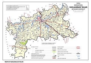
Nanjangud, officially known as Nanjanagudu, is a town in the Mysuru district of Indian state of Karnataka. Nanjangud lies on the banks of the river Kapila, 23 km from the city of Mysore. Nanjangud is famous for the Srikanteshwara Temple located here. Nanjangud is also called Dakshina Kashi. This town is also famous for a type of banana grown in the region called the Nanjanagoodu rasabale. Nanjangud's local administrative unit was designated as a Municipal Committee in 2015 by including Devirammanahalli and Kallahalli village.

Mysore division, officially Mysuru division, is an administrative division in the southern Indian state of Karnataka. It is one of four administrative divisions in Karnataka, the others being Bangalore division, Belgaum division, and Gulbarga division. Mysore division comprises eight districts of Karnataka, namely, Chamarajanagar, Chikmagalur, Dakshina Kannada, Hassan, Kodagu, Mandya, Mysore and Udupi district. The city of Mysore is the administrative headquarters of the division. Mysore division covers parts of historical Old Mysore region and southern part of Coastal Karnataka.The total area of the division is 43,503 sq.km. The total population as of 2011 census is 12,563,598.

Hassan is a city in Hassan taluk and headquarters of Hassan district, in southern part of Karnataka.

Kushalanagara or Kushalnagar is a city located in the Kodagu district of the Indian state of Karnataka. Surrounded by Kaveri river, it is the gateway to Kodagu district. It also serves as the headquarters of Kushalanagar Taluk. By population, Kushalanagar is the second largest town in Kodagu district after Madikeri and the fastest developing town in the district. Kushalnagar is an important commercial centre in Kodagu.

Bhogadi is a town within the limits of the Mysore Urban Development Authority, and Mysuru metropolitan area in Mysore district, Karnataka.

Channarayapatna is a town and Taluk headquarters in Hassan district of Karnataka, India. It lies on the Bangalore-Mangalore National Highway 75 in Karnataka, India.It has number of temples like Channakeshava temple, Anjaneya temple, Tejigereyamma temple... etc. Famous Jain pilgrimage Shravanbelogola belongs to this taluk. Channarayapatna has major railway connection from Bengaluru to Mangaluru, Karwar and Mysuru.

Hinkal is a Census town situated at the intersection of Hunsur Road aka NH275 and Ring Road aka NH 275K in Mysore city outskirts of Karnataka, India. It is the most populous census town in Mysore district. The nearest railway station located is Mysore Junction railway station.
Kadakola is a Town and a suburb of Mysuru metropolitan area in the southern state of Karnataka, India. It is located in the Mysore taluk of Mysore district. In November 2020, Kadakola was upgraded from a Gram Panchayat to a Town Panchayat and a gazetted notification was passed on November 26, 2020.2. The combined population of the newly formed town is 19,969.
Rammanahalli is a Town and a suburb of Mysore in the Mysuru metropolitan area of Karnataka, India. It is located in the Mysore taluk of Mysore district. In November 2020, Kadakola was upgraded from a Gram Panchayat to a Town Panchayat and a gazetted notification was passed on November 26th 2020. The notification combines Rammanahalli GP villages, Nadanahalli and Alanahalli of Alanahalli GP, Hanchya and Sathagalli villages of Hanchya GP, covering a total area of 22.81 sq. km. The combined population of the town according to 2011 census was 20,804.

Hebbal is an industrial area and suburb of Mysore city in India.

The MysoreUrban Development Authority (MUDA) of Mysore, India, is a governmental organization that oversees planning and development of infrastructure, provision of development-related sites and services, and the housing needs of underprivileged citizens in Mysore.

Mysore City Corporation (MCC) is the administrative body responsible for civic amenities and infrastructural assets of Mysore city in Karnataka, India. It is the third-largest municipal corporation in Karnataka, serving a population of 1,000,000 in an area of 235 km2. The city's boundaries have expanded more than twice between 2010 and 2020.
Srirampura is a town and residential suburb of Mysore city in India. It is located in the Southern part of the city. It has a population of approximately 11,000 according to the 2011 Census. The main landmarks of this area are Brahmarahbha Choultrey, SBM park, Madhuvana Park. There are several schools in and around this area. North of Srirampura is Vivekananda Nagar and Kuvempunagar. West of Srirampura is Ramakrishnanagar, East of Srirampura is Asokapuram. South of Srirampura is the Mananthavady-Mysore Highway. In November 2020, a gazetted notification was passed upgrading the census town to a town panchayat. The notification combines towns and villages of Srirampura, Lingambudhipalya, Gurur, Koppalur and Kalalavadi villages coming under Srirampura GP, covering a total area of 17.99 sq. km. According to 2011 census, the town has a combined population of 18,511.
H C Mahadevappa is an Indian politician from the state of Karnataka.He belongs to Hadinaru, a village in Nanjangud taluk of Mysuru district.He pursued his early education in his village and later continued his studies in Mysuru and went on to study medicine. He was a member of the Karnataka Legislative Assembly and represented Tirumakudal Narsipur constituency.

Hootagalli or Hutagalli is a city and a Suburb of Mysore, situated in Mysuru metropolitan area ಮೈಸೂರು ಜಿಲ್ಲೆ of Karnataka, India. Hootagalli is located in the outskirts of the city of Mysuru and forms a continuous urban area. Hootagalli city municipal council consists of previous census towns of Hinkal, Hootagalli and Gram Panchyats of Koorgalli and Belavadi totally covering an area of 28.48 square km. In November 2020, the government of Karnataka approved the formation of Hootagalli City Municipal Council by merging four gram panchayats. The initial plan was to include it with MCC to form Greater Mysuru City Corporation (BMMP) however, due to MCC disputing the proposal, a separate body was created. According to 2011 census, the city municipal council has combined population of 56,876. On November 26, 2020, a gazetted notification was passed making the CMC official.

KRS Nisarga Township is a mega housing project by Karnataka Housing Board formed in northwestern Mysuru. KRS Nisagra was named as it is right next to the Krishna Raja Sagara - KRS dam location. The layout has 6,309 sites, 207 houses, 18 civic amenity site, 12 commercial complexes and 54 parks.
