Related Research Articles
The Stʼatʼimc, also known as the Lillooet, St̓át̓imc, Stl'atl'imx, etc., are an Interior Salish people located in the southern Coast Mountains and Fraser Canyon region of the Interior of the Canadian province of British Columbia.

The Squamish-Lillooet Regional District is a quasi-municipal administrative area in British Columbia, Canada. It stretches from Britannia Beach in the south to Pavilion in the north. Lillooet, Pemberton, Whistler and Squamish are the four municipalities in the regional district. Its administrative offices are in the Village of Pemberton, although the district municipalities of Squamish, Whistler, and Lillooet are all larger population centres. The district covers 16,353.68 km² of land area.

Seton Portage is a community located on a narrow strip of land between Anderson Lake and Seton Lake in Squamish-Lillooet Regional District, British Columbia. The community is home to two Seton Lake First Nation communities at either end of the portage and a non-native recreational community between them. Local services include a post office, fire department, library, and general store, among other small businesses. The community is also the location of Seton Portage Historic Provincial Park, a small provincial park protecting a historically significant stretch of railway.

Shalalth, pop. c. 400, is one of the main communities of the Seton Lake Band of the St'at'imc (Lillooet) Nation and location of the two main powerhouses of the Bridge River Power Project.
The Skatin First Nations, aka the Skatin Nations, are a band government of the In-SHUCK-ch Nation, a small group of the larger St'at'imc people who are also referred to as Lower Stl'atl'imx. The Town of Skatin - the St'at'imcets version of the Chinook Jargon Skookumchuck- is located 4 km south of T'sek Hot Spring- alt. spelling T'sek Hot Spring - commonly & formerly named both St. Agnes' Well & Skookumchuck Hot Springs The community is 28 km south of the outlet of Lillooet Lake on the east side of the Lillooet River. It is approximately 75 km south of the town of Pemberton and the large reserve of the Lil'wat branch of the St'at'imc at Mount Currie. Other bands nearby are Samahquam at Baptiste Smith IR on the west side of the Lillooet River at 30 km. and Xa'xtsa First Nations; the latter is located at Port Douglas, near the mouth of the Lillooet River where it enters the head of Harrison Lake. The N'Quatqua First Nation on Anderson Lake, between Mount Currie and Lillooet, was at one time involved in joint treaty negotiations with the In-SHUCK-ch but its members have voted to withdraw, though a tribal council including the In-SHUCK-ch bands and N'Quatqua remains, the Lower Stl'atl'imx Tribal Council.

The Douglas Road, a.k.a. the Lillooet Trail, Harrison Trail or Lakes Route, was a goldrush-era transportation route from the British Columbia Coast to the Interior. Over 30,000 men are reckoned to have travelled the route in, although by the end of the 1860s it was virtually abandoned due to the construction of the Cariboo Wagon Road, which bypassed the region.

The Birkenhead River, formerly known as the Portage River, the Pole River and the Mosquito River, is a major tributary of the Lillooet River, which via Harrison Lake and the Harrison River is one of the major tributaries of the lower Fraser River. It is just over 50 km long from its upper reaches in the unnamed ranges south of Bralorne, British Columbia ; their western area towards the named Bendor Range east of Bralorne is sometimes called the Cadwallader Ranges.
The Lillooet Tribal Council is the official English name of the largest tribal council of what is also known as the St'at'imc Nation, though not including all governments of St'at'imc peoples - the term St'at'imc Nation has another context of all St'at'imc peoples, not just those within this tribal council or the tribal council itself, as the term can be used for. The Lillooet Tribal Council a.k.a. the St'at'imc Nation is the largest tribal council of the St'at'imc people, though a pan-St'at'imc organization, the St'át'timc Chiefs Council includes all St'at'imc bands.
The Bridge River Indian Band also known as the Nxwísten First Nation, the Xwisten First Nation, and the Bridge River Band, is a First Nations government located in the Central Interior-Fraser Canyon region of the Canadian province of British Columbia. It is a member of the Lillooet Tribal Council, which is the largest grouping of band governments of the St'at'imc people.
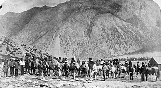
Chief Hunter Jack was a 19th-century chief of the Lakes Lillooet. His name in St'at'imcets, the Lillooet language, was In-Kick-Tee. Irene Edwards, long-time storekeeper at D'arcy and later at Seton Portage, gives another Indian name for him, Tash Poli.
D'Arcy is an unincorporated community in the Canadian province of British Columbia, approximately 150 kilometres northeast of the city of Vancouver. Located at the head of Anderson Lake, D'Arcy, also known as Nequatque or N'Quatqua in the St'at'imcets (Lillooet) language, is partly a recreational and resource community and also the territory and residential area of the N'Quatqua First Nation.

The Seton Lake First Nation, a.k.a. the Seton Lake Indian Band, is a First Nations government located in the Central Interior-Fraser Canyon region of the Canadian province of British Columbia. It is a member of the Lillooet Tribal Council, which is the largest grouping of band governments of the St'at'imc people. Other St'at'imc governments include the smaller In-SHUCK-ch Nation on the lower Lillooet River to the southwest, and the independent N'quatqua First Nation at the farther end of Anderson Lake from Seton Portage, which is the location of three of the band's reserve communities.

The Lil'wat First Nation, a.k.a. the Lil'wat Nation or the Mount Currie Indian Band, is a First Nation band government located in the southern Coast Mountains region of the Interior of the Canadian province of British Columbia. It is a member of the Lillooet Tribal Council, which is the largest grouping of band governments of the St'at'imc or Stl'atl'imx people. Other St'at'imc governments include the smaller In-SHUCK-ch Nation on the lower Lillooet River to the southwest, and the independent N'quatqua First Nation at the near end of Anderson Lake from Mount Currie, which is the main reserve of the Lil'wat First Nation, and also one of the largest Indian reserves by population in Canada.
The T'it'q'et First Nation also known as the T'it'k'it First Nation, the Tl'itl'kit First Nation and as the Lillooet Indian Band, is a First Nations government located in the Central Interior-Fraser Canyon region of the Canadian province of British Columbia. It is a member of the Lillooet Tribal Council, which is the largest grouping of band governments of the St'at'imc people. Other St'at'imc governments include the smaller In-SHUCK-ch Nation on the lower Lillooet River to the southwest, and the independent N'quatqua First Nation at the farther end of Anderson Lake from Seton Portage, which is the location of three of the reserve communities of the Seton Lake First Nation, another member of the Lillooet Tribal Council.
The N'Quatqua First Nation, also known as the N'quatqua Nation, the N'Quatqua Nation, the Nequatque First Nation, the Anderson Lake Indian Band, the Anderson Lake First Nation and the Anderson Lake Band, is a First Nations government of the St'at'imc people, located in the southern Coast Mountains region of the Canadian province of British Columbia at the community of D'Arcy, where the British Columbia Railway meets the head of Anderson Lake, about midway between the towns of Pemberton and Lillooet.
The Lillooet Country, also referred to as the Lillooet District, is a region spanning from the central Fraser Canyon town of Lillooet west to the valley of the Lillooet River, and including the valleys in between, in the Southern Interior of British Columbia. Like other historical BC regions, it is sometimes referred to simply as The Lillooet or even Lillooet,.
Pemberton Pass, 505 m (1,657 ft), also formerly known as Mosquito Pass, is the lowest point on the divide between the Lillooet and Fraser River drainages, located at Birken, British Columbia, Canada, in the principal valley connecting and between Pemberton and Lillooet. The pass is a steep-sided but flat-bottomed valley adjacent to Mount Birkenhead and forming a divide between Poole Creek, a tributary of the Birkenhead River, which joins the Lillooet at Lillooet Lake, and the Gates River which flows northeast from Gates Lake, at the summit of the pass, which flows to the Fraser via Anderson and Seton Lakes and the Seton River.
The Gates River is a short river in the Lillooet Country of the Southern Interior of British Columbia, Canada. Approximately 14.5 km in length, it flows generally northeast from the outlet of Birken Lake to its mouth at the head of Anderson Lake. Its main tributaries are Haylmore Creek, from the southeast, and Blackwater Creek, from the northwest, which originates near the head of Birkenhead Lake. Augmented by the waters of McGillivray Creek, Lost Valley Creek and others, its flow becomes the Seton River from the foot of Anderson Lake onwards.
The Gates Valley is a valley and group of communities in the Lillooet Country of the Southern Interior of British Columbia, Canada, located between the summit of Pemberton Pass and the head of Anderson Lake at the community of D'Arcy. Though the term strictly refers to the valley of the Gates River, it is usually used more in a sense of the communities located in the valley and is not a term used for the river's drainage basin, which is much larger.

Cayoosh Creek is a northeast-flowing tributary of the Seton River in the Canadian province of British Columbia. The name Cayoosh Creek remains on the bridge-sign crossing the stream on BC Highway 99 and continues in use locally to refer to the final reaches of the Seton River, formerly Seton Creek, which prior to the renaming ending at the confluence with Cayoosh Creek. The creek is the namesake of Cayoosh Creek Indian Reserve No. 1, one of the main Indian reserves of the Cayoose Creek Indian Band, which lies adjacent to what was renamed the Seton River without local consultation.
References
- N'Quatqua website
- Tales from Seton Portage, Irene Edwards, self.publ. Lillooet 1976
- "Nequatque Indian Reserve 1". BC Geographical Names .
Coordinates: 50°33′00″N122°29′00″W / 50.55000°N 122.48333°W