Naggar, Himachal Pradesh

Last updated

Naggar
NaggarCastleRainyDay.jpg
India Himachal Pradesh location map.svg
Red pog.svg
Naggar
Location in Himachal Pradesh, India
India location map.svg
Red pog.svg
Naggar
Naggar (India)
Coordinates: 32°07′N77°10′E / 32.12°N 77.17°E / 32.12; 77.17
Country Flag of India.svg  India
State Himachal Pradesh
District Kullu
Elevation
1,800 m (5,900 ft)
Languages
  Official Hindi
Time zone UTC+5:30 (IST)
Vehicle registration HP
Sex ratio 9:8 /

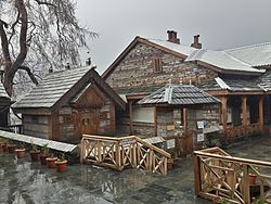
Situated on the left bank of river Beas at an altitude of 1,800 meters, Naggar is an ancient town in Kullu district of Himachal Pradesh, India. It was once capital of the Kullu kingdom. [1]

Contents

Geography

Naggar is located 22 kilometres (14 mi) north of the District headquarters at Kullu and 230 kilometres (140 mi) north of the state capital at Shimla.

It is bound by Kullu Tehsil towards South, Spiti Tehsil towards East, Drang Tehsil towards South and Lahul Tehsil towards North. Manali, Keylong, Mandi, Sundarnagar and Hamirpur are some of the nearby towns to Naggar.

Climate

The climate in Naggar is mild. In winter, there is much less rainfall than in summer. The average temperature is 16.6 °C. In a year, the average rainfall is 1,730 mm. [2]

History

Naggar was the capital of the erstwhile Kullu Rajas for about 1400 years. It was founded by the Visudh Pal and remained as the State headquarters until the capital was transformed to Kullu (Sultanpur) by Raja Jagat Singh.

Naggar Castle, the official seat of kings for centuries. was built by Raja Sidh Singh more than 500 years ago. According to a legend, he used stones from the abandoned palace (Gardhak) of Rana Bhonsal to build the castle. [3] He ordered the labourers to form a human chain over the Beas river connecting its left and right banks to transfer the stones manually. The castle survived the earthquake of 1905. While most houses in the valley and the nearby city of Jawa were completely ruined, the castle's use of earthquake-proof techniques helped it sustain despite the calamity.

Himalayan Research Institute named Urusvati in Naggar. Urusvati base.jpg
Himalayan Research Institute named Urusvati in Naggar.

In 1978 it was taken over to Himachal Pradesh Tourism Development Corporation (HPTDC), to run as a heritage hotel. [5] [6]

The Russian painter and explorer Nicholas Roerich settled in Naggar in the early 20th century. The Roerich Estate, his two-floor house, is now a museum and key attraction of the town featuring a collection of his popular paintings. [7]

Transport

Air

The nearest airport is Bhuntar Airport in Kullu (IATA code KUU) located in Bhuntar town at a distance of 40.2 km (25 mi) from Naggar. The airport is situated on NH21 at a distance of 10 km (6 mi) south of Kullu and about 50 km (31 mi) south of Manali. Also known as Kullu-Manali airport, Bhuntar Airport has more than one kilometre long runway. Air India has regular flights to the airport from New Delhi.

Rail

The nearest narrow gauge railhead is at Joginder Nagar. One can travel to this railway station via Pathankot Junction, and further by a taxi or cab.

Road

Naggar is easily accessible through the buses run by HPTDC. These buses ply from Manali to Naggar via Khaknal. The road distance from Manali to Naggar via NH3 is 22 km (13.6 mi) while via Khaknal is 21 km (13 mi).

Access

Car of Nicolas Roerich in his museum at Naggar NicholasRoerichcar.jpg
Car of Nicolas Roerich in his museum at Naggar
View of Beas and Kullu from the castle Naggar Castle city view.jpg
View of Beas and Kullu from the castle

Attractions

Fruit shop in Naggar Fruitshop.JPG
Fruit shop in Naggar
View of town from Naggar Castle View naggar.jpg
View of town from Naggar Castle

Related Research Articles

<span class="mw-page-title-main">Himachal Pradesh</span> State in northern India

Himachal Pradesh is a state in the northern part of India. Situated in the Western Himalayas, it is one of the thirteen mountain states and is characterized by an extreme landscape featuring several peaks and extensive river systems. Himachal Pradesh is the northernmost state of India and shares borders with the union territories of Jammu and Kashmir and Ladakh to the north, and the states of Punjab to the west, Haryana to the southwest, Uttarakhand to the southeast and a very narrow border with Uttar Pradesh to the south. The state also shares an international border to the east with the Tibet Autonomous Region in China. Himachal Pradesh is also known as Dev Bhoomi or Dev Bhumi, meaning 'Land of Gods' and Veer Bhoomi which means 'Land of the Brave'.

<span class="mw-page-title-main">Kullu district</span> District of Himachal Pradesh, India

Kullu is a district in Himachal Pradesh, India. It borders Shimla district to the south, Mandi and Kangra districts to the west, and the Lahaul and Spiti district to the north and east. The largest valley in this mountainous district is the Kullu Valley. The Kullu valley follows the course of the Beas River, and ranges from an elevation of 833m above sea level at Aut to 3330m above sea level at the Atal Tunnel South Portal, below the Rohtang Pass. The town of Kullu, located on the right side of the Beas River, serves as the administrative headquarters of the Kullu district. The Kullu district also incorporates several riverine tributary valleys of the Beas, including those of the Parvati, Sainj, and Tirthan rivers, and thus some regions somewhat distant from the Kullu valley. The economy of the district relies mainly on horticulture, agriculture, tourism, and traditional handicrafts.

<span class="mw-page-title-main">Manali, Himachal Pradesh</span> Town in India

Manali is a town, near Kullu town in Kullu district in the Indian state of Himachal Pradesh. It is situated in the northern end of the Kullu Valley, formed by the Beas River. The town is located in the Kullu district, approximately 270 kilometres (170 mi) north of the state capital of Shimla and 544 kilometres (338 mi) northeast of the national capital of New Delhi. With a population of 8,096 people recorded in the 2011 Indian census Manali is the beginning of an ancient trade route through Lahaul (H.P) and Ladakh, over the Karakoram Pass and onto Yarkand and Hotan in the Tarim Basin of China. Manali is a popular tourist destination in India and serves as the gateway to the Lahaul and Spiti district as well as the city of Leh in Ladakh.

Bilaspur is a town and a municipal council in Bilaspur district in the Indian state of Himachal Pradesh.

<span class="mw-page-title-main">Kullu</span> Town in Himachal Pradesh, India

Kullu is a municipal council town that serves as the administrative headquarters of the Kullu district of the Indian state of Himachal Pradesh. It is located on the banks of the Beas River in the Kullu Valley about 10 kilometres (6.2 mi) north of the airport at Bhuntar, Kullu.

<span class="mw-page-title-main">Shimla district</span> District of Himachal Pradesh in India

Shimla district is one of the twelve districts of the state of Himachal Pradesh in northern India. Its headquarters is the state capital of Shimla. Neighbouring districts are Mandi and Kullu in the north, Kinnaur in the east, Uttarakhand in the southeast, Solan to the southwest and Sirmaur in the south. The elevation of the district ranges from 987 metres (3,238 ft) to 4,500 metres (14,764 ft).

<span class="mw-page-title-main">Geography of Himachal Pradesh</span>

The state of Himachal Pradesh is spread over an area 55,673 km2 (21,495 sq mi) and is bordered by Jammu and Kashmir and Ladakh on the north, Punjab on the southwest, Haryana on the south, Uttarakhand on the southeast, a small border with Uttar Pradesh in the south, and Tibet on the east. Entire Himachal Pradesh lies in the mountainous Himalaya region, rich in natural resources

<span class="mw-page-title-main">Bhuntar</span> Town in Himachal Pradesh, India

Bhuntar is a town and a nagar panchayat in Kullu district in the state of Himachal Pradesh, India. It is just 11 km from Kullu town, and lies along National Highway 3. The Kullu Airport is located in Bhuntar. Bhuntar is located on the right bank of the Beas River. Right opposite to Bhuntar, near the left bank of the Beas River, there is the confluence of the Parvati River with the River Beas. The Parvati Valley begins at this confluence and runs eastward, through a steep-sided valley towards Kasol and Manikaran.

<span class="mw-page-title-main">Sundar Nagar</span> Town in Himachal Pradesh, India

Sundar Nagar is a town and a municipal council in Mandi district in the Indian state of Himachal Pradesh. It was formerly a princely state, known as Suket.

Raison is a stopover which has vast camping grounds maintained by Himachal Pradesh Tourism.

<span class="mw-page-title-main">Jogindernagar</span> Municipality and Hill Station in Himachal Pradesh, India

Jogindernagar, or Jogindar Nagar, is a municipality, and a sub district in Mandi district in the Indian state of Himachal Pradesh. Named after Raja Joginder Sen, the hill station is the terminus of the 163-kilometre-long (101 mi) Kangra Valley narrow-gauge railway. Jogindernagar is the third-largest city in the Mandi district. The only city in Asia with three hydro-electric power stations, its nickname is "The City of Powerhouses".

<span class="mw-page-title-main">Kullu Manali Circuit</span>

The Kullu Manali Circuit is a tourist route in India. The initial entry point to Kullu Manali Circuit is from Chandigarh, India. Most of the stopovers and destinations lies on the National Highway No. 21. This highway originates from Chandigarh and ends at Manali. This path from Chandigarh to Manali followed by National Highway No 21. The circuit is categorised into 4 main segments:-

Himachal Pradesh, although railways and airways serve very limited transport needs, the road network of the state serves the transport needs of the people. Although, the geography of Himachal presents considerable challenge to the development of transport infrastructure, it has the highest road density among all the Hill States of India. Himachal also has 3 airports, 2 narrow gauge rail tracks and couple of other under-construction broad gauge railway tracks, but roads remain the main mode of transport.

<span class="mw-page-title-main">Sar Pass Trek</span> Mountain Pass in Himachal Pradesh, India

The Sar Pass is in Parvati Valley of Kullu district of Himachal Pradesh, a state of India.

<span class="mw-page-title-main">Kullu–Manali Airport</span> Airport of Himachal Pradesh, India

Kullu–Manali Airport, also called Bhuntar Airport is a domestic airport serving the cities of Kullu and Manali in the Indian state of Himachal Pradesh. The airport is located at Bhuntar, 11 km from Kullu town and 52 km from Manali.

<span class="mw-page-title-main">Mandi, Himachal Pradesh</span> City in Himachal Pradesh, India

Mandi is a major city and a municipal corporation in Mandi District in the Indian state of Himachal Pradesh. It is situated 145 kilometres (90 mi) north of state capital, Shimla in the north-west Himalayas at an average altitude of 880 m (2,890 ft) Mandi is connected to the Pathankot through National Highway 20 and to Manali and Chandigarh through National Highway 21. Mandi is approximately 184.6 km (114.7 mi) from Chandigarh, the nearest major city, and 440.9 km (274.0 mi) from New Delhi, the national capital. In the 2011 Indian census, Mandi city had a population of 26,422. Mandi district is currently the 4th largest economy in the state. Mandi has the second highest sex ratio of 1013 females per thousand males, in the state.

<span class="mw-page-title-main">Tourism in Himachal Pradesh</span> Tourism in the Indian state of Himachal Pradesh

Tourism in Himachal Pradesh relates to tourism in the Indian state of Himachal Pradesh. This is popularly renowned for its Himalayan landscapes and popular hill-stations. Many outdoor activities such as rock climbing, mountain biking, paragliding, ice-skating, trekking, rafting, and heli-skiing are popular tourist attractions in Himachal Pradesh.

<span class="mw-page-title-main">Nirmand</span> Village in Himachal Pradesh, India

Nirmand is a village located in Kullu district, of the Indian state of Himachal Pradesh. It is one of the largest villages in Himachal Pradesh and serves as the headquarters of Nirmand Tehsil and Nirmand developmental block of Kullu district.

<span class="mw-page-title-main">Jahu, Himachal Pradesh</span> Village in Himachal Pradesh, India

Jahu is a village panchayat in Bhoranj tehsil, of the Hamirpur district, Himachal Pradesh, India. Jahu is on a trijunction of Hamirpur, Bilaspur and Mandi districts.

<span class="mw-page-title-main">Naggar Castle</span> Medieval castle, located in Kullu, Himachal Pradesh, India

Naggar Castle is a medieval castle, located in Kullu, Himachal Pradesh, India. Built by Raja Sidh Singh of Kullu in around 1460 A.D, it was taken over to Himachal Pradesh Tourism Development Corporation (HPTDC), to run as a heritage hotel, since 1978.

References

  1. Denis, Eric; Zérah, Marie-Hélène (1 March 2017). Subaltern Urbanisation in India: An Introduction to the Dynamics of Ordinary Towns. Springer. ISBN   9788132236160.
  2. "Climate Naggar: Temperature, Climate graph, Climate table for Naggar - Climate-Data.org". en.climate-data.org. Retrieved 22 September 2017.
  3. "The Sunday Tribune – Spectrum". www.tribuneindia.com. Retrieved 22 September 2017.
  4. Ajay Kamalakaran (2 May 2012). "Nicholas Roerich's legacy lives on in Himalayan Hamlet". rbth.com. Retrieved 31 May 2021.
  5. "The Castle, Naggar". hptdc.in. Archived from the original on 19 June 2018. Retrieved 19 June 2018.
  6. "Tourism in Naggar". tourism-of-india.com. Archived from the original on 19 June 2018. Retrieved 19 June 2018.
  7. Kamalakaran, Ajay (2 May 2012). "Nicholas Roerich's legacy lives on in Himalayan Hamlet" . Retrieved 19 September 2017.
  8. "Himachal Tourism". Himachal Tourism Department. Archived from the original on 24 March 2010. Retrieved 12 April 2020.