Nahalal

Last updated • 4 min readFrom Wikipedia, The Free Encyclopedia
Nahalal
נַהֲלָל
nhll - zAb SHtyyn.jpg
Aerial view of Nahalal
Israel outline jezreel.png
Red pog.svg
Nahalal
Israel location map with stripes.svg
Red pog.svg
Nahalal
Coordinates: 32°41′24″N35°11′48″E / 32.69000°N 35.19667°E / 32.69000; 35.19667
CountryFlag of Israel.svg  Israel
District Northern
Council Jezreel Valley
Affiliation Moshavim Movement
Founded11 September 1921
Founded byJews from Eastern Europe
Population
 (2022) [1]
1,351

Nahalal (Hebrew : נַהֲלָל) is a moshav in northern Israel. Covering 8.5 square kilometers (3.3 sq mi), it falls under the jurisdiction of the Jezreel Valley Regional Council. In 2022 it had a population of 1,351. [1]

Contents

Nahalal is best known for its general layout, as designed by Richard Kauffmann: slightly oval round, similar to a spoke wheel, with its public buildings at the "hub" and individual plots of agricultural land radiating from it like spokes with symmetrically placed roads creating eight equal sectors, an inner ring of residential buildings, and an outer ring road. [2]

In the Hebrew Bible

Nahalal was a Levitical city mentioned in the Hebrew Bible. According to the Book of Joshua, Nahalal, also transliterated Nahallal, was located in the territory of the tribe of Zebulun (Joshua 19:15), and given to the Merarite division of the Levite tribe (Joshua 21:34–35). In the Book of Judges it is referred to as Nahalol (Judges 1:30).

History

Antiquity

Archaeological findings in the area suggest human settlement there dates to the Bronze Age, and continued into the Iron Age, Persian era, Hellenistic period, Roman era, and Byzantine era. Among the artifacts found was an ancient Jewish inscription of the word "Sabbath" on a rock, from Nahalal or nearby Shimron. [3]

Ottoman Empire: Ma'alul

An Arab village in the area, Ma'alul, was incorporated into the Ottoman Empire in 1517. It was identified with the biblical Nahalal by Rabbi Joseph Schwarz in 1850.[ citation needed ]

20th century

Arab village of Ma'alul

By the 20th century, Ma'alul's inhabitants were tenants of the Sursuq family of Beirut, absentee landlords who had acquired the land earlier. In 1921, they sold all but 2,000 dunams of Ma'alul's land to the Zionist Palestine Land Development Company. [4]

Moshav Nahalal

Nahalal in 1932 16-23-Nahalal-1932.jpg
Nahalal in 1932
Nahalal school 1944 byt hspr hKHqlAy lTS`yrvt bnhll-JNF021067.jpeg
Nahalal school 1944
Nahalal 1945 nhll - mKHsnym mrkzyym-JNF033897.jpeg
Nahalal 1945
Nahalal 1946 nhll - TSylvm Avyr SHl nhll-JNF035074.jpeg
Nahalal 1946

Nahalal was the first moshav ovdim (workers' cooperative agricultural settlement) in Mandatory Palestine. [5] Its founders immigrated to Palestine from Eastern Europe as part of the Second and Third Aliyah between 1904 and 1914, at the end of Ottoman rule.

Some of them had been members of the first kibbutz, Degania. After working in farming communities for a decade, they dreamt of establishing an income-sharing farming community similar to a kibbutz, but they wanted to maintain the nuclear family and household structure (kibbutzim had communal dining, and children were kept in separate housing, where they also slept). [6]

The founders first arrived to the lands given to them by the Jewish National Fund on September 11, 1921. They first saw the allotted land from the hill, noticing that small rivulets transformed the plain into marshes that attracted malaria-spreading anopheles mosquitoes. Heeding the warnings of experts, such as Dr. Hillel Yaffe, the Jewish pioneers temporarily settled on a nearby hill, near the Arab village of Ma'lul. Later they came down from the hill and divided the land, initially into 80 equal parcels, 75 to the members and 5 to Nahalal agricultural school.[ citation needed ][ dubious discuss ]

The physical layout of Nahalal, devised by architect Richard Kauffmann in 1921, [7] became the pattern for many moshavim established before 1948.[ citation needed ] It is based on concentric circles, with the public buildings (school, administration offices, services, and warehouses) in the centre, the homes of non-farming families (craftsmen, teachers, etc.) around the centre, then a ring street with the farmers' homesteads bordering on it on the outside, [2] and beyond those, ever-widening circles of gardens and fields.[ citation needed ] The equal parcelling of the land became the trademark geometric shape of Nahalal.[ citation needed ]

According to a census conducted in 1922 by the British Mandate authorities, Nahalal had a population of 437 Jews. [8]

On 22 December 1932, a member of Nahalal, Yosef Ya'akobi, and his 9-year-old son David [9] were killed when a bomb was thrown into their home. Halim Basta, a Coptic policeman for the Mandatory government solved the crime the following year, identifying followers of Izz ad-Din al-Qassam as the murderers. [10] In 1937, Basta was himself murdered.

Education

In 1929, a Girls' Agricultural Training Farm was established at Nahalal by Hana Meisel of the Women's International Zionist Organization. In the 1940s it became a co-educational farming school of the Youth Aliyah movement.

Notable residents

Ruth Westheimer RuthWestheimer-a.jpg
Ruth Westheimer
Ilan Ramon's grave in Nahalal Keverramon.jpg
Ilan Ramon's grave in Nahalal

Note:

Related Research Articles

<span class="mw-page-title-main">Ma'alul</span> Place in Nazareth, Mandatory Palestine

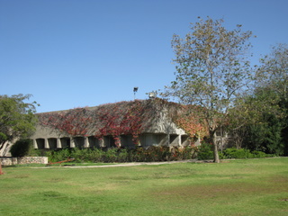
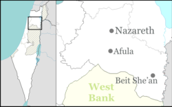
Ma'alul was a Palestinian village, with a mixed population of primarily Muslims with a substantial minority of Palestinian Christians, that was depopulated and destroyed by Israel during the 1948 Arab-Israeli war. Located six kilometers west of the city of Nazareth, many of its inhabitants became internally displaced refugees, after taking refuge in Nazareth and the neighbouring town of Yafa an-Naseriyye. Despite having never left the territory that came to form part of Israel, the majority of the villagers of Maalul, and other Palestinian villages like Andor and Al-Mujidal, were declared "absentees", allowing the confiscation of their land under the Absentees Property Law.

<span class="mw-page-title-main">Moshav</span> Type of cooperative Jewish agricultural community

A moshav is a type of Israeli village or town or Jewish settlement, in particular a type of cooperative agricultural community of individual farms pioneered by the Labour Zionists between 1904 and 1914, during what is known as the second wave of aliyah. A resident or a member of a moshav can be called a "moshavnik". There is an umbrella organization, the Moshavim Movement.

<span class="mw-page-title-main">Degania Alef</span> Kibbutz in northern Israel

Degania Alef is a kibbutz in northern Israel. The Jewish communal settlement (kvutza) was founded in 1910, making it the earliest Labor Zionist farming commune in the Land of Israel. Its status as "the mother of all kibbutzim" is sometimes contested based on a later distinction made between the smaller kvutza, applying to Degania in its beginnings, and the larger kibbutz.

<span class="mw-page-title-main">Kfar Etzion</span> Israeli settlement in the West Bank

Kfar Etzion is an Israeli settlement in the West Bank, organized as a religious kibbutz located in the Judean Hills between Jerusalem and Hebron in the southern West Bank, established in 1927, depopulated in 1948 and re-established in 1967. It is located 4.7 km east of the Green Line and falls under the jurisdiction of Gush Etzion Regional Council. In 2022, Kfar Etzion had a population of 1,371.

<span class="mw-page-title-main">Shmuel Dayan</span> Israeli politician (1891-1968)

Shmuel Dayan was a Zionist activist during the British Mandate of Palestine and an Israeli politician who served in the first three Knessets.

<span class="mw-page-title-main">Atarot</span> Site of destroyed Moshav in Mandatory Palestine

Atarot was a moshav in Mandatory Palestine, north of Jerusalem along the highway to Ramallah. It was named after the biblical Atarot mentioned in Joshua 16:2, which is believed to have been situated nearby. The moshav was captured and destroyed by the Jordanian Arab Legion during the 1948 Arab-Israeli War. Atarot Airport, closed since the Second Intifada, and Jerusalem's largest industrial park are now located there.

<span class="mw-page-title-main">Beit Hillel</span> Moshav in northern Israel

Beit Hillel is a moshav in northern Israel. Located on the west bank of the Hasbani River, about 5 kilometres from Kiryat Shmona, its 3,500 dunams fall under the jurisdiction of Mevo'ot HaHermon Regional Council. As of 2022, it had a population of 807.

<span class="mw-page-title-main">Moshava</span> Agricultural Jewish settlement in the region of Palestine (now Israel)

A moshava was a form of agricultural Jewish settlement in the region of Palestine, established by the members of the Old Yishuv beginning in the late 1870s and during the first two waves of Jewish Zionist immigration – the First and Second Aliyah.

<span class="mw-page-title-main">Kfar Yehezkel</span> Place in Northern, Israel

Kfar Yehezkel is a moshav in northern Israel. Located in the Jezreel Valley, six kilometres southeast of Afula, it falls under the jurisdiction of Gilboa Regional Council. In 2022 the moshav had a population of 1,242.

<span class="mw-page-title-main">Kfar Yehoshua</span> Moshav in northern Israel, between Haifa and Nazareth

Kfar Yehoshua is a moshav in northern Israel. Located between Haifa and Nazareth, it falls under the jurisdiction of Jezreel Valley Regional Council. In 2022 it had a population of 1,251.

<span class="mw-page-title-main">Kvutzat Kinneret</span> Place in Northern, Israel

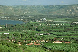
Kvutzat Kinneret, also known as Kibbutz Kinneret, is a kibbutz in northern Israel. The settlement group (kvutza) was established in 1913, and moved from the Kinneret training farm to the permanent location in 1929. Located to the southwest of the Sea of Galilee near Tiberias and next to Moshavat Kinneret, it falls under the jurisdiction of Emek HaYarden Regional Council. In 2022 it had a population of 715.

<span class="mw-page-title-main">Tzur Moshe</span> Moshav in central Israel

Tzur Moshe is a moshav in central Israel, in the Central district. Located in the Sharon plain near Netanya, it falls under the jurisdiction of Lev HaSharon Regional Council. In 2022 it had a population of 3,253.

<span class="mw-page-title-main">Kfar Uria</span> Place in Jerusalem, Israel

Kfar Uria is a moshav in central Israel. Located near Beit Shemesh in the Shephelah. It falls under the jurisdiction of Mateh Yehuda Regional Council. In 2022 it had a population of 910.

<span class="mw-page-title-main">Ruth Dayan</span> Israeli activist (1917–2021)

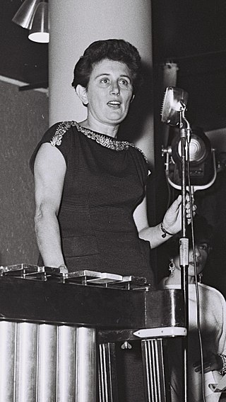
Ruth Dayan was an Israeli social activist who was the founder of the Maskit fashion house. She was also the first wife of Israeli Foreign Minister and General, Moshe Dayan (1915–1981). Active in many social causes, Dayan was a recipient of the Israeli President's Medal of Distinction, the Solomon Bublick Award, and the Yigal Allon Prize, in recognition of her social empowerment efforts.

<span class="mw-page-title-main">Zvi Yehuda</span> Israeli politician (1887–1965)

Zvi Yehuda was a Zionist activist and later an Israeli politician.

<span class="mw-page-title-main">1921 in Mandatory Palestine</span>

Events in the year 1921 in the British Mandate of Palestine.

<span class="mw-page-title-main">Richard Kauffmann</span> German-born architect and town planner, active mainly in British Palestine

Richard Kauffmann (1887–1958) was a German-Jewish architect who migrated to Palestine in 1920. His architecture was influenced by Ludwig Mies van der Rohe, a proponent of the International Style, and was applied to the local landscape, laying the architectural groundwork for the nascent State of Israel and the White City, as Tel Aviv's International Style architecture became known.

<span class="mw-page-title-main">Kinneret Farm</span> Place in Northern, Israel

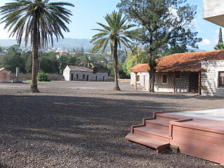
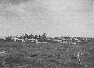
Kinneret Farm or Kinneret Courtyard was an experimental training farm established in 1908 in Ottoman Palestine by the Palestine Bureau of the Zionist Organization (ZO) led by Arthur Ruppin, at the same time as, and next to Moshavat Kinneret, a moshava-type village. The farm stood in close proximity to the shore of the Sea of Galilee. Until the early 1920s the farm was a hothouse and catalyst for social and economical innovation, which helped mold and create several essential institutions and infrastructure elements of the Yishuv, perpetuated in the State of Israel after 1948: communal settlement forms, women's rights movement, cooperative enterprises, a workers' savings and support bank, public health care system, a national paramilitary organisation. From 1949 on, after the establishment of the State of Israel, the courtyard served different lesser military and civilian purposes, was abandoned, then restored as a heritage site, and it 2007 it was opened as a museum and educational centre.

<span class="mw-page-title-main">Sursock Purchases</span> Largest Jewish land purchase in Palestine during the period of early Jewish immigration

The Sursock Purchases were land purchases made by Jewish organizations from the absentee landowning Lebanese Greek Orthodox Christian Sursock family, mainly from 1901 to 1925. These included the Jezreel Valley and Haifa Bay, as well as other lands in what became the Mandate for Palestine. These collectively formed the largest Jewish land purchase in Palestine during the period of early Jewish immigration.

<span class="mw-page-title-main">Moshava remnants in Kfar Malal</span> Zionist colony Ein Hay, established in 1912

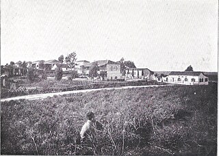
The remnants of the historic Moshava in Kfar Malal are buildings and items that were preserved from the Zionist Moshava established there in 1912, originally called Ein Hay. Between 1918 and 1921, the settlement's buildings were destroyed twice by the Ottomans and Arab rioters respectively. However, despite the difficulties, the settlement was rebuilt three times in total, and eventually expanded and thrived.

References

  1. 1 2 "Regional Statistics". Israel Central Bureau of Statistics. Retrieved 21 March 2024.
  2. 1 2 Richard Kauffmann, Die Bebauungsplaene der Kleinsiedlungen Kfar-Nahalal und Kfar-Jecheskiel ('The construction plans for the agricultural small housing estates Kfar Nahalal and Kfar Jecheskiel'), published by the Department for Agricultural Colonization of the Zionist Executive, Jerusalem (1923), in German.
  3. Mordechai Aviam (2011). "The Sabbath Boundary at Timrat Archived 2014-09-07 at the Wayback Machine ". In Eretz Magazine. A Hebrew version of the article is also available.
  4. a total of 16,000 dunams, with 90 families, according to List of villages sold by Sursocks and their partners to the Zionists since British occupation of Palestine, evidence to the Shaw Commission, 1930
  5. Bernard Reich and David H. Goldberg (2008). Historical Dictionary of Israel (2 ed.). Scarecrow Press. p.  329.
  6. "Moshav Nahalal Is Founded - Central for Israel Education". 11 September 2022.
  7. "Degania & Nahalal". UNESCO World Heritage Centre. 30 June 2000. Retrieved 16 April 2020.
  8. "Palestine Census ( 1922)" via Internet Archive.
  9. Sanagan, Mark (2013). "Teacher, Preacher, soldier, Martyr: Rethinking 'Izz al-Din al-Qassam". Die Welt des Islams . 53 (3–4): 315–352. doi:10.1163/15685152-5334p0002.[ permanent dead link ] p.342
  10. Hillel Cohen, Year Zero of the Arab-Israeli Conflict: 1929 Brandeis University Press 2015 ISBN   978-1-611-68811-5 p.30.

Commons-logo.svg Media related to Nahalal at Wikimedia Commons