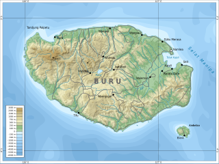
Buru is the third largest island within the Maluku Islands of Indonesia. It lies between the Banda Sea to the south and Seram Sea to the north, west of Ambon and Seram islands. The island belongs to Maluku province and includes the Buru and South Buru regencies. Their administrative centers, Namlea and Namrole, respectively, have ports and are the largest towns of the island, served by Namlea Airport and Namrole Airport.

Pramoedya Ananta Toer was an Indonesian author of novels, short stories, essays, polemics and histories of his homeland and its people. His works span the colonial period under Dutch rule, Indonesia's struggle for independence, its occupation by Japan during the Second World War, as well as the post-colonial authoritarian regimes of Sukarno and Suharto, and are infused with personal and national history.

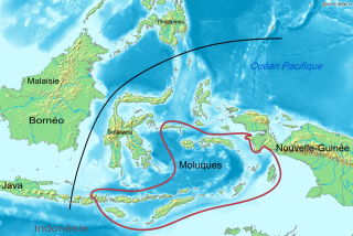
Maluku is a province of Indonesia. It comprises the central and southern regions of the Maluku Islands. The main city and capital of Maluku province is Ambon on the small Ambon Island. The land area is 46,150.92 km2, and the total population of this province at the 2010 census was 1,533,506 people, rising to 1,848,923 at the 2020 census. The official estimate as at mid 2022 was 1,881,727. Maluku is located in Eastern Indonesia. It is directly adjacent to North Maluku, Southwest Papua, and West Papua in the north, Central Sulawesi, and Southeast Sulawesi in the west, Banda Sea, East Timor and East Nusa Tenggara in the south and Arafura Sea, Central Papua and South Papua in the east.

The Obi Islands are a group of 42 islands in the Indonesian province of North Maluku, north of Buru and Ceram, and south of Halmahera. With a total area of 3,048.08 km2, they had a population of 41,455 at the 2010 Census and 50,760 at the 2020 Census. The official estimate as at mid 2021 was 51,510.

The Seram Sea or Ceram Sea is one of several small seas between the scattered islands of Indonesia. It is a section of the Pacific Ocean with an area of approximately one hundred twenty thousand square kilometres (46,000 sq mi) located between Buru and Seram, which are two of the islands once called the South Moluccas. These islands are the native habitat of plants long coveted for their use as spices, such as nutmeg, cloves, and black peppercorns, and the seas surrounding them were busy shipping routes. The Seram Sea is also the habitat of several species of tropical goby and many other fish. Like many other small Indonesian seas, the Seram Sea is rocky and very tectonically active.
The Central Malayo-Polynesian languages (CMP) are a proposed branch in the Malayo-Polynesian subgroup of the Austronesian language family. The languages are spoken in the Lesser Sunda and Maluku Islands of the Banda Sea, in an area corresponding closely to the Indonesian provinces of East Nusa Tenggara and Maluku and the nation of East Timor, but with the Bima language extending to the eastern half of Sumbawa Island in the province of West Nusa Tenggara and the Sula languages of the Sula archipelago in the southwest corner of the province of North Maluku. The principal islands in this region are Sumbawa, Sumba, Flores, Timor, Buru, and Seram. The numerically most important languages are Bima, Manggarai of western Flores, Uab Meto of West Timor, and Tetum, the national language of East Timor.
The blue-fronted lorikeet also known as the Buru lorikeet, is a parrot endemic to the Indonesian island of Buru.
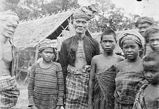
Buru people is an ethnic group mostly living on Indonesian island Buru, as well as on some other Maluku Islands. They also call themselves Gebfuka or Gebemliar, which literally means "people of the world" or "people of the land". Buru people are related to the eastern Indonesian anthropological group and from an ethnographic point of view are similar to other indigenous peoples of the island Buru. They speak the Buru language.

Lisela or Rana people is an ethnic group mostly living on Indonesian island Buru, as well as on some other Maluku Islands. They belong to the eastern Indonesian anthropological group and are sometimes referred to as northern Buru people. From an ethnographic point of view, Lisela are similar to other indigenous peoples of Buru island. They speak the Lisela language.
Kayeli people is an ethnic group mainly living on the southern coast of the Kayeli Gulf of Indonesian island Buru, mainly from the Kaiely Gulf. From an ethnographic point of view, Kayeli are close to other indigenous people of Buru, such as Lisela and Buru.
Kayeli is an extinct Austronesian language once used by the Kayeli people of the Indonesian island Buru. Two dialects were recognized, namely Leliali (Liliali) and Lumaete.
Lisela, also called Li Enyorot, is an Austronesian language; in 1989 it was spoken by about 11,900 Lisela people mostly living in the northern part of Indonesian island Buru. It is also preserved among the small Lisela community on the Ambon Island.

Ambelau or Ambalau is a volcanic island in the Banda Sea within Maluku Islands of Indonesia. The island forms an administrative district which is part of the South Buru Regency of Maluku province, Indonesia. It has a land area of 201.7 km2, and had a population of 6,846 at the 2010 Census. The administrative center is Wailua, a settlement located at the south of the island. About half of the island's population is composed of indigenous Ambelau people who speak the Ambelau language; the other half are mostly immigrants from the nearby Maluku Islands and Java.

Buru Regency is a regency of Maluku province, Indonesia. When it was first created on 4 October 1999, the regency encompassed the entire island ; but on 24 June 2008 the southern 40% of the island was split off to form a separate Buru Selatan Regency. The residual Buru Regency comprises the northern 60% of the island of Buru and covers an area of 7,595.58 km2. The population at the 2010 census was 108,445 and at the 2020 census this had increased to 135,238. The principal town lies at Namlea.

South Buru Regency is a regency of Maluku, Indonesia. It was created on 24 June 2008 by being split off from the existing Buru Regency. It is located on the island of Buru, of which it comprises the southern 40%. The Regency covers an area of 5,060 km2, and it had a population of 53,671 at the 2010 Census, rising to 75,410 at the 2020 Census. The principal town lies at Elfule in Namrole District.
Namrole Airport is an airport on Buru island, which is one of the Maluku Islands in Indonesia.

Manipa Island is an island in West Seram Regency, Maluku Province, Indonesia. It is located 8 km off the western coast of Kelang at the western end of Seram Island and 25 km off the western coast of Buru. Including adjacent small islands, it covers an area of 159.71 km2. The inhabitants speak the Manipa language, as well as Indonesian and Ambonese Malay.

Major TNI Johannes Abraham Dimara was an Indonesian National Hero from Papua.
Namlea is a town and kecamatan on the northeastern coast of the Indonesian island of Buru. It is the capital of the Buru Regency.
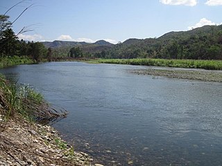
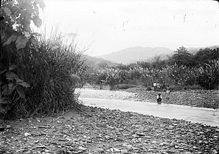
The Waeapo River is a river which flows on the island of Buru, Maluku, Indonesia. It is one of the main rivers of the island, draining towards the Banda Sea in the northeast of the island.
